The Fog of War
The fog of war is a common gaming term describing the rules
which define when enemy units are visible on a map. Most games
have simple parameters that define when an enemy is visible,
usually based solely on the distance to a friendly unit.
Although the PBeM-Engine tries to keep most rules simple and
straight-forward, the "Fog of War" is a bit more
complex in order to make the game less predictable and to better
simulate a number of unit types which define their usefulness
not by the weapon strength but by their stealth capabilities.
Sight Range Values
Three values define when enemy units are visible on the map:
- Sight Range
- Sight Deterioration
- Camouflage
Sight Range is a value between 1 and X defining how
far a unit can see on the map.
Sight Deterioration is a percentage value defining how
the quality of the information within the sight range of a unit
deteriorates with every square.
Camouflage is a percentage value defining how visible
a unit is on the map (100% = visible, 0%=invisible)
Note 1: Terrain elevation has a direct relation to
sight range. Elevation is added to sight range assisting units
in viewing more of the terrain if located on a hill or mountain.
Terrain though has not yet been incorporated into sight
range blocking calculations. Therefore, hills, mountains or any
other terrain elevation values do not block sight (for now).
Note 2: Also note that some units might not profit
from this added range. After reading thru the example on the
right, you will notice that the sight of Unit A deteriorates at
a rate of 20% so giving this unit an added range of 4 or 5
squares does not help much at all.
|
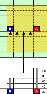
Example:
Unit A has a sight
range of 4 and a sight deterioration of 20%. If unit A looks
west, it will see 100% of the square to its immediate left, 80%
of the square to the left of the first, and so on. By the time
this reaches the square where unit B is deployed the sight will
have deteriorated to 40%. If
unit B is visible to unit A will now depend on the camouflage
value of unit B. If unit B now has a camouflage value of 65%,
then it will not be visible to A since its visibility is 35%,
compared to the 40% sight of unit A.
Comment:
Although this might seem overly complicated at first glance, it
allows the design of much more challenging units. In the
"Panama" scenario for example, guerilla units are not particularly
powerful, with only light weapons and little
armor, but given
their "stealthiness" they do represent a challenge
since they are easily able to infiltrate areas where other unit
types would be spotted quickly. The same scenario also
contains a soviet submarine unit type with similar settings.
Although the sub is no challenge to a surface ship in either
weapon strength, weapon range or armor, its capability to roam
undetected gives these unit types very interesting options. |