|
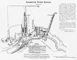
MAP AND AERIAL PHOTOGRAPHS Our first map is of the FALMOUTH DOCKS ESTATE, taken from a booklet published in 1897. There are many interesting. features to be seen on it including the foundry and shipbuilding yard managed by Cox and Co who were eventually to become the major engineers in the docks. Cox Brothers was founded in 1878 but had another partner at that time and were known as Cox, Farley and Company. As with all the images, click on them for larger versions.
The next two scans come from a small card that was distributed to ship-owners as a promotional document showing the layout of the yard and the details of work that could be carried out. Probably printed after 1935 but before 1938.
Below is the first aerial shot of the docks. It was taken to commemorate the completion of No 4 dry-dock in 1928.
A modern viewer who is familiar with the layout of the docks will notice the lack of wharves on the western side of the Western Wharf. The first one would only come into use in 1933. One important feature that can just be seen in the harbour (bottom right) is the shape of the floating crane, Titania (click here for large scale photo), visible to all and sundry in Falmouth up until the 1950's/60's.
The map shows Falmouth Docks as it was in 1933. This was produced by Ordinance Survey Cartographers and it is possible to see all of the Railway system in the dock-yard. A very important acquisition to the Docks was the newly constructed Empire Wharf. The wood used for the main piles was from Queensland, Australia. This was the forerunner for construction of all future wharves.
The next photo was taken in 1933/34. It is a good view of the Docks. The dredger can be seen working in the inner basin developing deeper water. By now the first of the extra wharves has been completed and a ship berthed alongside. This wharf was named the 'Empire' in traditional fashion. It may have got its name because the timber used to make it came from the British Empire.
The photo above shows Falmouth's inner harbour and docks, circa 1934. Many tugs can be seen. These were run by the Falmouth Towage Company and Falmouth Docks and Engineering Company. The Dock Company tugs were built by Cox and Company who later amalgamated with Mr John Silley to become Silley, Cox and Co Ltd. This soon became a name that was synonymous with the ship repair industry and known throughout the world of shipping. Mr Silley originally came from the London firm of Green and Silley Weir.
Next is a photo taken in the late 1950's showing two new wharves (named County and Duchy) that were built in this decade. Falmouth had by now become a major oil tanker port since, after the 2nd World War, oil was required everywhere. These tankers needed repairing and Falmouth, being the first and last port in Britain, strategically, became the premier port. This entailed the foresight on the part of the Dock's owners to build extensive wharves to accommodate tanker fleets that were becoming both larger in numbers and physically bigger. However, they were nothing compared to the "Super Tanker" we see today. Another point of interest in this photograph is that a floating dock can be seen alongside the Empire Wharf (centre left). It was towed to Falmouth in 1951 from the Royal Navy Dockyard in Bermuda. Previously, she had been based in Alexandria and many naval battleships and cruisers were docked in her. It arrived from Bermuda after a tow of 31 days with the aid of the Admiralty tugs 'Reward', 'Warden' and 'Prosperous'. The Falmouth tugs then took charge: the 'Lynch', 'Fairnilee', 'Northgate Scott' and finally, the 'Codicote Scott'. Called the AFD5 (Admiralty Floating Dock 5), she had a complete overhaul, but was never used commercially as she still belonged to the Admiralty. Eventually she was sold in 1966. It was towed away but unfortunately hit bad weather in the Atlantic, broke up and sank. What a tragic ending!
Now we move to1997/98 and more up-to-date photos. Notice the new bit of land inside the Northern Arm in the lower photo. This was originally planned as an area to take a RO RO (Roll on- Roll off) ferry terminal with services to run from Falmouth to (probably) Spain or Portugal. Unfortunately, competition was and still is very fierce in this area of shipping and so, up to the present, that side of the business is on hold. However, the photos do show one of Falmouth Dock's specialities - P&O Ferries and Irish Ferries ships in for repair.
|
| Home | Time | Energy | Workforce | Movement | Further Work | Industrial Relations | Dry-docks | Alterations | Buildings and Workshops | Personalities | Flow of the Job | Engine Room | War Work | Re-cycling | Sports | Docks Tours | Thoughts on the Docks | The Future | Credits and Bibliography | Links | |