gis 520 portfolio
advanced geospatial analysis - spring 2014

Editorial Staff:
Steven Mohr - [email protected]
RALEIGH, THURSDAY, APRIL 24, 2014
"All the News
That's Fit to Print"
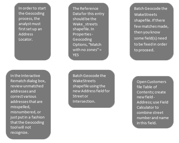
Geocoding Tabular Data
Problem
In this assignment, a company was contracting me to use GIS technology to analyze where there customers currently are and how to use this data to increase their customer base. I was given various data from the Wake County website, which I Geocoded in order to find the correct addresses this data corresponded with. In addition, through various lapses in data, I was able to locate certain addresses that were not part of the current customer base but came from the same area and most likely a close demographic (and therefore a possible future costumer to add to the advertisement campaign).
Analysis Procedures
Strategies: In order to solve a problem such as this, the contracted analyst must have an ArcGIS license and software package (preferably ArcGIS 10.1 or newer), this analyst must have a working knowledge of the Geocoding functions within this system, and he or she must have the data to work with (e.g. ZIP Code data, Street data, Boundary data, and Customer data). This data does not have to be complete, but there needs to be enough of it for ArcGIS functions to effectively generalize and surmise. This allows the analyst to fill the holes and accurately analyze the data.
Methods: To build the right information that could be used in the analysis, I had to Geocode to the Wake County street data I downloaded. To do this, there were several steps that needed to be taken.
Application & Reflection
Problem description: A similar situation could be if I worked in Public Utilities and I needed to get an updated list of all the addresses that use city garbage pickup as opposed to one of several independent contractor pickups. I would need to provide an updated map of the addresses’ location per block for my truck drivers.
Data needed: In order to do this, I would need a current list of the current patrons; shapefiles that show the streets, city boundaries, and all the addresses of citizens in the city; and ArcGIS 10.1 or newer software and the Geocoding tool within.
Analysis procedures: I would use the new list of patrons and use the Geocoding tool to match the addresses of the patrons to addresses of all local citizenry. This would allow me to build a map of the addresses that could be broken down by street and given to the garbage truck drivers.
Additional Assignment Reflection
When I think of the standard uses of GIS tools, I think of governments using GIS for zoning maps and buffers that can calculate exact distances. Right away, I never picture private companies using these tools in order to verify and increase their customer base. However, this project shows that this very application is not only a reality but a particularly useful reality that should be used as much as possible. This assignment showed that in fairly quick time a company can verify the addresses of its past customers (and therefore save lots of money by not sending out superfluous mail), better protect the identity of its customers (by not sending mail to the wrong addresses), and can increase its customer base through logical suppositions regarding local demographics.
Results


This screen shot shows Geocoding tool's Interactive Rematch dialog box.
This screen shot shows a results of the Geocoding by streets process.
World News

Local Traffic

Environmental News

Regional Weather
