Geography
 Push mousebutton on the map to reveal more detailed map
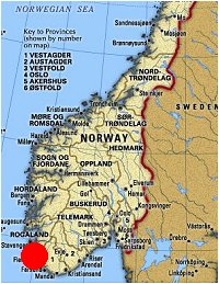
The farming hamlet of Åvendal is situated in Norway's south eastern part, in the county of Rogaland, just south of the District border between Sokndal and Eigersund Districts.
It lies in a narrow valley with Norway's Highway 44 running through it straight besides the 3 farms.
The area is sparsely populated with the nearest town being Egersund 10 miles to the north. Egersund has about 13.000 inhabitants while the Sokndal district center
Hauge is much smaller. A popular place and touristattraction is the old port Sokndalsstrand which has been much renovated during the last decade.
The name Åvendal means a small valley divided by a brook.
The way it has been spelt has varied through different periods.
Norway was under Danish rule for over 350 years up to 1814, and the official written
language was Danish. Because of that you will find the name spelt as different as Aundall(1606),
Ougendahl(1641), Iugendahl(1665) and Ougendahl(1701).
Even in more modern times the name has been spelt in different ways with brothers Georg Ougendal,
who ran the farm between 1919-61 and
Hans Kristian Åvendal using different spellings.
( Just to put it straight, the letter Å , which is not found in the English language, is pronounced similar to an O )
| 