 |
 |
 |
 |
 |
 |
 |
 |
 |
 |
|
 |
 |
 |
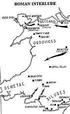
| Early Roman Wales In the years following 70AD fresh forts were built by the Romans at strategic locations along the Welsh borders, where the tribes resisted, using guerrilla tactics unfamiliar (and thoroughly exasperating) to the Roman troops. At least 35 smaller fortified camps were built to support these troops, and linked with a network of roads. The Deceangli of the north and the Demetae of southwest Wales offered little opposition to the Romans. Such is not the case with the Silures in the south-east and the Ordovices in the north-west, whose territories are dotted with Roman strongholds. The Silures gradually adapted to the presence of the Romans among them and gave little trouble after the mid 2nd century. Such could not be said for the Ordovices. The north-west of Wales remained a source of irritation to the Romans for generations |
| A falcon's eye view of Segontium from the east in a superb reconstruction by John Banbury in 1996. Showing the fort, as it would have looked in c.A.D.250, the drawing is based on excavations made at the site in 1921-23 and 1975-79 The Roman name for Caernarfon is recorded in the Antonine Itinerary of the second-century AD as Segontio, and is placed 24 Roman miles from Canovium at the starting-point of the route from Caernarfon to Deva (Chester, Cheshire). The accepted Roman name for Caernarfon is Segontium, which very likely means 'the place or home of the Segontii'; implying that there was a tribe of that name in the area. The modern Welsh place-name Caernarfon is readily translated as 'the fort at the river mouth' The dynamic Roman governor of Britain, Gnaeus Julius Agricola, established the first fort here in the autumn of AD77. It was originally built to command the Menai Straits and thus to enable the capture of the island of Mona (Anglesey) which it overlooked to the northwest. The site underwent a number of reconstruct ional phases during its lifetime and was occupied until c. AD383. The original Flavian timber-built fort was apparently burned and was either abandoned or destroyed, to be replaced by a stone fort during the reign of Hadrian. The fort remained of key importance until at least the late-fourth century. The latest coin from the site is that of Gratian (367-383). |
 |
 |
| Settlements (vici) grew up around the major Roman forts of Caerleon, Caernarfon, and Casws. The Romans granted the right to build a "civitas", or self-governing city, to tribes whose allegiance was secure. The Romans attempted to subvert allegiance to the old Celtic gods by linking them with Roman gods. Thus, for example, the Roman god Mars was linked with the Celtic Oculus. Although the language of the Romanised cities, was Latin, the vast majority of the population still spoke a version of Brittonic. Throughout the second half of the 4th century the Empire became increasingly unstable; barbarian attacks on the borders increased, and it seems that the legions were gradually withdrawn from Wales to counter threats on the continent. By 390AD there were probably no Roman troops remaining within the borders of Wales. In the next few decades most of the legionaries in England followed and Britannia was essentially undefended. |
| Caer Gai, Gwynedd Located on a spur in a valley the fort covers an area of 4� acres (1.7 ha) and was furnished with timber buildings never rebuilt in stone. The fort was occupied from c. AD75 until c.130. There are two Roman practice works nearby at Rhyd Sarn NGRef: SH877314 OSMap: LR124/125 Type: Minor Settlement, Fort. |
| Tomen y Mur, Gwynedd Agricola, slightly reduced in size in c. 110, when the walls were rebuilt in stone, and finally abandoned in c. AD 140, built this auxiliary fort in AD 78. A small amphitheatre to NE was built perhaps to compensate the troops for being posted to such a remote location. NGRef: SH7038 OSMap: LR124 Type: Fort |
| Bryn y Gefeiliau, Gwynedd Bryn-y-Gefeiliau - The Hill of the Metalsmiths This fort was built c. AD90, and Trajanic pottery and "a little Samian ware" of the Antonine period probably point to the fort becoming disused before the third century. This fort is also known by the alternate name Caer Llugwy (possibly "the Camp of Lugh's Egg"). NGRef: SH7457 OSMap: LR115 Type: Fort |
| Caerhun, Gwynedd Plan of the fort at Canovium The first fort was built of timber in the late first century and some interior buildings were replaced in stone in the early second century. The Antonine Itinerary was a list of routes and posting-stations used by the Roman army of the late-second century, the British section of this document has fifteen such itineraries, and the Caerhun fort is included in 'Itinerary Eleven - The route from Segontium to Deva'. The route is listed as 74 (Roman) miles long; starting from SEGONTIVM (Caernarfon, Gwynedd) the next station Conovio is 24 miles away, which can only be Caerhun.proceeds another 18 miles to VARIS (St. Asaph, Clwyd?) then on to its eastern terminus at DEVA (Chester, Cheshire), a further 32 miles |
 |
| After the fort was destroyed in c. AD200, the civilian settlement or vicus outside the defences was only sporadically occupied until the 4th century when it was finally abandoned NGRef: SH776704 OSMap: LR115 Type: Minor Settlement, Fort. |
 |
| Pen Llystyn, Gwynedd Plan of Pen Llystyn Fort, oriented with north at the top. Judging from the number of barrack blocks which are seen clearly on the plan, each with ten double-rooms and a centurial block at the end nearest the defences, the fort housed a miliary infantry cohort with a nominal 960 foot-soldiers.The fort stands on a west facing slope on the east bank of the Afon Dwyfach, near Bryncir on the A487 trunk road from Porthmadog to Caernarfon.It lies within the angle formed where the postulated Roman military road between the forts at Segontium (Caernarfon) and Tomen-y-Mur makes a marked change of alignment. |
| The road alters heading from south-south-east to east-south-east, about a kilometer to the south of the site. The fort faces south-west across the river valley and was obviously sited to police the Ganganorum Promontorium (LLeyn Penninsula), the home of the Gangani tribe. There is a temporary camp nearby at Derwydd-bach Farm (SH4745), and a substantial Roman building at Tremadog (SH5540), along the line of the postulated road east to Tomen-y-Mur NGRef: SH4844 OSMap: LR123 Type: Fort |
| Although there are of course many other forts from the Roman era, I have concentrated on the sites local to my home. For a more detailed listing of Roman Britain an excellent site can be found as http://www.roman-britain.org/main.htm |
 |