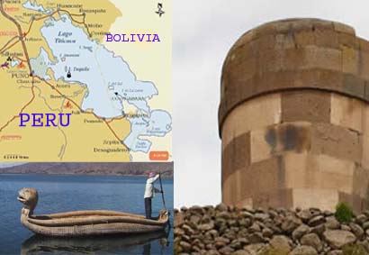
Puno is a region in southeastern Peru. It is bordered by Bolivia on
the east, the Madre de Dios Region on the north, the Cusco and Arequipa
regions on the west, the Moquegua Region on the southwest, and the
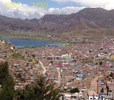
Tacna Region on the south. Its capital is the city of Puno, which
is located on Lake Titicaca in the geographical region known as the
Altiplano or high sierra.
The Puno region is located in the
Collao Plateau. The western part of Lake Titicaca, which is the world's
highest navigable lake, is located in the region. The Andean mountains
make up 70% of the region's territory, and the rest is covered by
the Amazon rainforest.
The climate is cold and dry, with
a four-month rain season. On the other hand, the climate of the rainforest
is warm. The water resources are taken from the Lake Titicaca, 50
lagoons and more than 300 rivers. There is also an important potential
in underground waters.
HISTORY
In ancient times, the Collao plateau
was inhabited by Aymara groups (Collas, Zapanas, Kallahuayos and Lupacas).
The Quechuas came later.According to chronicler Inca Garcilaso de
la Vega, these ancient times coincide with the legend of Manco Capac
and Mama Ocllo, who emerged from the waters of Lake Titicaca to found
the Inca Empire.The Aymara culture, also known as Putina, was the
most important and influential pre-Hispanic culture in the region.
During the Viceroyship, Puno was
the obliged route for travelers going to Potosí, Bolivia. In
1668, viceroy Conde de Lemos established San Juan Bautista de Puno
as the capital of the province of Paucarcolla. Later, it was called
San Carlos de Puno, in honor of the ruling king, Charles II of Spain.
In 1870, the railway route Arequipa-Puno was installed and navigation
in Lake Titicaca started.
LAKE TITICACA
Lake Titicaca is the highest commercially
navigable lake in the world[1], at 3,812 m (12,507 feet) above sea
level. Located in the Altiplano high in the Andes on the border of
Peru and Bolivia, at 16°S 69°W, Titicaca has an average depth
of 107 m,[2] and a maximum depth of 281 m. The western part of the
lake belongs to the Puno Region of Peru, and the eastern side is located
in the Bolivian La Paz Department. More than 25 rivers empty into
Titicaca, and the lake has 41 islands, some of which are densely populated.
Titicaca is fed by rainfall and
meltwater from glaciers on the sierras that abut the Altiplano. It
is drained by the Desaguadero River, which flows south through Bolivia
to Lake Poopó. This accounts for less than five percent of
the lake's water loss, however, the rest is caused by evaporation
as a result of the strong winds and sunlight at this altitude.
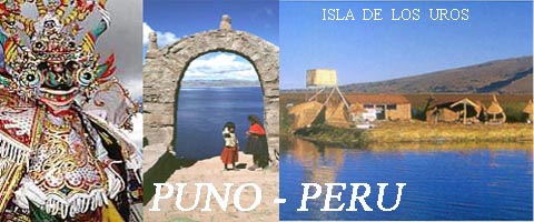
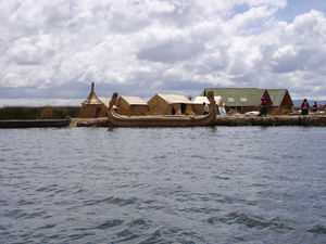
ISLAND OF THE UROS
Titicaca is notable for a population of people who live on the Uros,
a group of about 43 artificial islands made of floating reeds. These
islands have become a major tourist attraction for Peru, drawing excursions
from the lakeside city of Puno. Their original purpose was defensive,
and they could be moved if a threatarose. One of the islands retains
a watchtower largely constructed of reeds.
ISLAND OF THE AMANTI
Amantaní is another small
island in Lake Titicaca populated by Quechua speakers. About 800 families
live in six villages on the basically circular 15-square kilometer
island. There are two mountain peaks, called Pachatata (Father Earth)
and Pachamama (Mother Earth), and ancient ruins on the top of both
peaks. The hillsides that rise up from the lake are terraced and planted
with wheat, potatoes, and vegetables. Most of the small fields are
worked by hand. Long stone fences divide the fields, and cattle, sheep,
and alpacas graze on the hillsides.
There are no cars on the island,
and no hotels. A few small stores sell basic goods, and there is a
health clinic and school. Electricity is produced by a generator and
limited to a couple of hours each day.Some of the families on Amantaní
offer a meal or overnight stay to tourists, arranged through tour
guides. Guests typically take food staples (cooking oil, rice, sugar)
as a gift.
Isla Del Sol
Situated on the Bolivian side of the lake with regular boat links
to the Bolivian town of Copacabana, Isla del Sol ("Island of
the Sun") is one of the lake's largest islands. In Inca mythology
it figured as the place of their origin, and several important Inca
ruins exist on the island. Its economy is mainly driven by tourism
revenues, but subsistence agriculture and fishing are widely practised.
An underwater archaeological research project was undertaken off the
Island of the Sun during 1989-92. Rare Inca and Tiahuanaco artifacts
were recovered, which are currently on display in a site museum in
Challapampa.[