

| HOME |
| Little Red River |
| Norfork River |
| White River |
| River Reports |
| Fly Patterns |
| Seasonal Fly Choices |
| Local Entomology |
| About Generation |
| How-to Information |
| Fishing License |
| Local Forecast |
| About Me |

Your Virtual Guide For Flyfishing Arkansas' Blue-ribbon Trout Waters
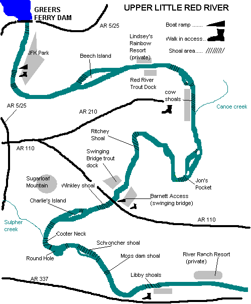
Little Red RiverUpper Little Red RiverJFK Park to Cow Shoals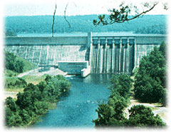 The Little Red River's trout waters flow from the base of Greer's Ferry Dam, completed in 1963 (President
John F. Kennedy dedicated the structure as his last public act before being assassinated in Dallas). JFK park
lies on river left at the base of the dam and provides great camping and river access with sometimes "crowded" but
usually productive fly-rodding action. Waters from the Greers Ferry Hatchery flow into the river through three
large-capacity pipes spaced out a few hundred yards apart, providing highly oxygenate water which contains
some loose hatchery feed. Trout gather around these out-flows in large numbers to take advantage of the
easy living. Tiny sowbugs, midges (pupas and dries), and soft hackles fished on six or seven "X" tippet
will sometimes take good numbers of small fish. Larger trout will feed in these areas as well, but they
tend to be quite wary. These fish see lots of anglers and tackle thrashing about and are "well-educated".
From the dam to the third pipe is a "catch and release" zone, dictating the use of single-barbless hooks only. Just
past the third pipe lies the boat ramp, below which the river narrows into a nice fast chute. This is a good
spot to "swing" woolly buggers and tiny soft-hackles. Sometimes you'll spot some rather hefty rainbows making their way upstream through this shallow section to feed in the deep pools above. Using down-and-across casts from river-left you can work the entire chute with a woolly bugger or soft-hackle, then switch to a small sowbug or midge pupa and work your way back up towards the ramp. Below the chute the river slows and deepens into a long, calm pool
with frequent insect hatches and consistent nymphing action. Best choices are size 20-24 midges and size 18 pheasant-tail nymphs. Size 16-18 sowbugs in dark gray or tan also produce good numbers of average to small rainbows with the occasional brookie. Be especially cautious however when fishing this area. When the "horn" from the dam sounds off signalling water-release, it's time to get out. This gentle meandering creek will quickly become a raging river.
The Little Red River's trout waters flow from the base of Greer's Ferry Dam, completed in 1963 (President
John F. Kennedy dedicated the structure as his last public act before being assassinated in Dallas). JFK park
lies on river left at the base of the dam and provides great camping and river access with sometimes "crowded" but
usually productive fly-rodding action. Waters from the Greers Ferry Hatchery flow into the river through three
large-capacity pipes spaced out a few hundred yards apart, providing highly oxygenate water which contains
some loose hatchery feed. Trout gather around these out-flows in large numbers to take advantage of the
easy living. Tiny sowbugs, midges (pupas and dries), and soft hackles fished on six or seven "X" tippet
will sometimes take good numbers of small fish. Larger trout will feed in these areas as well, but they
tend to be quite wary. These fish see lots of anglers and tackle thrashing about and are "well-educated".
From the dam to the third pipe is a "catch and release" zone, dictating the use of single-barbless hooks only. Just
past the third pipe lies the boat ramp, below which the river narrows into a nice fast chute. This is a good
spot to "swing" woolly buggers and tiny soft-hackles. Sometimes you'll spot some rather hefty rainbows making their way upstream through this shallow section to feed in the deep pools above. Using down-and-across casts from river-left you can work the entire chute with a woolly bugger or soft-hackle, then switch to a small sowbug or midge pupa and work your way back up towards the ramp. Below the chute the river slows and deepens into a long, calm pool
with frequent insect hatches and consistent nymphing action. Best choices are size 20-24 midges and size 18 pheasant-tail nymphs. Size 16-18 sowbugs in dark gray or tan also produce good numbers of average to small rainbows with the occasional brookie. Be especially cautious however when fishing this area. When the "horn" from the dam sounds off signalling water-release, it's time to get out. This gentle meandering creek will quickly become a raging river.The next pool is known as the "power line pool" because of the large power-transmission lines that span the river. This pool is long and sometimes quite deep with large beds of moss. Drift-fishing from a boat, an angler can slowly drift along with the current and fish along the sides of these moss beds with a sowbug or other weighted nymph about three feet below a strike indicator. Some good-size and very colorful rainbows can be taken fishing in this manner. Fallen trees and log-jams that dot the banks are good places to get a brown or two since they seem to like hanging out around "wood". At the end of the "power line pool", the river splits forming a long island known as "Beech Island". The main channel is river-left but shoals on both sides of the island will produce fish. Good numbers of browns and even some rainbows spawn here each fall so the angler should be cautious not to damage the reds while wading or navigating a boat through this area. This far from the dam, you will not be able to hear the horn if generation begins so be watchful of the river. If it appears to be getting a little swifter, get out immediately because it will soon be getting deeper! Below the island is another long deep pool with Red River Trout Dock and Lindsey's Rainbow Resort on opposite sides of the river. This area is very popular with bait-fisherman and doesn't offer much to the flyrodder who is looking for any sort of tranquility. Downstream the docks however, there are a couple of small wadable shoals that offer some good action to those willing to anchor the boat and get into the water. A little further down, the river bends sharply to the right marking the top of the Cow Shoals area. This is where the Arkansas Fly-fishers club planted eggs and fingerling browns giving rise to this awesome brown-trout fishery. The oldest and largest browns in the river return here each year to spawn. All of us who fish this river are forever indebted to those pioneering anglers. A small island on river right displays a sign signalling the beginning of the "catch and release" zone. Walk-in access is provided to this "classic" shoal by the Arkansas Game and Fish Commission and the water is easily waded and fished. During the spawning season, large numbers of browns gather here to take part in the annual ritual, giving anglers a real opportunity to catch the fish of a lifetime. The down-side is that it is "no secret" and fishing pressure here is extremely heavy from early October through late December. Good fly-fishing etiquette is a must, not only to keep temperamental anglers from getting into a tiff, but also to protect the resource. If you must fish for spawners, please use slightly heavier equipment so you can quickly land and release fish reducing the mortality rate. Learn to identify active reds and avoid wading through them to ensure survival of the fragile eggs incubating in the small gravel. The best approach is to leave the spawning fish alone and fish for the pre-spawn trout that hang out below the reds picking off loose roe that gets lost in the current. Size 14 to 18 egg patterns weighted with tiny split shot and fished two feet below a strike indicator can be "big-fun". During the rest of the year, decent numbers of juvenile brownies remain in the area and are usually quite willing to take midges and other small offerings for anglers who like to use ultra-light one to three-weight rods. The deeper water just above and below the shoals will sometimes surprise you with a big rainbow, and with the "fall" crowds thinned, it can be a rewarding experience. Canoe Creek to Barnett AccessAt the bottom of the Cow Shoals area, Canoe Creek enters from river-left. The river narrows and tumbles over a short series of riffles before widening into another long pool dotted with shallow humps and plenty of log piles and moss beds. Lots of big browns and fat rainbows inhabit these waters giving the drift-boat anglers some good action. At the bottom of this pool, the river makes an "S" bend and flows into an area known as Jon's Pocket. Although there is no public access here, a few local guides are able to use private boat ramps and provide clients with a fun-filled day of fly fishing in these usually uncrowded waters. Sowbugs, pheasant-tails, lightning bugs, and other weighted nymphs fished two to three feet below an indicator are generally productive. At the bottom of Jon's pocket is another great shoal that is being used more and more by spawning browns. This area can be accessed by boat from the Barnett area by those willing to motor several miles upstream and drag their boat over some shoals. A small island exists here with the main channel on river-left. The backside of the island is choked with moss and log-jams but if the flow is just high enough, a few fish can be caught in the pockets. River-left is lined with private docks providing some pleasant conversation with local home-owners as you fish through. At the end of the small island, the river again deepens and drift-fishing is the order. This is good nymphing water with good populations of both rainbows and browns. This area is also home to some record-class fish that can sometimes be spotted suspended in the deeper sections. Local guides know these fish almost by name and cordially give them the respect they are due.The next feature along the river is Ritchie Shoal. This is sort of a rough-and-tumble shoal with lots of small boulders dotting the gravel stream bed, making for lots of sheered pins and destroyed props for boaters who attempt to motor over. It is best to respect river and the wading anglers who live along this stretch to just get out and pull your boat through along the right bank. There is some great fly-fishing on this shoal with frequent insect hatches and consistent nymph and woolly-bugger action. This shoal however, does receive some pressure so if you want the water to yourself you'd better get here early.  Next is a long section lined on both sides with private residences and docks. It is mostly deeper water with some spotty moss beds and prop-eating shallows. It was in this stretch that Rip Collins put the river on the map with his World Record 40-lb,4-oz brown. Lots of bait-fisherman fish this area from Jon-boats and on a busy weekend the boat traffic can be quite distracting. Flyrodders however, can catch some nice fish by drifting downstream and fishing the drop-offs with heavily weighted sowbugs and nymphs below a strike indicator. As you move down the river, Sugarloaf mountain, one of the area's most prominent landmarks, looms in the southern sky making for some good photo opportunities. At the end of the pool lies Swinging Bridge trout dock on river-right, named after the old suspension-bridge that used to span the river before collapsing in a tragic accident that killed several church-group children some years ago. Barnett access is on river-left providing public boat launching and walk-in access to Winkley Shoals below. Arkansas highway 110 crosses the river between the ramp and the shoal and parking is available on both sides of the river.(An honor-system parking fee is asked for on the right side of the river since that side is actually private property) This area receives lots of stockers from the AGFC so action (as well as bait-fishing) is pretty consistent here. Next is a long section lined on both sides with private residences and docks. It is mostly deeper water with some spotty moss beds and prop-eating shallows. It was in this stretch that Rip Collins put the river on the map with his World Record 40-lb,4-oz brown. Lots of bait-fisherman fish this area from Jon-boats and on a busy weekend the boat traffic can be quite distracting. Flyrodders however, can catch some nice fish by drifting downstream and fishing the drop-offs with heavily weighted sowbugs and nymphs below a strike indicator. As you move down the river, Sugarloaf mountain, one of the area's most prominent landmarks, looms in the southern sky making for some good photo opportunities. At the end of the pool lies Swinging Bridge trout dock on river-right, named after the old suspension-bridge that used to span the river before collapsing in a tragic accident that killed several church-group children some years ago. Barnett access is on river-left providing public boat launching and walk-in access to Winkley Shoals below. Arkansas highway 110 crosses the river between the ramp and the shoal and parking is available on both sides of the river.(An honor-system parking fee is asked for on the right side of the river since that side is actually private property) This area receives lots of stockers from the AGFC so action (as well as bait-fishing) is pretty consistent here.
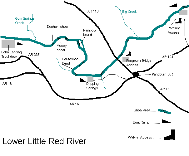
Winkley Shoals to Lobo Landing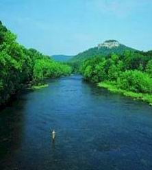 Winkley Shoals begins at the Highway 110 bridge and extends roughly 300 yards through some extremely shallow and rocky water providing some great pocket water for "high-sticking" nymphs and woolly buggers and making float-through very difficult for any type of craft except for canoes, kick-boats, or drift boats. Anyone who desires to cross this shoal in a boat should be prepared to get out and drag most of the way down and take out at some point downstream. The great part about this is that the next mile or so does not receive a great deal of fishing pressure (This is one of my favorite parts of the river for that reason). Below the third drop of Winkley Shoals there is a short section of flat water about two feet deep with a steady current flow that nearly always produces good numbers of small to average browns on nymphs and sowbugs. Occasional insect hatches bring these guys to the surface for some really great dry-fly action. If you see lots of fish rising, tie on a size 20 BWO (blue-winged olive) and cast it upstream of rising fish. If they don't take it try an Adams midge about size 20 or 22 and you should get some takes. If the fish still refuse your offering, try a gray or partridge-and-olive soft-hackle, size 16-20 fished on the "swing" and hold tight! I have caught as many as ten fish on consecutive casts here using this method. At the end of this pool there is a deep hole that generally holds some nice fish around the moss beds before the river splits again forming Charlie's Island. Both sides of the island fish well with the right side being a little more boat-friendly. Since the channels are so narrow, I typically drift through this area casting well out ahead of the boat in order to show the fish the fly before they see me coming. You can also beach the boat at the head of the island and wade down either channel swinging nymphs or soft-hackles down-and-across the current and usually take some nice fish. At the end of the island on river-right, there is a nice flat shoal that drops off suddenly into a deep hole with some log-piles in it. Fish this area with a heavily weighted sowbug suspended three to six feet below an indicator and you just might get your arm ripped off. The pool below, known as "Redbanks", is a fairly shallow pool that can be waded in low water making for some comfortable relief to the hot summer sun. Good numbers of fat rainbows can be taken on sowbugs or nymphs dead-drifted around the abundant moss beds. Below Redbanks there are several small islands with narrow chutes between them. This water holds some spawners in the fall and some good rainbows the rest of the year. Several locals have private access to this area and they tend to keep the trout well-schooled, but careful presentation and long leaders will get you some nice rewards. Below the islands, Sulfur Creek enters on river-right. This creek carries drainage from the Heber Springs area and can really muddy the water after heavy rains. Occasionally you may catch a small bass or bream near where the creek comes in. After another small shoal, the river widens and makes a left-turn into the "Round Hole". This is a deep hole with a nice current flowing through its center. Fish along the edge of the fast water with a sowbug and hold on, this is great brown-trout water. Afternoon hatches of BWO's tend to come off during the late summer and fall months and can provide some of the best dry-fly action on the river. Below Round Hole, the river again narrows and winds through what is known as Schroncher Shoals. This shoal is a long series of riffles and flats strewn with boulders and fast water. Wooly buggers and soft-hackles fished down and across will take lots of average fish and occasionally a big boy. This part of the river is inhabited by plenty of colorful young browns and a growing population of aggressive cut throats that can make for some tired arms at the end of a great day. Winkley Shoals begins at the Highway 110 bridge and extends roughly 300 yards through some extremely shallow and rocky water providing some great pocket water for "high-sticking" nymphs and woolly buggers and making float-through very difficult for any type of craft except for canoes, kick-boats, or drift boats. Anyone who desires to cross this shoal in a boat should be prepared to get out and drag most of the way down and take out at some point downstream. The great part about this is that the next mile or so does not receive a great deal of fishing pressure (This is one of my favorite parts of the river for that reason). Below the third drop of Winkley Shoals there is a short section of flat water about two feet deep with a steady current flow that nearly always produces good numbers of small to average browns on nymphs and sowbugs. Occasional insect hatches bring these guys to the surface for some really great dry-fly action. If you see lots of fish rising, tie on a size 20 BWO (blue-winged olive) and cast it upstream of rising fish. If they don't take it try an Adams midge about size 20 or 22 and you should get some takes. If the fish still refuse your offering, try a gray or partridge-and-olive soft-hackle, size 16-20 fished on the "swing" and hold tight! I have caught as many as ten fish on consecutive casts here using this method. At the end of this pool there is a deep hole that generally holds some nice fish around the moss beds before the river splits again forming Charlie's Island. Both sides of the island fish well with the right side being a little more boat-friendly. Since the channels are so narrow, I typically drift through this area casting well out ahead of the boat in order to show the fish the fly before they see me coming. You can also beach the boat at the head of the island and wade down either channel swinging nymphs or soft-hackles down-and-across the current and usually take some nice fish. At the end of the island on river-right, there is a nice flat shoal that drops off suddenly into a deep hole with some log-piles in it. Fish this area with a heavily weighted sowbug suspended three to six feet below an indicator and you just might get your arm ripped off. The pool below, known as "Redbanks", is a fairly shallow pool that can be waded in low water making for some comfortable relief to the hot summer sun. Good numbers of fat rainbows can be taken on sowbugs or nymphs dead-drifted around the abundant moss beds. Below Redbanks there are several small islands with narrow chutes between them. This water holds some spawners in the fall and some good rainbows the rest of the year. Several locals have private access to this area and they tend to keep the trout well-schooled, but careful presentation and long leaders will get you some nice rewards. Below the islands, Sulfur Creek enters on river-right. This creek carries drainage from the Heber Springs area and can really muddy the water after heavy rains. Occasionally you may catch a small bass or bream near where the creek comes in. After another small shoal, the river widens and makes a left-turn into the "Round Hole". This is a deep hole with a nice current flowing through its center. Fish along the edge of the fast water with a sowbug and hold on, this is great brown-trout water. Afternoon hatches of BWO's tend to come off during the late summer and fall months and can provide some of the best dry-fly action on the river. Below Round Hole, the river again narrows and winds through what is known as Schroncher Shoals. This shoal is a long series of riffles and flats strewn with boulders and fast water. Wooly buggers and soft-hackles fished down and across will take lots of average fish and occasionally a big boy. This part of the river is inhabited by plenty of colorful young browns and a growing population of aggressive cut throats that can make for some tired arms at the end of a great day. Once you get below Schroncher, you return to the more accessible part of the river. Many anglers will motor upstream from Lobo Landing to get to this point and weekend boat traffic can sometimes cut into your quiet time. The fish however, seem to get used to it, scattering when a boat comes through but regrouping soon after its gone. The next couple of miles are mostly flat water with a couple of small shoals scattered along the way. Drift-fishing from a boat is a good way to take fish while enjoying the scenery. The towering "Libby Bluff" makes a nice backdrop for some photos and abundant shade-trees along the banks provide a good place for lunch (or a nap). Drift sowbugs and nymphs below an indicator over the moss beds and shallow humps through this stretch and you'll catch a few nice rainbows and the occasional brown. Some of the browns in this part of the river reach "trophy" size so be ready for anything. 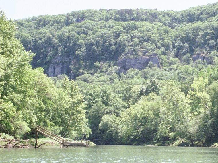 As you approach Libby Bluff, the river turns sharply to the left and narrows somewhat. The right bank is littered with "huge" boulders and a steep bank while the river-left is shallow. Fish nymphs out ahead of the boat for best results. Top-water action can also get cranked up pretty good in this stretch so don't be afraid to tie on a dry-fly. Moving downstream, the next feature is Libby Shoals. Public walk-in access is provided to this fairly short shoal by the AGFC and there are usually plenty of anglers. This shoal fishes good at times with nymphs or sowbugs suspended about two feet below an indicator. At the end of the shoal, the current spills into a deep hole that holds some nice rainbows for anglers willing to wade deep. After Libby shoals, there is a long, straight stretch of deep slow water with lots of moss and timber. River Ranch Resort occupies the left bank and is an extremely popular resort with rooms, a great restaurant, and boat rentals. This part of the river is mainly used by bait-fisherman and boat traffic can sometimes be quite heavy; a good time for the flyrodder to crank up and head downstream. A few hundred yards downstream on the right bank is Lobo Landing. Here you can also find boat rentals, rooms, a bait shop and a snack bar. The AGFC provides parking and boat launching facilities directly beside the docks. As you approach Libby Bluff, the river turns sharply to the left and narrows somewhat. The right bank is littered with "huge" boulders and a steep bank while the river-left is shallow. Fish nymphs out ahead of the boat for best results. Top-water action can also get cranked up pretty good in this stretch so don't be afraid to tie on a dry-fly. Moving downstream, the next feature is Libby Shoals. Public walk-in access is provided to this fairly short shoal by the AGFC and there are usually plenty of anglers. This shoal fishes good at times with nymphs or sowbugs suspended about two feet below an indicator. At the end of the shoal, the current spills into a deep hole that holds some nice rainbows for anglers willing to wade deep. After Libby shoals, there is a long, straight stretch of deep slow water with lots of moss and timber. River Ranch Resort occupies the left bank and is an extremely popular resort with rooms, a great restaurant, and boat rentals. This part of the river is mainly used by bait-fisherman and boat traffic can sometimes be quite heavy; a good time for the flyrodder to crank up and head downstream. A few hundred yards downstream on the right bank is Lobo Landing. Here you can also find boat rentals, rooms, a bait shop and a snack bar. The AGFC provides parking and boat launching facilities directly beside the docks.Lobo Landing to Dripping SpringsMoving downstream from Lobo Landing, the river is deep and straight with the exception of two short shallow humps. I find that stopping to dead-drift a sowbug over these mossy humps will produces a few nice rainbows, but the best part of this section lies about another mile downstream. Just as the river bends to the left, a rocky point known as Dunham Shoal extends from river-right while signs along both banks mark the beginning of another "Catch and Release"zone. The water deepens just below Dunham Shoal and gradually shallows back up as it meanders back to the right, eventually narrowing and entering the area known as Mossy Shoals. Moss beds in the deep pool above the shoal yields some pretty nice rainbows to drift-fishers flinging sowbugs and nymphs below strike indicators. The moss beds and log-jams along the banks also provide good cover for some hefty "bows" with an occasional appearance of a nice brownie. Mossy Shoals itself is shallow and fast with lots of chunky rocks along the bottom providing good action to anglers willing to wade in and fish. As the river bends back to the left it slows and deepens slightly with a nice drop-off at the end of a riffle. Fish this hole with a woolly-bugger or nymph and be watchful for rising fish. If the bugs get going good, you can enjoy some great surface action here. The end of this pool is marked with a rocky point jutting out from river-right which constricts the current causing it to speed up and dump into a deep hole below. Crafty anglers can take some good-size rainbows here by adding some split shot to a weighted sowbug or woolly bugger and dead-sticking it through the chute, allowing it to sink into the hole (sink-tip line is also helpful in getting the fly down to the fish holding near the bottom). Just below the point are signs marking the end of the "Catch and Release" area.The next mile is another one of my favorite sections. Rarely getting over about three feet deep, this stretch is filled with long moss beds divided by narrow channels. These channels are great places to drift a nymph or sowbug about 16 to 24 inches below a strike indicator. Trout tend to hide from the brisk current under and below the moss remaining ever watchful for the abundant forage insects (and well tied flies) which sweep through the channels. Often these fish will take to the top, ambushing the hatching insects struggling in the surface film. If you spot rising fish, show them a size 18-20 BWO, soft-hackle, or in early spring perhaps a size 18 elk-hair caddis. Heavy hatches of other bugs such as march browns and sulfurs also come off here in the early spring. Try to spot which type of insect is hatching and "match the hatch". As the river turns back to the right, a swift, rocky shoal empties into a long deep pool providing great feeding opportunities for bottom-hugging trout and aggressive surface feeders alike. This is a great place to beach the boat and do some wading. Wooly buggers also produce some feisty rainbows and browns holding in the swift current below the drop-off. Just down-stream from this shoal, the drifter will encounter another split in the river forming the island known as Rainbow Island. Only the right chute is navigable during low water. Houses and docks dot the long island as it is connected by a bridge on the backside. The shallow riffles along the chute sometimes hold impressive numbers of fish, and more and more browns are using the riffles as spawning water. Again, one should use caution not to disrupt the spawners when fishing this area during the fall months. As you approach the lower end of the island the water deepens somewhat providing some nice moss beds that hold fish. At the end of the island there is another long deep pool with lots of moss and a couple of shallow humps. Fish through this area with a sowbug or pheasant-tail suspended below an indicator, stopping to give the shallow spots a couple of extra cast. The next feature along the way is an area know as the Horseshoe. Just as the river turns to the right, you will notice a dry creek bed straight ahead. During periods of high water you can actually cut through this short creek bed and re-enter the river at a point that is probably 250 yards down stream if you were to stay to the right. Here there is a nice, long, shallow shoal with some chunky boulders scattered along the way providing some pocket water for fish to hold in. Below the shoal, the river makes a hair-pin turn back to the left giving credit to the name "Horseshoe". The river crosses another small shoal then straightens out again for another mile. The other end of that dry creek bed enters the river from the left about 50 yards down stream allowing you to look back up to where you were earlier. The next quarter mile is slow and busy with boat traffic but fishes surprisingly well. Sowbugs dangled below a strike indicator are usually the order here. A small shoal appears on the right as you approach the "Dripping Springs" boat ramp. Dripping Springs to Ramsey's LandingAs we move down stream from the boat ramp, the river gradually shallows and becomes filled from bank to bank with long moss beds. Some pretty spectacular hatches of Blue-winged Olive mayflies come off daily here during the summer and fall months providing dry-fly anglers with some nice action. If no insect activity is occurring however, the water is still quite productive using sowbugs and pheasant-tails. As the water shallows, you should lower your strike indicator to keep the fly off of the mossy bottom. Just as the river gets to shallow to float through, it dumps into another deep hole and turns sharply left. The red abandoned building on river-right is the old "Dripping Springs Trout Dock" which hasn't been in business for several years. Some nice back-to-back catches can be had where the shallow water dumps into the deep hole just before the river makes the left turn. After the left turn, a long fast riffle comes into view providing a good place to beach the boat and do some good wading. Fish through the fast water with woolly-buggers or soft-hackles using down-and-across casts. As you work your down, the water deepens slightly and slows down to a long narrow pool that also provides some great surface action and comfortable wading. Just downstream from here, Arkansas highway 110 again crosses the river. Just below the bridge there is an old abandoned bridge with the middle section removed providing wheelchair access from both banks, below which is a public walk-in access known as the Pangburn Bridge access(maintained by the AGFC). The shoal at this access provides more easy wading and some pretty good fishing. Fish the deep holes above and below the shoal with nymphs and sowbugs and fish the fast water with woolly buggers or soft-hackles. Abundant insect life in this section keeps the river's surface alive with feeding trout. About a half-mile or so downstream from the bridge is another crooked little shoal that ,as far as I know, has no name. This shoal has lots of gravel and a nice deep hole right in the middle of it that always seems to hold a pretty good number of fish. At the very bottom of the shoal, the current flows into a deep section that seems to collect lots of logs and stumps. Dredging the bottom of the drop-off with a sowbug or woolly bugger will sometimes yield some nice fat rainbows. Catches of browns are not very common this far down river but do occur. A short distance below this shoal, Big Creek enters the Little Red on river-left. At this point the river begins to change from a clear trout stream to more of a flat-land river.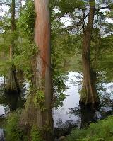 Cypress trees line both banks and the water is usually not quite as clear. Trout are somewhat less abundant from this point on out, but the ones you do catch aren't missing any meals. Some of the nicest rainbows I have caught have been in this stretch. The next couple of miles contains two or three small shoals before you come to Ramsey's Landing. Here you will find the last AGFC ramp and walk-in access in Little Red's trout waters. By now you are far from the dam and the water has warmed quite a bit. Below the ramp is a nice swift shoal that provides some good fishing, but most of the fish are stockers on the small side. While some trout do exist farther downstream from here, Ramsey's pretty much marks the end of the trout fishery. Catches of spotted bass, bream, and even a few smallmouth aren't that uncommon here.
The Little Red is a great place to catch trout on flies and her history has shown that she is capable of growing the largest trout in the world. Please practice "catch and release" and respect the river so she can keep producing "world class" fly-fishing for years to come. |