
home main categories knowledge center cheat codes utilites & add-ons screenshots other sites links building architect the guestbook sign guestbook view guestbook contact contact by form contact by e-mail |
 knowledge center
SimCity 3000 doesn't ship with a separate terrain editor like SimCity 2000 did. You're basically limited to the landscape tools found on the SimCity 3000 toolbar. Unfortunately, these tools can only shape small amounts of land at a time, and boy are they expensive to use. While they are great for quick terrain modifications, they just don't cut it for large-scale terraforming. No fear! SimCity 3000 comes with something even better than SimCity 2000's terrain editor and the not-so-powerful landscape tools in SimCity 3000. SimCity 3000 lets you "paint" your own terrain by importing special bitmaps (a graphics file). Using this method, you can make virtually any kind of terrain you want. This even includes sharp cliffs (almost vertical, in fact!), realistic volcanoes, rivers or even faces! The Bitmap First you need a bitmap that can be imported into SimCity 3000. Here are the requirements for the bitmap:
You can use bitmaps of other sizes, but they may not fill up the entire map (if they're too small), or they will be truncated (if they're too big). How does SimCity 3000 read the bitmap and generate the terrain? Well, think of each pixel in the bitmap representing a tile in SimCity 3000. In effect, it's a grid of the city. Varying shades of gray in the bitmap (ranging from white to black) are interpreted as certain elevation levels. For example, white pixels in the bitmap represent the highest possible level of terrain (2939 meters above water level) and black pixels represent the lowest possible level of terrain (391 meters below water level). The lighter the shade of gray, the higher the elevation. To elaborate, there are approximately 256 levels of elevation in SimCity 3000. Coincidentally (or maybe not), there are 256 shades of gray available in an 8-bit grayscale bitmap (BMP) file. Each of these shades of gray has an associated index value ranging from 0 to 255. The index value of 0 represents black (which in turn represents 391 meters below water level in SimCity 3000) and the index value of 255 represents white (2939 meters above water level in SimCity 3000). The index value of 30 represents the first level of water (water level), with values less that 30 representing greater depth. The index value of 31 represents the land level closest to water level, with values greater than 31 representing greater elevations. To help you chose the correct elevation, SC3000.COM has developed an elevation palette that you can use while generating your bitmaps. All you need to do is load the image below into your paint program along with the bitmap you're working on, and use your "color picker" tool to select the appropriate color for the elevation you want. You can then use your paint program to apply this color to your bitmap with whatever paint tools you're using. 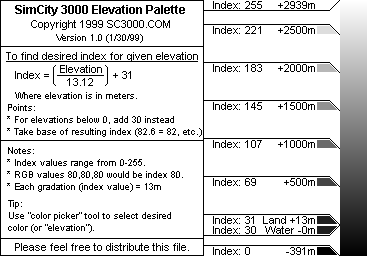 Load It Up, Scotty! Once you have created your bitmap, all that's left to do is to import the file into SimCity 3000:
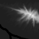
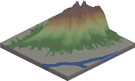
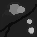
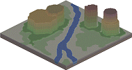
Below are some bitmaps (created in Paint Shop Pro 5 using the paintbrush, soften and smudge tool) and their resulting terrain in SimCity 3000.
Additional Tips Almost any paint program will do as long as it can save 8-bit grayscale bitmaps. If you are using Paint Shop Pro 5, here are some pointers that will make creating bitmaps easier:
Author: Wren Weburg
More Articles
Technical Running SimCity 3000 In A Window How to Minimize SimCity 3000 or Building Architect Tool How PC Users Can Get Colored Cursors Changing SimCity 2000 files into any 3000 files Adding An Extra Song to your Song List Reclaim disk space after BAT installation
Terrain
How To's
Extra |
||