


| Should the death penalty be reinstated? |
Source: Lew Leppan: The South African Book of Records. Cape Town, Don Nelson, 1999.
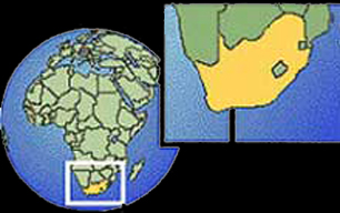
By far South Africa's biggest neighbour is the ocean - or two oceans, which meet at the southwestern corner. Its territory includes Marion and Prince Edward Islands, nearly 2 000km from Cape Town in the Atlantic Ocean.
The cold Benguela current sweeps up from the Antarctic along the Atlantic coast, laden with plankton and providing rich fishing grounds. The east coast has the north-to-south Mozambique/Agulhas current to thank for its warm waters. These two currents have a major effect on the country's climate, the ready evaporation of the eastern seas providing generous rainfall while the Benguela current retains its moisture to cause desert conditions in the west.
Several small rivers run into the sea along the coastline, but none are navigable and none provide useful natural harbours. The coastline itself, being fairly smooth, provides only one good natural harbour, at Saldanha Bay north of Cape Town. A lack of fresh water prevented major development here. Nevertheless, busy harbours now exist at Cape Town, Port Elizabeth, East London, Durban and Richard's Bay.
On dry land, going from west to east, the country shares long borders with Namibia and Botswana, touches Zimbabwe, has a longitudinal strip of border with Mozambique to the east, and lastly curves in around Swaziland before rejoining Mozambique's southern border. In the interior, nestled in the curve of the bean-shaped Free State, is the small mountainous country of Lesotho, completely surrounded by South African territory.
There are only two major rivers: the Limpopo, a stretch of which is shared with Zimbabwe, and the Orange (with its tributary, the Vaal) which runs with a variable flow across the central landscape from east to west, emptying into the Atlantic Ocean at the Namibian border. In so dry a country, dams and irrigation are extremely important: the largest dam is the Gariep on the Orange River.
The total land area of South Africa is slightly more than 1.2 million square kilometres, and it measures some 1 600km from north to south and approximately the same from east to west.
The legislative capital is Cape Town, the administrative capital is Pretoria, and the biggest city is Johannesburg. A good rail and road system links all major centres.
There are nine provinces (follow the links to find out more):
Eastern Cape, Northern Cape and Western Cape in the west and south.
Free State in the central region.
Limpopo and North West in the north and north west.
KwaZulu-Natal in the eastern region.
Gauteng and Mpumalanga in the north east.
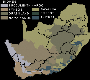
South Africa has seven major terrestrial biomes, or habitat types - broad ecological life zones with distinct environmental conditions and related sets of plant and animal life.
Select A Province
| Eastern
Cape Northern Cape Western Cape Free State Limpopo North West KwaZulu-Natal Gauteng Mpumalanga |
