


| Should the death penalty be reinstated? |
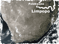
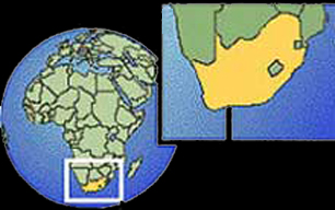
Limpopo
Limpopo province occupies 10.2% of the country's land. Its northern border is the Limpopo River, its northern neighbour Zimbabwe. Mountain ranges include the northern Drakensberg to the west, the Soutpansberg in the north and the Waterberg towards the east.The province is rich in Bushveld and includes the northern part of the Kruger National Park, which itself borders on Mozambique.
It has variable summer rainfall. The far west, bordering on Botswana, is the driest area.
The province's centrally situated capital is Polokwane (previously Pietersburg), which is both on the Maputo Corridor route - a direct link with the Mozambique port - and on the N1 from Johannesburg to the Zimbabwe border at Beit Bridge.
Part of the Great North Road, the N1 also conveniently connects the towns of Warmbaths, Nylstroom, Potgietersrus and, virtually on the border, Messina. Other significant towns are Phalaborwa, Thabazimbi and Tzaneen.
Phalaborwa, on the Kruger Park border, has the world's largest open-cast copper mine; Thabazimbi is an important iron mining centre. Other minerals include asbestos, coal, platinum, chrome, vanadium, nickel, titanium, diamonds, phosphates and gold.
It is a major producer of vegetables, and the subtropical climate enjoyed by much of the province gives rise to the cultivation of tea, coffee and fruit, especially tropical fruit. Forestry makes a major contribution to the economy, as do sunflower, cotton, maize and groundnut crops, and cattle ranching.
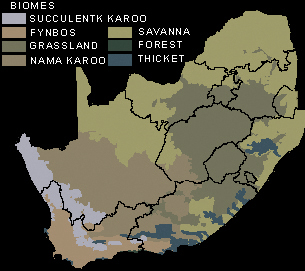
South Africa has seven major terrestrial biomes, or habitat types - broad ecological life zones with distinct environmental conditions and related sets of plant and animal life.
Select A Province
| Eastern
Cape Northern Cape Western Cape Free State Limpopo North West KwaZulu-Natal Gauteng Mpumalanga |