


| Should the death penalty be reinstated? |
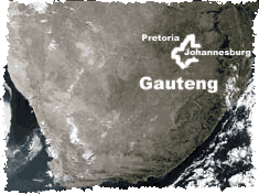
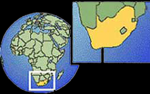
Gauteng
Situated in the heart of the Highveld, Gauteng is the smallest province in South Africa at only 1.4% of the land area, but it is highly urbanised and has the second-largest population (after KwaZulu-Natal).Its southern border is the Vaal River which separates it from the Free State, and it also borders (clockwise) on North West, Limpopo Province and Mpumalanga. It is not only the major urban centre of the northern part of the country but the economic powerhouse of the entire country.
Its capital and largest city is Johannesburg, with virtually continuous urban east and west extensions through many towns including Roodepoort and Krugersdorp on the west and Germiston, Springs, Boksburg and Benoni on the east, a result of development along the immensely rich gold-bearing reef of the Witwatersrand. This reef also yields uranium.
Pretoria is 50km to the north of Johannesburg and the important industrial and coal-mining towns of Vereeniging and Vanderbiljpark about the same distance to the south, on the Vaal.
In spite of its dense urbanisation and large industrial and business sectors, Gauteng has significant agricultural land providing fruit, vegetables, dairy products and meat to the cities as well as areas where maize, groundnuts, sunflowers, cotton and sorghum are grown.
Like the rest of the interior this is a summer rainfall area. Summers are hot and winters frosty.
The Witwatersrand ridge forms the watershed for the Vaal and Limpopo rivers, but Gauteng has no major rivers other than the Vaal. Although the province has important wetlands, drought is not uncommon and it depends on the Vaal Dam for reliable water supplies.
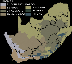
South Africa has seven major terrestrial biomes, or habitat types - broad ecological life zones with distinct environmental conditions and related sets of plant and animal life.
Select A Province
| Eastern
Cape Northern Cape Western Cape Free State Limpopo North West KwaZulu-Natal Gauteng Mpumalanga |