DELI SERDANG
The Regency of Deli Serdang consists of a coastal area (on the straits of Malaka), lowlands, highlands and mountains. Geographically, Deli Serdang is located in the eastern part of North Sumatera between latitude 2 , 57' North and longitude 3, 16' east and has an area of 439.793,5 hectares. With the populations is about 1,6 million, and there are many big plantation companies in this area which have been developed into agro - tourist attractions. The area can be classified into 3 regions ; lowlands at 10-50 meters above sea level, foothills at 50-499 meters above sea levels and highlands at more than 500 meters above sea level. Its boundaries are : Langkat and Malaka Straits in the north , Karo and Simalungun in the south, Asahan and Malaka Staits in the east and the regency of Karo and Langkat in the west. The regency of Deli Serdang surrounds municipalities of Medan, Tebing Tinggi and Binjai municipalities
Sembahe
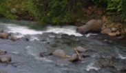
Sembahe is located on the main road to Berastagi, about 36 km from Medan. Lot of visitors come to this place to enjoy swimming in the fresh river water, and eating fresh fruits such as durian, mangosteens, and yellow fruits according to the season. Sembahe is surrounded by thick forests. There are some restaurants in that place.
Bandar Baru
Bandar Baru is located near the sibolangit Camping Ground with its cool and fresh climate. A lot of restaurants and losmen are available. It is a popular weekeend destination for local people from Medan, since it is only about 40 km from Medan and about 16 km from Brastagi. The place can be reached by bus or other local transportation. In addition to the tourist attraction mentioned above, there are a lot of places which are still in the process of development for tourists such as percut, pasir putih, pulau cemara, pantai Merdeka, Lau dendang, Bunga na Bontar, Semanggi, Bendungan Namo Rambe, Lau Gembur, Danau Linting, Paruh Enggang, Makarau, Biru - biru Indah, Taman Dewi, etc.
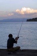
Pantai Cermin (Cermin Beach) & Sialang Buah beach
Pantai Cermin located about 48 kilometers from Medan, faces the Malaka Straits. Tourists can enjoy seafood, fishing and recreation. Pantai Cermin can be reached by public transportation.
Sialang Buah Beach which is about 60 kilometers from Medan faces the Malaka straits, and similar to Pantai Cermin (Mirror Beach). Tourists can enjoy the seafood, fishing or swimming. Sialang Buah beach can be reached by bus or other transportation.
There are huge palm plantations and palm oil processing plants (factories) in this place. These plantations belong to the government, and are about 45 km from Medan. Adolina can be reached by public transportation within one hour.
Sibolangit
& Lapangan Pramuka ( Boy Scout Field )
The Sibolangit tourist garden, which used to be called Sibolangit Nature Preserves, is about 40 km south of Medan, on the road to Karo Regency. It is a protected forest that has many different kind of flora and fauna. There are lots of special palnts in this garden and it is mostly visited by families with the children, students and researchers because of it's wide variety of plants. About 7 km from the Sibolangit Tourist Garden you will found Lapangan pramuka (Boy Scout Field), is also well known as the sibolangit camping ground. The 1977 National Jamboree was held out in this place, and was attended by Scouts and leaders from all over Indonesia and other ASEAN countries. Tourist can enjoy the fresh and cool air while camping in the area. Local transportation is available to get to this place.
Deliserdang