OVER THE HUMP
By Wally Kulikowski
An experienced spoonplugger is well aware of
the role major features such as bars or points have in successful
fishing. He knows they are essential to "fish migration" and they
should be fished accordingly. He is also mindful of the fact that
smaller structures such as "humps" need to be duly noted, and that
they also can play a vital role in locating fish. Often times
these smaller less obvious features are not shown on contour maps,
leaving them virtually untapped by many unsuspecting fishermen.
Depending on how and where they are situated, humps such as these
can produce diverse species like; northern pike, walleye,
smallmouth & largemouth bass, and can contain "schools" as
well as stragglers under certain weather conditions. How does one
go about finding these smaller features, especially when they are
not recognized on contour maps? Citing an example will give you a
better idea of how this can occur.
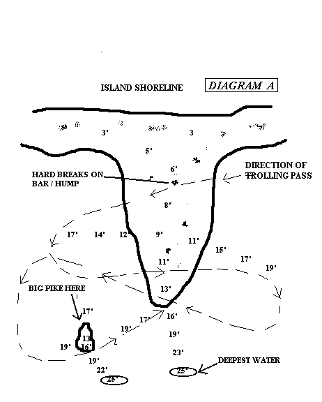
My partner and I were mapping a bar (diagram A)
located between two islands. It was a medium sized feature
situated in such a way that wide turns with the boat were
necessary to hit the tip of the bar correctly from different
angles. On the second trolling pass I swung the boat around
setting my sights on the marker buoy placed near the tip of the
bar. As I came approximately ten yards from the buoy, my partner
told me he was ticking bottom. It wasn't soon after he made that
statement his rod doubled over from the weight of a large northern
pike. His lure had inadvertently located a small hump located out
in deep water situated about fifteen yards from the bar we were
mapping. The illustration below depicts how the sequence of events
occurred.
DIAGRAM A
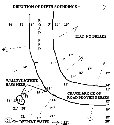
This incident was by no means isolated, nor was it
confined only to natural lakes. While mapping a roadbed in a man
made lake that was located closer to home, a similar experience
occurred.
With the aid of my depth finder I had already established the
general shape of a roadbed and proceeded to take soundings going
off the feature, so as to determine where the sharpest break to
the deepest water was occurring. While noting these soundings
(Illustrated in diagram B) the sharper breaks and deepest water
were identified, as well as a small hump. All three
characteristics were located in the vicinity where the road made a
turn of approx. ninety degrees, warranting further checking of the
area on subsequent outings. It wasn't until the following year
(seasonal movements) that this hump proved to be highly productive
for walleye.
(FIGURE B)
Similar incidents have reoccurred several times in my
fishing experiences. In all cases proper presentation of lures and
or observing depth soundings off the major structures identified
smaller or secondary features located in the vicinity. At no time
did I go out of my way and spend countless hours running around
the lake looking for these smaller structures with my depth finder
or lures, nor would it be wise to do so. Working the major
features we can identify in the proper manner, i.e. lure
presentation/soundings can be just the prescription to put us
"over the hump."
TOP
OF THE PAGE
RETURN TO HOME
PAGE