The Hole Story
(Beyond The Basics - Part II)
By Wally Kulikowski
When contemplating the presentation of lures at or
near sanctuary depths, efforts must be targeted at specific areas
where prospects for fishing success are most promising. Our focus
would primarily be directed towards those areas that have shown a
level of productivity during the warmer part of the season. Such
information provides important leads as to the vicinity of "where"
deeper" our efforts should be concentrated. Let's quickly
"profile" some of the characteristics a favorable structure would
possess, especially when presenting lure by casting or slow
trolling in or at "sanctuary depths."
1. Structures that contain " definable" features
"deep"… even down to sanctuary depths. - Remember, structure
is always our guideline, especially when probing into "the deepest
waters." Otherwise, we are better waiting at shallower depths for
fish activity.
2. Structures that are isolated in nature and not subject to
high winds if possible. - The ability to maintain an anchoring
position is crucial, we must be sure to work these waters
carefully with tighter fan-casting. Otherwise, slow trolling may
be optional.
3. Structures that are relatively "small in stature" as
compared to larger features. - This is primarily due to the fact
that when probing depths of 30ft.or deeper by casting, we are
confined to the "limited distance" this type of presentation
imposes on us, resulting in numerous anchoring positions and
thereby becoming a "daunting task" as well as " impractical" when
fishing large features.
Figure (A) represents a "favorable structure situation,"
for fishermen when weather & water conditions dictate the need
to present lures in or near the sanctuary depths. The numbers
always tell the story!
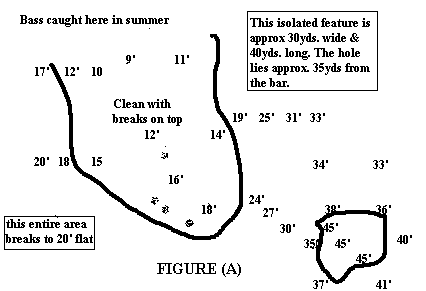
NOTE: Converting this feature to a "side view"
will enhance your interpretation of its "defined" features into
the sanctuary depths.
When probing "the deepest" sections of any given lake, having
the "proper tools" is absolutely essential to achieve a "thorough
testing" of these depths. Such equipment consist of; 75ft.of
anchor rope, ¾ to 1 1/2 oz. weighted jump baits, marker
buoys-60ft.line (heavy weights), as well as casting rods &
reels etc.
Diagram (B) will illustrate techniques that I, as well as
other spoonpluggers have incorporated throughout the years to make
contact with fish at these depth levels.

Before working down into "sanctuary depths," it is
important the shallows be eliminated in proper fashion, then the
top part of the bar, as indicated by the "casting positions" on
the map. As we work deeper, our fan casting would increase in
number, from 6 to 12 per anchoring position. Also, we would cast
all around the boat, and in a tighter pattern (closer together)
Two types of lures that have been productive for myself are, blade
baits, spoons, and live bait rigs. I would not hesitate to try a
"Carolina rig" as well. If bottom conditions are soft, (muck) a
floating type lure presentation off the bottom might be
effective.
I have also found "slow trolling" with a controlled throttle
or trolling motor is effective, " especially when used with live
bait. Working from the marker in a straight line outwardly will
cover these deep areas (note general arrow directions on map) Your
approach to fishing situations such as these must be methodical in
every respect. You must be aware of where you are casting at all
times, where your last anchoring position was, and how far of a
distance your actually covering, considering the depths your lure
must descend.
During the "late fall" fishing lakes that have the right
structural characteristics can be productive for largemouth, white
bass, walleye, pike, and other species, provided you know the
"hole story " on fish movements.
RETURN TO
HOME PAGE