 | ||||||
| Articles | Projects | Resume | Cartoons | Windsurfing | Paintings | Album |
Esquimalt Lagoon
State of the Ecosystem Report
Water Quality Analysis Project 1998
Waterose et. al.

Section 11. Future Study Options:
Septic Drainage Project
Coliform Loading Project
Geomorphological Deposition Project
Expanded Water Sampling Project
The findings of this report are preliminary in nature and provide an opportunity for future environmental science learners to build upon. There are many possible areas that merit study in greater detail. Based upon the findings of this project, the following are suggested as interesting and exciting avenues of exploration.
Septic Drainage Project:
RRU should perform an in-depth study of the existing septic and drainage systems on the south-western part of the property. There is a possibility that septic leakage is occurring near the CEDAR and Mews buildings. This could be incorporated with further study of surface waters in the area, to help pinpoint potential sources. Communication should be developed with the family resource center on this issue, as this study indicates the possibility of fecal coliform inputs in that area. A further study could include analysis of samples from Bee Creek, which flows through the resource center�s property. A sampling regime has been suggested in section 21.1 that accommodates these factors. As well, it considers the time and budget allowance of an environmental science major project.
Coliform Loading Project:
Further study could investigate the significance of migratory bird impacts on the Lagoons� water quality. This study would involve assessing the fecal coliform loading potential of each avian species, the numbers of each that utilize the lagoon and for what duration they are present. As well, it could investigate the role of sediment and sea wrack in facilitating high levels of fecal coliform in the Lagoon.
Geomorphological Deposition Project:
An in depth study of the active deposition of Coburg Peninsula could be performed, with particular reference to the Metchosin Gravel Pit as a material source. This would provide information regarding the feasibility of opening a second inlet to the Lagoon to increase tidal flushing. One source of information on this topic are historic air photos. There are yearly air photos of Esquimalt Lagoon dating back into the 1940s. Changes in deposition along the spit, and off Fort Rodd Hill, can be mapped over time from the historic air photos. Evidence of active sediment transport, and its rate, from the Gravel Pit area could also be assessed by tracking the movement of colored stones planted on the foreshore. There are also many ecological implications of opening a second tidal inlet to the Lagoon. These could also be incorporated into such a study.
Expanded Water Sampling Project:
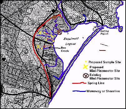
Testing should be done in the western part of the property moving upstream from sites five and six towards the spring line at the base of the hill, inland from the Lagoon. A site could be maintained near the springline and close to the source of a particular creek of study. The data from that site could be compared with data taken from a site that is systematically, over time, moved up the creek, beginning at the mouth. This could help to determine the origins of the high nitrate concentrations and fecal coliform counts in this area. This strategy could also be applied to Bee Creek. Bee Creek runs through the property of the family resource center, but has its origin on RRU grounds. Co-operation with the center should be pursued in this regard. See Figure 20 for a graphic representation of these potential sites.It would also be useful to perform fecal streptococci testing which can differentiate between human and non-human coliform counts. This will require the purchase of special materials.
The installation of mini-piezometers at or near the springline, and near the Lagoon, would allow further data to be collected about the condition of the ground water. This data can be used to determine what, if any, changes to the water as it flows through the property. Ideally, this should occur on the south-western portion of the property, where human activity is at a minimum. The existing mini-piezometers could be used to continue sampling groundwater near the Garden Creek system. However, the upper one, known as site eight, should be moved downslope on the south side of the road, as at times it was difficult to obtain a water sample from its� present location. As well, the one at site seven should be tested for salinity levels to assess whether salt water intrusion from the Lagoon has occurred at that site. See Figure 11.1 below for the potential locations of mini-piezometers.
Future study could involve one or a combination of these suggestions. The information researched and obtained in this study has provided a basis for further investigation. The Environmental Science Program emphasizes the practice of environmental sustainability. This project, if continued, will help RRU to realize its goal of continuous improvement with regard to the sustainable management of its� land base.
To Section 12. References
Index:
- Introduction
- History and Land Use
- Geomorphology
- Nutrients and Coliforms
- Red Tides and Fish Kill
- Hydrocarbons
- Sample Procedure
- Analysis Procedure
- Results
- Discussion
- Future Study
- References
- Photo Album


 email Waterose
Please Sign My Guestbook
Please View My Guestbook

| Articles | Projects | Resume | Cartoons | Windsurfing | Paintings | Album |
 | ||||||