 | ||||||
| Articles | Projects | Resume | Cartoons | Windsurfing | Paintings | Album |
Esquimalt Lagoon
State of the Ecosystem Report
Water Quality Analysis Project 1998
Waterose et. al.

Section 2. History and Land Use:
Background of Esquimalt Lagoon
Historical Land Use
Land Use Today
City of Colwood
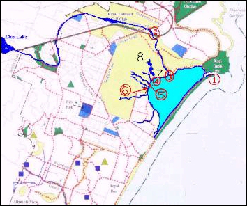
Figure 2.1 Colwood Drainage Basin
The Royal Colwood Golf and Country Club
Background of Esquimalt Lagoon:
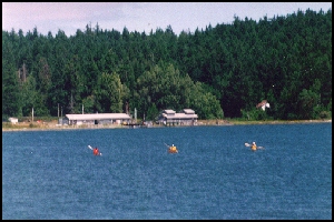
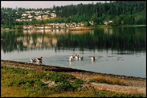
Esquimalt Lagoon is located just east of Esquimalt Harbor near the southern tip of Vancouver Island. RRU occupies the largest single land base adjacent to the Lagoon. The topography of this land is characterized by rocky slopes to the north, and gravel slopes to the south end of the Lagoon. The soils are composed of permeable glacial tills, sand and gravel (Colwood, 1997). The Environmental Mission Statement of RRU reflects the desire to manage the campus in an environmentally responsible manner (Watchell and Thompson, 1997). The concerns regarding Esquimalt Lagoon pertain to the recreational use of the Lagoon. The present and potential anthropogenic uses of the Lagoon include swimming, boating, fishing, and site seeing. As an estuary, it provides an important habitat for a diverse community of marine and terrestrial flora and fauna.There are several factors which affect the recreational values and the intrinsic habitat values. The most immediate human health concern is a high concentration of fecal coliforms. Fecal coliform analysis of Lagoon water samples, provided by John MacRae & Associates Inc. in August of 1997, indicated levels as high as 25200CFU/100ml (CFU = Coliform Forming Units) (MacRae et.al., 1997). The maximum acceptable concentration for areas of �primary contact�, swimming, is 100CFU/100ml, and for �secondary contact�, boating, is 200CFU/100ml. In addition to monitoring fecal coliforms, certain nutrients such as nitrates are also monitored to analyze the general health of water bodies. Some of the freshwater inputs into the Lagoon have been determined to have concentrations of nitrates which exceed the maximum acceptable levels (Canadian Council of Ministers of Environment (CCME) freshwater guidelines). Although the cause of this phenomenon is not completely understood, there is a potential correlation between the coliform levels and the nutrient levels. Another phenomenon related to high levels of nutrients was an algae bloom in 1990, which caused a major fish kill (Colwood, 1993). A similar fish and crab kill that occurred in August 1997, was suspected to have been caused by anoxic water rapidly brought from the bottom layers of the Lagoon to the surface by a �rollover� event (Young, 1997).
There are several approaches that can be taken in assessing the problems associated with the water quality in Esquimalt Lagoon. Some examples include a complete nutrient budget, a sediment analysis, a benthic invertebrate study, a study of red tide bloom triggers, an analysis of total/fecal coliform inputs, and a survey of the hydrology and landforms surrounding the Lagoon.
The approach that was adopted for this study was to develop a strategic sampling plan to encapsulate the analysis of surface water that originates above ground both on and off the RRU property and to draw comparisons. In addition, the chemical analysis approach that was adopted was to develop testing techniques that could be completed in-house within a reasonable amount of time and cost. The objective was to obtain a broad overview of the levels of nutrients and fecal coliforms in the RRU water systems. With this information, potential areas of concern were identified for analysis in further detail at a later time.
Historical Land Use:
Historical Land Use Summary:
The chronological history of the land use is summarized below. This background information provides valuable insight into the historical significance of RRU and identifies the record of land uses.
- Specific Date unknown. The Straights Salish Natives (Songhees) had a settlement prior to the arrival of the Europeans. Archaeological Sites document the evidence of the native occupation. The Natives also had a burial ground where they placed their dead in boxes and hung them in the trees of Hatley park on the north shore of the Esquimalt Lagoon approximately 450 meters east of the mouth of Cottonwood Creek. The Songhees Band currently have unresolved land claims in the Hatley Park area. This was confirmed by the Band�s attorney (Woodhouse, 1998). The Songhees Band have interests and claims that should be addressed before any transfer of land title between the federal and provincial jurisdiction can be completed.
- 1851. Captain Edward E. Langford arrived from England to assume managership of Esquimalt Farm.
- 1863. A sawmill was established on what later became Hatley Park.
- 1871. BC entered the Confederation and became Canada�s 6th province.
- 1858. The Fraser River gold rush started and the population of Fort Victoria increased from 300 to approximately 20,000 within 6 weeks. The population eventually declined to approximately 6,000.
- 1886. The Dunsmuirs built the Esquimalt and Nanaimo Railway.
- 1892. Roland Stuart built the Hatley Park Home that overlooks the Esquimalt Lagoon. The Dunsmuirs moved into their new home that overlooked the Gorge.
- 1900. James Dunsmuir became Premi�re of BC.
- 1905. Hatley Park was destroyed by fire.
- 1906. James Dunsmuir was appointed Lieutenant-Governor of BC.
- 1908. The construction of Hatley Castle was initiated.
- 1931. King George V sanctioned the prefix �Royal� for the Colwood Golf and Country Club although this was not official until 1936. Great Britain proclaimed complete autonomy for Canada.
- 1940. Hatley Park estate was purchased by the Canadian Government for $75,000.
- 1941. The Naval Officer Training Establishment officially opened at Royal Roads.
- 1995. The Royal Roads Military College closed.
- 1995. The Royal Roads University was established.
Some Colourful Details about the Historical Characters:
- June 1790. Manual Quimper and Gonzalo Lopez de Haro (�Captain Arrow�) sailed into the Strait of Juan de Fuca. They anchored at both Sooke and at Royal Roads where they erected wooden crosses and claimed the land for Spain. Royal Roads was named Rada de Valdes y Bazan but the name was changed to Royal Bay in 1846.
- March 28, 1795. The Spanish flag at Nootka was replaced by the British flag. Then, in compliance with the terms of the Convention, the Spanish fort was dismantled and the Spanish garrison returned to Mexico. This ended the Spanish influence in the area.
- 1843. Fort Victoria was established. It was from this British outpost that the settlement spread outward to Metchosin, Langford, Happy Valley, Glen Lake and Colwood. Under a colonization agreement, between the Hudson�s Bay Co. and the British government, Captain Walter Colquhoun Grant became the first independent settler to come to Vancouver Island. His servants arrived in Victoria in June, 1849. When Grant arrived, he decided to locate in Sooke.
- May 10, 1851. The sailing ship, the Tory, brought the first English family to the Fort. Captain Edward E. Langford managed one of the four company farms of the Puget�s Sound Agricultural Company. Langford took over supervision of 600 acres of Esquimalt Farm. The boundaries ran from Paterson Point, due south of Cole Island, to the north-east corner of the Hatley Park estate. The farmhouse was called Colwood, named after Langford�s Sussex residence. The farm produced less than the owner would have liked because Langford was not a successful administrator. Another part of this land contained a sawmill operated by John Gilmore. The logs were hauled to the mill by oxen along a skid road which led from Sooke Road through the woods to the Lagoon. The mill provided work and lumber for the residents of the area from 1863. In the early 1870�s the mill was converted into a tannery and shoe factory. The Muir brothers purchased the Grant property. They purchased hemlock bark from Sooke which was used in the tannery. Muir Creek was the source of most of this bark that was hauled by cows to Esquimalt. From there, it was transferred to Indian canoes and taken to the tannery. Each year approximately 400 tonnes of bark were ground and used to tan the leather. Subsequently, oak bark was imported from California to be used in the tannery.� The tannery was located at the end of a stream and was operated by a water wheel.
- Hatley Park 1900�s. Roland Stuart was the owner of Hatley Park. Belmont Road was one of the boundaries which was traversed by a trail that led through the woods and crossed a stream into an area called Ravensdale. Ravensdale was the site of a beautiful waterfall, �The Sprite of Ravensdale� on Colwood Stream. Mr. Roland Stuart supplied the navy ships with fresh water which was piped from a spring stream on the property to Belmont. Stuart sent samples of the water to London for analysis and there they found this water to be absolutely pure and fit for navy use. The property was cultivated for farming. They raised livestock, including horses, cattle and sheep which were used by the Navy. Robert Dunsmuir was born in Hurlford, Scotland in 1825 where he was raised by his uncle, Boyd Gilmour. Robert and his spouse, Joan Olive White, moved with his uncle Gilmour to the New World to Fort Rupert on the north-east coast of Vancouver Island. These men contracted with the Hudson�s Bay Co. to develop the coal-mining venture in Fort Rupert. Robert Dunsmuir was the founder of family fortune which enabled his son, James, to build Hatley Castle.
- 1907. Roland Stuart sold 250 acres to James Dunsmuir that were part of Stuart�s Hatley Park. Roland Stuart announced that he intended to leave Vancouver Island and James Dunsmuir, serving as Lieutenant-Governor of BC, paid $50,000.00 for possession of Hatley Park.
- 1908. James expanded the estate and added 250 acres and constructed Hatley Castle. The old Colwood Hotel housed some of the stonemasons who built the Castle.
- 1909. Dunsmuir was released from service in public life December 11, 1909. Having satisfied his wife�s desire to be chatelaine at Government House, Dunsmuir made arrangements early in 1910 to sell his mining interests. He was beginning to appreciate Hatley Park life, and continued to enjoy his yacht. He was the 1st honorary commodore of the Royal Victoria Yacht Club, and the displacement of �Dolaura� yacht helped the club to accumulate sufficient tonnage to pave the way to receive regal permission for the prefix �Royal� to be used.
- 1910. By this year, Hatley Park encompassed almost 800 acres. The land use included: a dairy, a stable, a slaughterhouse, a smokehouse, a refrigeration plant, and a glass conservatory. There was a large Chinatown hidden in the trees from the view from the main house. This Chinatown was large enough to accommodate the laborers required to weed the gardens, thresh the grain, collect the eggs, milk the cows, harvest the crops, and, to turn Hatley into a profitable working farm. There is speculation that the location of Hatley Castle was selected by Mrs. Dunsmuir. She was attracted by the woodland setting, open meadowland, waterfalls, and the tall arbutus trees adjacent to the chosen site. The property sloped down to the seashore and the view encompassed a large Lagoon and the panoramic mountains across the strait.
- 1913 - 1916. Dunsmuir commissioned landscape architects to design the general plan for the Hatley Park estate. The landscape plan included the formal gardens at the main house and the development of a model farm. Some of the features of the plan are described as follows: The slope gradients were modified adjacent to the house which improved the spatial transitions between the buildings, gardens, and the fringe of the surrounding Spruce forest.� Down by the Lagoon, a dozen Lombardy Poplars served as windbreaks from the stiff ocean breezes. They also constructed a garage and stable which were one and a half stories high. The second story provided living accommodations for staff and the complex had two wings with courtyard area within the gates. Gas pumps were added to the infrastructure of the estate.
- The creation of �Fountain Court� extended the recreational area into the woods. Two paths from the court led strollers through the �controlled� naturalism of the woodland scenery to the �Falls� and past thick hemlock groves. A formal Italian garden with a pavilion, pergolas, a vine-covered gazebo and gravel paths were constructed. A garden conservatory was constructed. The large greenhouse was constructed and the fruit orchard was laid out in a symmetrical pattern around the greenhouse. They also maintained vegetable gardens. Less grandiose, there was also a secluded rose garden for more private moments.
- A croquet court and tennis courts were added for recreation. The pasture fields and hayfields stretched down to the Lagoon. The dairy building housed ten cows and three silos were built on the dairy site. The ice house and the barn formed part of this complex. The house contractor was Thomas Catterall. Smaller buildings included the dog kennels, pig pens, ice house, smoke house and buildings for the Chinese workers.
- Water has played a major role in shaping and development of Hatley Park. On a larger scale, the old reservoir and the drain that divided this agricultural area of the estate from the main house was reconstructed to form a pool in the center of the walled rose garden. It was then drained off to form several brooks which meandered down to the Lagoon through three large ponds and connecting waterfalls; these are still some of the main features of the Japanese gardens. The different pools in the Japanese garden were interconnected with fish ladders so that the trout and salmon could swim unhindered through the entire course of this waterway. The banks of the ponds were planted with native flowering trees, shrubs and herbaceous plants. This was fringed by natural woods and foraging cattle.
- The construction of the extensive granite wall with iron gates deterred trespass by outsiders from the Sooke Road. On the water side of the estate, in the early days, all visiting British ships called at Rodd Hill for their water supplies, which originated from springs on the south side of the property. � The discovery of a valley with a waterfall and many dogwood trees was responsible for Mrs. Dunsmuir�s initial interest in the property with its mile of waterfront. The main gate lodge, known as the Belmont, was constructed of a mixture of granite, blue rock and half timber. The Belmont was never used for its intended purpose. In 1913 it became the residence of John Graham, Mr. Dunsmuir�s manager for the estate. Later, it was used as the headquarters of the Colwood Detachment of the Royal Colwood Mounted Police.
- 1936. The official name of the �Royal� Colwood Golf and Country Club was granted.
Land Use Today:
City of Colwood:
The study examined areas both within and outside the RRU property in order to draw comparisons. Of particular interest is the origin and source of Colwood Creek. Glen Lake is the source of Colwood Creek and runs through the Royal Colwood Golf Club and the grounds of the university into the Lagoon. Glen lake and the ponds in the Golf Course are used heavily by waterfowl, and are surrounded by residential neighborhoods. Colwood City surrounds the grounds and inputs from Colwood may be draining through the RRU property through the water table. Until recently, all residences in the Colwood area used individual septic systems. In addition, there is a sewage outfall used by RRU that extends 400 meters south of the Lagoon out into the ocean.The Colwood area drainage basin, which flows into the Esquimalt Lagoon is illustrated in Figure 2.1 below.
The Royal Colwood Golf and Country Club:
The information regarding the upstream land use has been compiled from previous reports and interviews with the staff of the Royal Colwood Golf and Country Club.The land area totals 150 acres including 100 acres of turf and 50 acres of woodland. This includes 18 play holes, one lake and two ponds. Glen Lake is the source of the surface drainage water which flows through the golf course and into the Esquimalt Lagoon via Colwood Creek. The golf course land was used as a gravel pit and was later topped with sand. Sand is a porous material, and the golf greens drain naturally through the porous soil. There are natural springs on the grounds. At the second tee the flow rate is 600 gallons per minute. The thirteenth and fourteenth hole have natural drainage (Singlehurst, 1998).
The irrigation system uses water from Colwood Creek. The peak irrigation time is during the summer when they use 4,030-500,000 gallons on per night, depending on precipitation levels, to irrigate the golf course. They experienced an algae bloom at the thirteenth hole in 1996. They obtain soil reports bi-annually. The fairways and greens are predominately black loam soils. The greens are trimmed daily in the summer months, and weekly in the winter months.
The grounds are fertilized by a hopper system with a capacity of twelve to fifty pound bags. They use slow release fertilizers, usually nitrogen and phosphorous, on a one to one ratio. Fertilizers are applied to the greens between March and October, and to the fairways three or four times per year.
To Section 3. Geomorphology
Index:
- Introduction
- History and Land Use
- Geomorphology
- Nutrients and Coliforms
- Red Tides and Fish Kill
- Hydrocarbons
- Sample Procedure
- Analysis Procedure
- Results
- Discussion
- Future Study
- References
- Photo Album


 email Waterose
Please Sign My Guestbook
Please View My Guestbook

| Articles | Projects | Resume | Cartoons | Windsurfing | Paintings | Album |
 | ||||||