 | ||||||
| Articles | Projects | Resume | Cartoons | Windsurfing | Paintings | Album |
Esquimalt Lagoon
State of the Ecosystem Report
Water Quality Analysis Project 1998
Waterose et. al.

Section 3. Geomorphology:
Geomorphology of the Drainage Basin
Figure 3.1 Geology of Esquimalt Lagoon Drainage Basin
Coburg Peninsula
Geomorphology of the Drainage Basin:
The drainage basin of Esquimalt Lagoon comes from a highly dynamic geologic background. The Colwood delta covers much of the area in gravel that was spread out by meltwater streams that discharged into the ocean, just north of Albert Head. This occurred when the ice from the Fraser Glaciation receded from the area, about thirteen thousand years ago. A large stagnant chunk of ice, approximately one hundred meters thick, likely occupied the present site of the Lagoon. This ice forced the meltwater streams around it, and consequently, their gravel load as well. This created the present basin, where the Colwood delta ends on RRU property, creating a steep hillside. Below this hillside, and around the Lagoon, the substrate is composed mainly of Victoria Clay. This clay accumulated around southern Vancouver Island at the end of the Fraser Glaciation. On the north-eastern side of the Lagoon, the shoreline is composed mainly of outcroppings of much older volcanic Wark Gneiss (Yorath & Nasmith, 1995). These geological features are illustrated in Figure 3.1 below.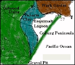
Coburg Peninsula:
Coburg Peninsula was formed when sand and gravel was eroded from the Colwood delta deposits located just south-west of the Lagoon, and then transported north-east by longshore currents. The sand and gravel was then likely deposited along the large stagnant ice block that remained, thus creating the Peninsula. When the ice block melted, it left behind an already virtually enclosed kettle. This created the Lagoon, with a narrow channel at the north-east end of the Peninsula, at what is known as Gotha point (Yorath & Nasmith, 1995).Little is known about the continued deposition on and around the Peninsula. An oral report claims that at one time there was a second tidal channel into the Lagoon near the south-west end of the Lagoon. The channel was dredged to keep it open due to constant sedimentation that filled up the channel (Turner, 1997). However, the existence of this channel could not be confirmed by any other source. There is some interest to re-open the channel, but the feasibility depends on the sedimentation rates over the long term. A second channel would increase tidal flushing of the Lagoon, but it would also change some of the characteristics of the estuarine ecosystem.
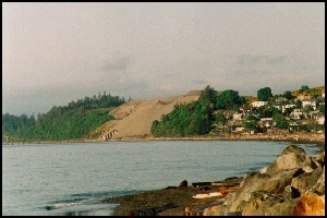
The Metchosin Gravel Pit is located near the water�s edge, on the Colwood Peninsula. It is not known if it contributes to the sediment loading of Coburg Peninsula. This facility is set to be decommissioned in about five years. This facility, viewed from afar is illustrated in the header of this page, and a closer view is illustrated in Figure 3.2 below.
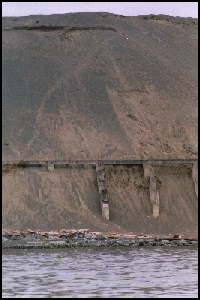
Figure 3.2 Metchosin Gravel Pit
To Section 4. Nutrients and Coliforms
Index:
- Introduction
- History and Land Use
- Geomorphology
- Nutrients and Coliforms
- Red Tides and Fish Kill
- Hydrocarbons
- Sample Procedure
- Analysis Procedure
- Results
- Discussion
- Future Study
- References
- Photo Album


 email Waterose
Please Sign My Guestbook
Please View My Guestbook

| Articles | Projects | Resume | Cartoons | Windsurfing | Paintings | Album |
 | ||||||