 | ||||||
| Articles | Projects | Resume | Cartoons | Windsurfing | Paintings | Album |
Esquimalt Lagoon
State of the Ecosystem Report
Water Quality Analysis Project 1998
Waterose et. al.

Section 7. Sample Procedure:
Sample Design
Sample Sites
Photographs of Sample Sites
Sample Procedures
Interesting Field Observations
Sample Design:
The overall objective of analyzing surface water quality was to determine if there were significant contributions of nutrients and/or coliform inputs from RRU property into Esquimalt Lagoon. The sampling sites were selected to allocate the time and money available as efficiently as possible to meet this objective.There is no existing data from tests on the possibility that effluent from the sewage outfall, which extends 400 meters off-shore from Coburg Peninsula, contributes nutrient and fecal coliform inputs to the Lagoon. For this reason it was decided to locate sampling Site one at the Lagoon�s inlet.
Based on data that had been previously obtained, the sites were selected that could provide additional information about possible sources of inputs.
It was also decided to sample groundwater from two site locations. The tests on the groundwater from the base of the escarpment, near the spring line, provided some indication of the level of nutrients in the ground water as it entered the property. This data was compared with data from another location near the Lagoon.
Sample Sites:
The location of the sampling sites are illustrated below in Figure 7.1. There were six surface water sampling sites and two groundwater wells which are labeled seven and eight on the map.
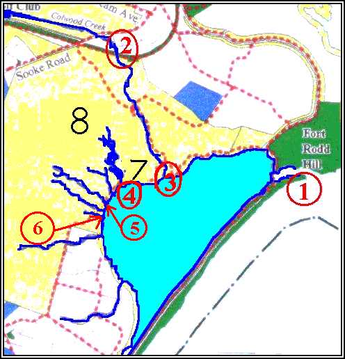
- Site one was located at the mouth of the inlet to the Lagoon. The samples were obtained during the incoming tide to detect if there was any back flushing that may have originated from the sewage out-fall pipe.
- Site two was located upstream on Colwood Creek where it entered the RRU grounds.
- Site three was located downstream on Colwood Creek immediately upstream from the salt marsh and estuary. The sampling was done on the upstream side of the foot bridge. This enabled results from upstream and downstream on Colwood Creek to be compared to detect any significant differences that may indicate inputs from RRU. In addition, these results were compared to those of other surface streams that originated on the university property.
- Site four was located below the ponds where Garden Creek entered the Lagoon to examine levels and potential inputs that may have originated in the Japanese Gardens and the ponds. It is important to note that this system is used by waterfowl, and, it is highly eutrophic.
- Site five was located at the mouth of Hatley Creek where it entered the Lagoon.
- Site six was located at the mouth of a small unnamed creek where it entered the Lagoon, adjacent to the community resource center. Collectively, sites four, five and six provided a good representation of surface waters that emerged on the university grounds.
- Site seven was a small ground water well, known as a mini-piezometer, located below the ponds, adjacent to the Lagoon.
- Site eight was a second piezometer located above the ponds near the pool and gymnasium buildings. The piezometer sites were located above and below the Garden Pond system. The nutrient data from the groundwater was compared to the analysis of the levels in the surface waters in the Pond system. As well, it provided information on the groundwater that emerged along the spring line at the base of the escarpment. This was compared to groundwater near the Lagoon at Site eight.
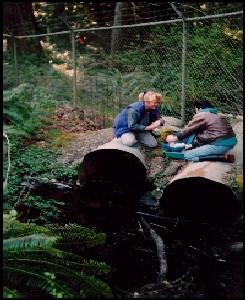
Photographs of Sample Sites:
The photographic representations of the sites are compiled in Appendix A.
Sample Procedures:
Surface water and ground water samples were obtained during the period between January and June, 1998. Duplicate samples were collected from each site in containers that were autoclaved. The field tests included water temperature, pH, and conductivity.The pH/Temperature meter was a model BARNANT30 digital pH (ATC) electro-chemical meter. The pH range was pH 0.00 to 14.00. The precision of the meter was +/- pH 0.01 and +/- 0.5� Celsius for Temperature. The meter was calibrated in pH 4.00 and pH 7.00 solutions at room temperature. The temperature measurements that were obtained with the electronic meter were confirmed with second temperature measurements that were obtained with a standard glass vacuum thermometer.
The conductivity meter was a model 1481-60 digital unit which measured ions in solution. It functioned with an automatic temperature compensator. It was calibrated to 0.670 micromhos, for range 200, at 10�Celsius for the freshwater sites with the 84mS solution.
The instruments had to be calibrated differently for taking readings at Site one, the inlet, due to the salinity of the water. For this site, the conductivity meter was calibrated to 0.504 micromhos, for range 20,000, at 25.0� Celsius with a brine solution.
An electric pump was used to draw water samples from the mini-piezometers. First, the water that had accumulated in the wells was purged. Then, after the wells had recharged with fresh water, the water for the samples was pumped out. The same field measurements were completed for the groundwater samples as for the samples of surface water.
There were some limitations experienced in the field with regard to the collection of field data. For example, the conductivity readings obtained at Site one exceeded the detection limits of the conductivity meter. This was likely due to the high salinity of the water. There may have been some intrusion of saline water from the Lagoon into the mini-piezometer at Site seven.
Interesting Field Observations:
The field team documented some interesting field finds over the last year. Some of these included:
- Juvenile fish were observed in several of the creeks on the property; however, the species were not determined.
- There were large, broken, relic, red clay tiles from the original drainage system in Hatley Creek on the west side of the property, just downstream from the gravel road to the former pasture.
- An intact deer skeleton was discovered near site five in the lower flood plain, east of the former pasture. The skeleton was evidently old, as the bones were smooth and covered with moss.
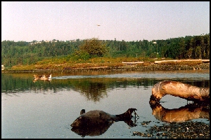
- A dead dolphin was observed on the Lagoon beach just inside the inlet. There was no visible cause of death.
- During the spring, high density flocculates of algae growth were observed in the Lagoon adjacent to RRU grounds.
- Fluids, with characteristics similar to oils, were observed leaching into the Lagoon and the middle pond.
- A recent occurrence of �pink slime� in the Lagoon water was observed in July, 1998 off the boat jetty. Samples were collected, but were not analyzed.
To Section 8. Analysis Procedure
Index:
- Introduction
- History and Land Use
- Geomorphology
- Nutrients and Coliforms
- Red Tides and Fish Kill
- Hydrocarbons
- Sample Procedure
- Analysis Procedure
- Results
- Discussion
- Future Study
- References
- Photo Album


 email Waterose
Please Sign My Guestbook
Please View My Guestbook

| Articles | Projects | Resume | Cartoons | Windsurfing | Paintings | Album |
 | ||||||