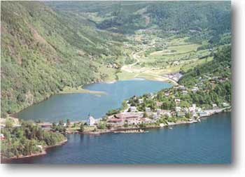
The name "Haus" seems to originate from "head" (the head of a person). Local people are saying that when they are approaching "Haus" by boat and are looking towards "Haushovden" where the school is located, the contours of the terrain look like a head. So, "Haus" got its name from these people arriving by sea.
Since the old days, "Haus" has always been a hub for the travel through
"Soerfjorden". People that
traveled from villages located
further within the fjord and
were on their way to Bergen
either by rowing or sailing
their boats, utilized "Haus"
as a resting place.
The name "Mjelde" has to do
with the sandy, and clay rich
soil in the area.
"Mjeldalen" has always been
a good farming area. The
nature is very beautiful
around "Haus". Various
mountains are surrounding
"Haus" and "Mjeldalen". The
locations "Straumen" and "Mjeldalsvannet" are evidence that the glaciers during the ice age carved out the countryside in a very special and eye catching way.
People have been living in "Haus" and "Mjeldalen" for a very long time. There is solid evidence of this from the various excavation sites in "Mjeldalen". A total of seven old grave sites have been excavated so far. For example, more than 170 years ago a copy of a roman gold medallion was found at one of the gravesites at "Midt-Mjelde". Another item that has been found is a "flintsigd" originating from the Stone Age. This item was not found in a grave, but it indicates that grain did grow here at that time.
Also in "Mjeldalen" the farming houses were located in a very close proximity to each other, and this can be seen to day at "Havraatunet". The houses in "Nedre-Mjelde" were all located between the old house belonging to the "county farm" and the main building at "Hansdalsgaarden". At "Midt-Mjelde" the old the houses were located straight across the road from the youth complex, and even today there are houses here but they are built at a much later date. At "Oevre-Mjelde" the farmhouses were located at "Torje".
There is little industry at "Haus"compared to other parts of "Osteroey". The most probable reason for this is that people went across the fjord to the mainland for employment. Prior to the opening of the bridge connecting "Osteroey" to the main land, "Osteroeybrua", a car ferry connected "Haus" to "Garnes" on the mainland. This ferry has later ceased its operation.