HOME   |   BACK
 other countries...

  KATHMANDU
NEPAL
  TREKKING
NEPAL
  CAMBODIA
  ANGKOR WAT
CAMBODIA
  VIETNAM
  LAOS
  THAILAND
  MALAYSIA & INDONESIA
  AUSTRALIA
  NEW ZEALAND
  USA WEST
  USA EAST

Trekking the Jomsom trail
Nepal


Machhupuchare from the start of the trek


The Jomsom trail runs north from the town of Pokhara in western Nepal between some of the highest mountains in the world. The track follows the the Kali Gandaki valley, the deepest river gorge in the world separating the majestic Annapurna and Dhaulagiri mountain ranges. Sarah and I chose this particular trail as it passes through many different landscapes before reaching the Nepalese side of the Tibetan plateau, a high barren area where spectacular mountain views were pretty much guaranteed in the hazy April pre-monsoon weather.

In order to make the most of the dry weather before the monsoon hit, we spent only a few days in Kathmandu (see Kathmandu section) before taking a taxi on the all-day trip to Pokhara. This road is an adventure in itself, and was an education to the state of Nepali roads and the temperament of local drivers. Our little cab driver gazed horrified out of the window at the third road accident we passed involving the complete annhilation of a Honda taxi not unlike ours by a huge juggernaut.

Pokhara is a relaxed lakeside town of bazaars, trekking shops and restaurants with an amazing background of the Himalayas. We organised our trek through our guesthouse, who introduced us to our guide, a little Nepali guy called Chitra who turned out to be a complete star. We kitted ourselves out with fleeces, rucksacks and waterproofs and set off at 6.30am by taxi to the start of the trail.


Day 1 Tikedungha
An easy day to the settlement of Tikedungha. Our introduction to Nepali cuisine - dhal bhat (lentils and rice) - and Nepali family life. It becomes clear that Chitra makes this trip more often than you can say 'mine's a bang lassi', and knows many people en-route. He introduces us to his friends who own the guesthouse here. Meet obnoxious Englishman who appears to trek in his flip-flops and shouts loudly in Nepalese for more food. Oh the shame. Leave early next morning.

Day 2 Deorali

Uphill all day today. Saw my first mountain, Annapurna South, rising above the treeline, covered in snow and looking formidable. Amazing. We are still walking through forests and see a few other trekkers en-route, although it is apparently much quieter this time of year. Again, Chitra meets up with some friends of his running a touristy shop by the trackside and poses for a photo (left). By the end of the day our legs are getting weary, and while Sarah keeps a slower pace, I attempt to keep up with Chitra, watching as he casually ambles up the track without a trace of tiredness. By 6pm, Sarah is exhausted as we finally reach the high village of Deorali. As we arrive the local boys are playing a rowdy game of football with a backdrop of the Annapurna range. We chat to a Scottish guy called Ray and a mysterious Belgian guy who has driven to Nepal all the way from Europe and haggles over every rupee that his food is costing him. We are thus introduced to the habits of the professional traveller. He does however have some interesting stories which nevertheless don't prevent us from collapsing for another early night.


Day 3 Poon Hill

Up at 4am to see the Himalayan sunrise from the summit of a hill outside the town. Takes 3 hours to walk up, following other early morning trekkers. Sunrise brief but spectacular over Machhupuchare the 'fish tail' mountain. Due to exhaustion on both sides, decide to take the rest of the day off. Regret rushing around yesterday - can hardly move my legs.
Machhupuchare at sunrise
Sunrise from Poon Hill - click to enlarge


Burros on the trail outside Tatopani -
click to enlarge

Day 4 Tatopani

All downhill today. Still completely knackered but with more than a sense of purpose than previously, as there is certainly no turning back now. Continue to follow the river valley back into forests. Trails of brightly adorned burros accompany us on the trail. We reach the spa town of Tatopani and meet three Dutch girls who had paid their guide to take them round the Annapuran circuit, a longer and more hardcore trek. Unfortunately, he had met the woman of his dreams and run off with her, taking the girl's money with him. They were stranded without much money or food and not knowing where to go. Our guide Chitra tries to help but all he can do is point them in the right direction.

mountain trail - click to enlarge
Day 5 Ghasa

We continue uphill as the landscape changes from humid forests to slightly fresher alpine environments. Sarah and I rush over to the 'friendly five-leafed plants' growing in profusion by the trackside to be told by Chitra that they are not ready for picking. Watch from the track as a landslide takes down half a mountain on the other side of the river valley. Spend the night as guests of more of Chitra's friends, a lovely family who insist on Sarah and I sitting with them at dinner although their English (and certainly our Nepali) is minimal. Sit outside drinking chai tea and crash at the late hour of 9pm. Feeling maybe - gasp - in slightly better shape.

Day 6 Tukuche

The landscape begins to level out and we see fewer trekkers. It now appears we are walking along a dry river bed, surrounded by hills. The mountains continue to be difficult to see due to the pre-monsoon haze. An easy day, I think we are both a bit fitter. One feature of the Jomsom trek is the winds that start to blow up the valley after midday. Ignoring Chitra's earlier pleas for a 6.00 am start, we are almost blown away by dusty gusts of wind. Appropriating our clothes to cover our faces, we struggle on to the medieval-looking walled town of Tukuche. Favourite place so far, very atmospheric Tibetan village of stone houses and deserted Buddhist temples. Most of the people have left, leaving a eerie maze of stone streets and houses where the silence is broken only by the howls of wild dogs. Hole up in the guesthouse, a lovely old building centred round a courtyard. The full moon has risen and we relax on the rooftop with an amazing view of Nilgiri mountain, the snow almost luminescent under the moon's glow (below).

Tibetan prayer wheels, monastery, Tukuche
Tibetan prayer wheels and monastery, Tukuche
Nilgiri
Nilgiri mountain seen by moonlight, Tukuche

Day 7 Jomsom

We continue up through stone villages past the apple-growing town of Marpha. Stop for chai in a cafe where the owner is blow-torching a goat's skull. Nice. The town of Jomsom is fairly touristy and not very pretty. The day has been cloudy, hiding any mountain view, but by the evening, the haze clears and we discover the most amazing vista of Nilgiri from our guesthouse door. Just our luck - all the shops are closed cos it's Buddha's birthday, so no chocolate fix for Sarah and I today.
nilgiri mountain range
Nilgiri mountain - click to enlarge


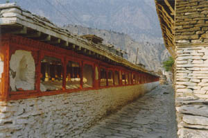
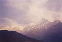
Jharkot - click to enlarge
Day 8 Jharkot

The landscape really changes today. We reach the so-called 'Tibetan plateau' a barren area of dusty hillsides. Villages and people get fewer. We are almost 4000m above sea level, and notice the change in altitude by our difficulty in breathing deeply. Our aim tomorrow will be Muktinath, an extremely holy place for both Hindus and Buddhists. Consequently, we are accompanied 
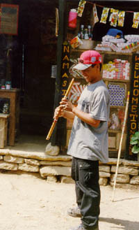
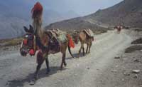
on the trail by many devout Hindus who have come on pilgrimage from all parts of India by horseback and foot. By late afternoon, it is getting 
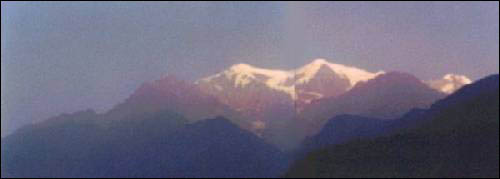
much cooler and ahead of us, settling over the 5000 m high Thorung-La 
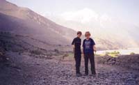
pass, a dark storm cloud is gathering. Sarah is not feeling well and so pushes on ahead to the next village and guesthouse.

Jharkot is a beautiful little village which, like Tukuche, has been a victim of depopulation. Whilst seeming almost deserted, it is full of character and very atmospheric. I spend a little while wandering around the maze of cobbled streets. As we arrive an archery contest is taking place between the men of the village. Chitra and I retire to the roof of the monastery to watch it while Sarah goes to rest. The windswept people look mostly Tibetan, as we are not far from the Chinese border.

This photo is of the Tibetan monastery in the middle of Jharkot village. As I look around inside, a black cat jumps onto the shrine and curls up on Buddha's lap. Returning to the guesthouse, the snow has started to fall up on the trail ahead. Even though it is almost spring, we are pretty high up. Sarah is feeling better and we talk to a cockney mother and daughter who have crossed over the notoriously difficult Thorung-La pass and are resting up to recover from moderate altitude problems. I also talk to a German archeologist who has been living here for some months to excavate some caves outside the village. I think we are the only tourists here. Very cold at night. Chitra outside Tibetan monastery, Jharkot
Chitra outside the monastery - click to enlarge

Day 9 Muktinath

There are natural water springs here as well as natural gas from the earth, the combined features of which make this a spiritual place for both Hindus and Buddhists. There is a Tibetan gompa (monastery) here as well as a Hindu shrine, dedicated to Jwala Mayi, the goddess of fire. We visit for the morning before deciding to push on to the village of Kagbeni on the banks of the Kali Gandaki. Dhaulagiri mountain (right) becomes visible above the clouds.
Dhaulagiri and the Kali Gandaki valley
Dhaulagiri - click to enlarge

kagbeni
The village of Kagbeni
Day 10 Kagbeni

We descend to the small village of Kagbeni, the most northernmost point that foreigners are permitted to the Tibetan border without paying huge amounts of money to take organised government tours to the restricted area. We stay only one night, and Chitra meets up with a rowdy bunch of his guide friends from Pokhara. The photo on the left is looking down the Kali Gandaki valley towards Jomsom. The next day, we start back to Jomsom where we have decided (wisely methinks) to fly back to Pokhara rather than walk the twelve days back.

Day 11 Jomsom

Smiles all round as we complete the last day of our trek. Early the next morning we head down to the aerodrome for our flight back to Pokhara on the world-reknowned Yeti airlines, with a fleet of one and space for all of six people. The flight is remarkalby smooth and we pass a huge glacier at eye-level as well as glimpsing parts of some of the other eastern peaks. On return, Pokhara seems like a bustling metropolis and we wish we were back among the mountains. However, there is still Kathmandu to explore.

Sarah and I on the trail back to Jomsom


Links
Muktinath official website: superb site of the Muktinath International Foundation covering all aspects of the holy area, Buddhism, trekking etc.
 
Šusethebuddha.productions2002
Hosted by www.Geocities.ws

1