After Canberra, the highway keeps its number - National 23 - but changes its name from the Federal Highway to the Monaro Highway. This is what annoys me most about Australians' attitudes to their roads; the numbering system is mostly logical, and most states sign their routes quite well, so why do Australians insist on referring to them exclusively by their (sometimes unofficial) names? Highway 23 is an important corridor linking Sydney to Canberra and then to Melbourne through Eastern Victoria, but it changes its name several times along the way and each section is referred to by its name. In Canberra itself, Highway 23 goes by several names. Northbourne Avenue, Commonwealth Avenue, Canberra Avenue, etc.
The Monaro Highway is named after the high, windy and mainly treeless plain to the south of Canberra called the Monaro. The highway through the Monaro is quite good, but rather unremarkable. There are several disused railway crossings where the now defunct Canberra-Bombala line used to run, and many overtaking lanes. Traffic was light on the night I travelled the highway, but on Friday nights in winter it gets quite choked as yuppie holiday makers from Sydney and Canberra head to the Snowy Mountains skifields to the west of Cooma.
I stopped for petrol in Cooma, which is the start of the multiplex of National 23 and National 18 (the Snowy Mountains Highway). The yuppies generally head west along National 18 up to the mountains, but I headed south along the multiplex. This multiplex is appallingly signed; sometimes signs indicate it as Highway 18; sometimes as Highway 23; sometimes both, and sometimes none. It's quite a schizophrenic road, though still of good quality, considering how lightly trafficked it was.
Several kilometres past the village of Nimmitabel, Highway 18 continues east to Bega but Highway 23 turns right to head towards the town of Bombala, which is where I spent the night. If I recall correctly, Highway 23 was not signed at this intersection, meaning those who were intending to follow National 23 all the way to Victoria would most likely get lost. But that's the RTA for you. The road deteriorated a little after Nimmitabel; surface reflectors disappeared; the shoulders became unpaved and sometimes non-existent; the curves became tighter and the linemarkings faded a little.
I stayed overnight in Bombala, and awoke the next morning to continue on my merry way. After Bombala, the road was much worse.
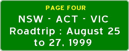
This is one of the better sections of National 23 to the south of Bombala. You can also see in the foreground a Victorian-style kilometre post which snuck in from over the border. However, this post measures the distance from Bombala, unlike posts in Victoria, which measure the distance from the General Post Office in Melbourne. New South Wales usually only marks distances every five kilometres using a green trapezoidal marker, shown here.
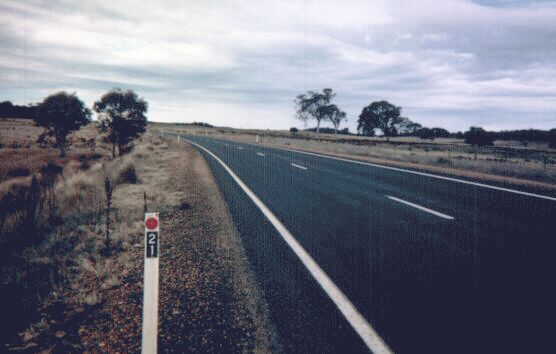
Before the NSW/VIC border, about six kilometres of the highway is still unsealed. This is a typical section of this gravel road. For a gravel road, it's quite well maintained; the earth is well compacted, the gravel is spread well, and there are few ruts or potholes. To its credit, the RTA is building a new alignment parallel to this stretch which will be fully sealed. It has taken them a while though, considering that Victoria completed the sealing of its stretch of National 23 in 1985!
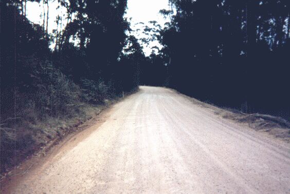
Now for a few snaps around the NSW/VIC border. This is the standard New South Wales welcome sign. Low-key, unpretentious, but welcoming all the same. The flower on the right is the state flower, the waratah. It's funny, I've lived in NSW for all of my 21 years but I have never seen a waratah in its native habitat. Strange.... but I digress. In the background, barely visible, are the standard road safety signs that inhabit the areas around state borders in Australia.
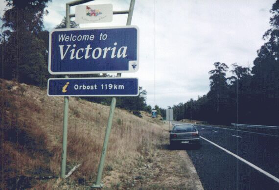
And this is on the other side of the road. A little more colourful and ornate, and the way it signs the distance to the next information centre is quite helpful. Up the top is a logo and the state's tourism slogan, "You'll love every piece of Victoria". Down the bottom right is the state's new logo.
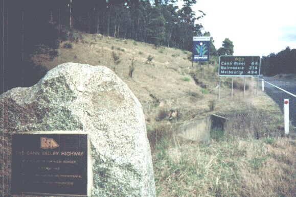
The stone monument in the foreground was placed there by the former Victorian Road Construction Authority to celebrate the completion of sealing of the Cann Valley Highway in 1985. The name of the highway changes from the Monaro Highway to the Cann Valley Highway at this point, by the way. The inscription reads in full: "The Cann Valley Highway was sealed to the NSW border in March 1985 as part of the Australian bicentennial road development programme". In the background, a standard Victorian distance sign can be seen - the route number changes slightly to B23 to accommodate Victoria's new numbering system. Further in the distance is a sign which says "Welcome to East Gippsland Shire Council".
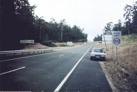
Whenever you cross a border in Australia, you'll see a sign which tells you what the state's speed limit on open roads is. Which is fine, except that this sign is in Victoria, and not New South Wales! Can't road maintenance crews see border signs or something? Victoria's speed limit sign is several hundred metres within the state behind the camera, if I recall correctly.
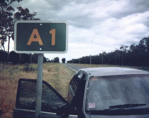
44km (27 miles) after the state border, the B23 ends at the village of Cann River at the A1 (Princes Highway). The A1 is part of National 1 which almost completely encircles Australia. For nearly its entire length from Sydney to Adelaide and through Victoria, it is known as the Princes Highway. I head west along this rather hilly but good quality road. The A1 bypasses the town of Orbost and onto the major town of Bairnsdale.
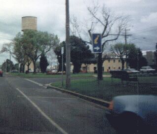
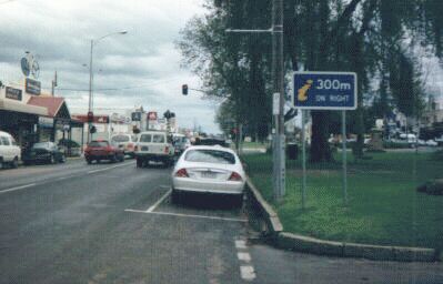
As you enter towns on main highways in Victoria, you will see many trailblazer and reassurance markers such as these in Bairnsdale pointing you to the local tourist information office. These are extremely helpful and innovative for tourists, and the signage is much more frequent than you might see in towns in New South Wales. I can't help but get the feeling that the NSW RTA has a *LOT* to learn from its Victorian counterpart, VicRoads.
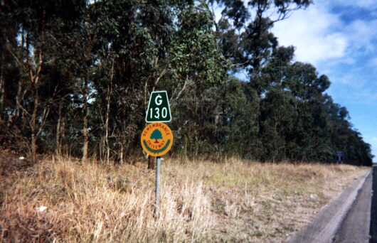
This is a typical route marker on Victorian, Tasmanian and South Australian roads. These three states now use the British system of numbering roads. The letter prefix indicates the grade of road. In Victoria, there are four grades of road - 'M' for motorway, and 'A', 'B' and 'C' for other roads in descending order. National Routes have lost their shields but still keep their numbers, but National Highways still have the National Highway shields with the new prefixed numbers inside the shield. These markers don't appear very often, as directional signage is of an excellent standard and distance signs with the route numbers on them are very frequent.
I then continued westward along the A1 to Melbourne. I passed through the area of Victoria known as Gippsland, which basically covers everything east of Melbourne and south of the Great Dividing Range. At Traralgon, the A1 upgrades itself to the M1, but much of it isn't full freeway standard. There are still many grade crossings across the divided carriageway and some towns aren't bypassed. I can't wait until they are bypassed though, the towns in this part of Gippsland are characterless, heavily industrialised and so uniform in nature that I forget what most of them look like. All I remember is that I stopped to get some KFC in Sale, or was that Morwell, or perhaps Traralgon? I forget.
The M1 joins up with the South-Eastern Freeway in the Melbourne suburb of Doveton, but I stayed on the Princes Highway, which is signed as Alt-1. I stayed overnight in a motel in the suburb of Oakleigh.
© Bradley Torr. Last updated 22-Jan-2003.