Tourist Hot Spots in
Democratic People's Republic of Korea
|
|
|
|
|
Tourist Hot Spots in Democratic People's Republic of Korea |
�@
|
Pyongyang ���[��
It is the center of whole Korean politics, spirit, economics, culture, and
tourism. Occupying an area of 2600km2, it has a population of
3,430,000. Pyongyang was once the capital of Koguryo (37-668 B.C.),
founded by Jumong and Koguryo, the very first nation of the Korean
peninsula. The whole ancient city was destroyed by US imperialist during
Korea war. Famous
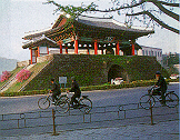
tourist sites include the Taedong Gate, Potong Gate, and Tomb of King
Tongmyong. Taedong
Gate
is the east gate of Koguryo Pyongyang walls�� inner complex. The most
important of all Pyongyang wall gates, it is Korean national treasure no.
1. Potong
Gate
is also a relic from the Koguryo era, and is Korean national treasure no.
2. The
Tomb of King Tongmyong
is the gravesite of King Tongmyong, founder of Koguryo, it was discovered
and excavated in 1974. It
is known for the murals of lotus blossoms that graces its walls and
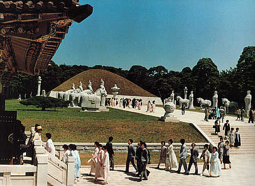
ceilings. Dangunneung
is a pyramidal grave of nine sections built out of
granite. Moran
Hill is
named after the Moran flower; it has four castles called Namsong, Oesong,
Chilsong Gate and Ulmil
Pavilion. Ulmil
Pavilion
was built in the middle of the 6th century, but was rebuilt in 1714.
��Ulmil Pavilion��s spring�� is one of 8 scenic spots in
Pyongyang. Other places of
interests include the Korean Revolutionary Museum, Victorious Fatherland
Liberation War Museum, Korean Art Gallery, Potonggang Park, Central
Botanical Garden and Central Zoo. ���O���@�ɴ��A���ڪ��믫�B�F�v�B�g�١B��ƩM�ȹC���ߡC���n2,600km2�A�H�f343�U�C���O���A�b�q�̦�����a�j���A�M�Ѧ��X�إߪ����y�R(B.C. 37-668�~)�������A��ӥj���b���A�Ԫ��ɶ��Q�J�I�����Ұ�D�q�̲������a�C �j�P���B���q���B�F�������B�ȧg���B�d���p�B�A�K�O�����O���W���[�����I�C�䤤�A�j�P���O���y�R�ɴ����[���������F���A�O���[�Ҧ��������̭��n�������A�]���Q���w爲���A���D�D�q�H���@�M�ꪺ��1�����_�C ���q���]�O���y�R�ɴ��������A�{�Q���w爲���A���D�D�q�H���@�M�ꪺ��2�����_�C �F�������h�O���y�R���}��ӫҪF�������X�өҦb�a�A1974�~�X�g�A�H�|�P��W������ϮצӻD�W�C �ȧg���Ѫ��r��Ҽ˪�9�y�զ��^���զ��C �d���p���A�K�O�W�A�P���٦����j�R�ɴ������B�~����}�M�C�P�������I�C �A�K�O���O6�@���������y�R�������_�N�O�A�ة�1714�~�C�{�b�A���A�K�O��K�� �O���[�K�����@�C ���~�٦����A���R�ժ��]�B����ѩ�Ԫ��ӧQ�����]�B���A���N�ժ��]�B���q���C��a�B�����Ӫ���B�����ʪ��鵥�C �@ Mountain
Guweolsan-Orchard
�E��s-�G���
Mountain Guweolsan is 954m tall and contains the famous Yongyeon Falls,
Guweolsansanseong Fortress site, and kiln site. Yongyeon Falls is where
all the rivers of the mountain converge to crash over a fall- a fantastic
sight. The site of the Guweolsansanseong Fortress site manages to give an
idea of the vastness of the fortress when it still stood- its
circumference was 5.23km long. The kiln site was used to fire Koryo
celadon. Mt. Guweolsan was also the place where Korean People��s Amy
fought against the US imperialist and its puppet army during the 6-25 War.
Gwail-gun is comprised of over 70% fruit fields and orchids--the largest
fruit-producing region in Korea. Because it is in close vicinity to
Pyongyang, it is perfect to visit together. |
||
|
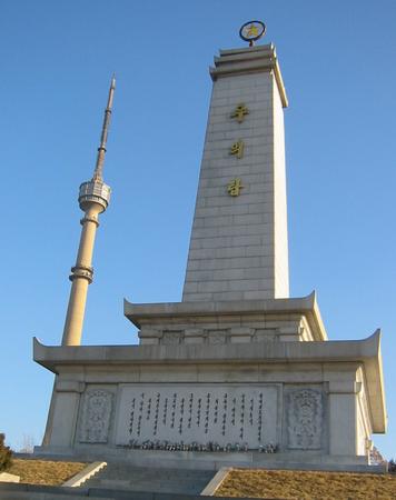
Sino-Korean Friendship Tower erected in 1st October, 1959. |
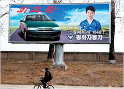
Advertisement Board Korean Vehicle in 2004 |
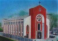
Changchun Cathedral build in 1988 |
|
|
|
|
|
���¤ͽ˶� 1959�~10�~1��إ� |
���[�겣�⨮�ӫ~�s�i�P(2004�~) |
���[�C�K�ѥD�а�(1988�~) |
|
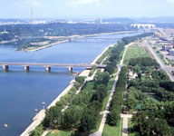
Taedonggang river, one of the 5 long rivers, 450.3km |
Moran hill, one of the 8 scenic spots. 96m high |
Mountain Taesong, former royal palace of Koguryo, it has Zoo and botanical garden. |
 |
 |
 |
| �j�P���O���A�������j�e���@�A450.3km |
�d���p�A�K�j���I���@�A��96m |
�j���s�A���y�R�Ӵª��Ӯc��}�A �{���ʴӪ�����C |
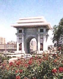
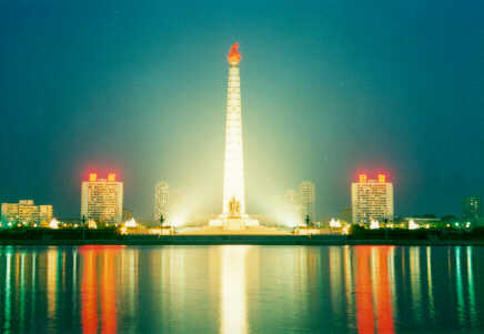
| Tower of Juche Idea, 170m | Arch of Triump, 60m | Grand Mounment, Mansu hill |
 |
 |
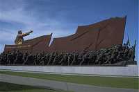 |
| �D���Q��A170m | �ͱ۪��A60m | �U�ؤs�����O |
|
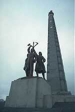
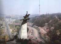
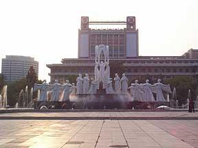
Chollima Status Erected in April, 1961, 46m height, 100 tons weight. |
Tomb of King Tongmyong |
Taedong Gate Korean national treasure no. 1 |
 |
 |
 |
|
�d�����ɹ� 1961�~4��سy�A46m���A ���q��100 tons�C |
�F������ |
�j�P�� ���A��1�����_ |
| People's Study House | Kim Ii Shing Square | Mansudae Art Theatre |
 |
 |
 |
| �H���j�Dz߰� | ���馨�s�� | �U�ػO���N�@�| |
|
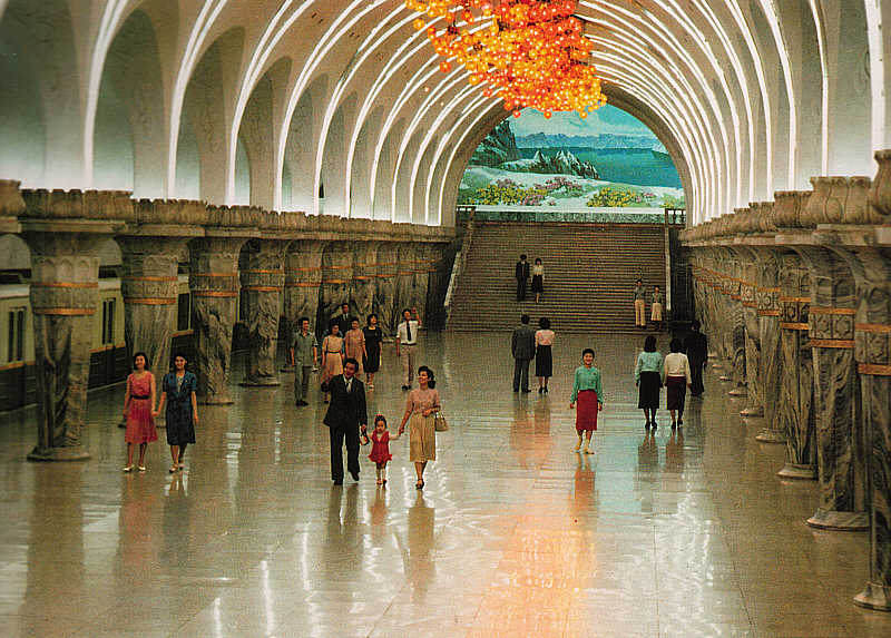
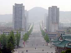
Metro - Yonggwang Station |
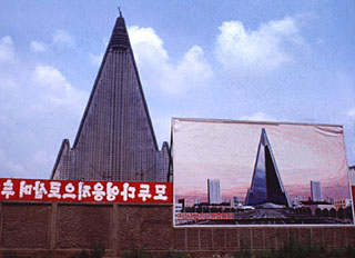
World's tallest Ryugyong Hotel (105 stories) in progress |
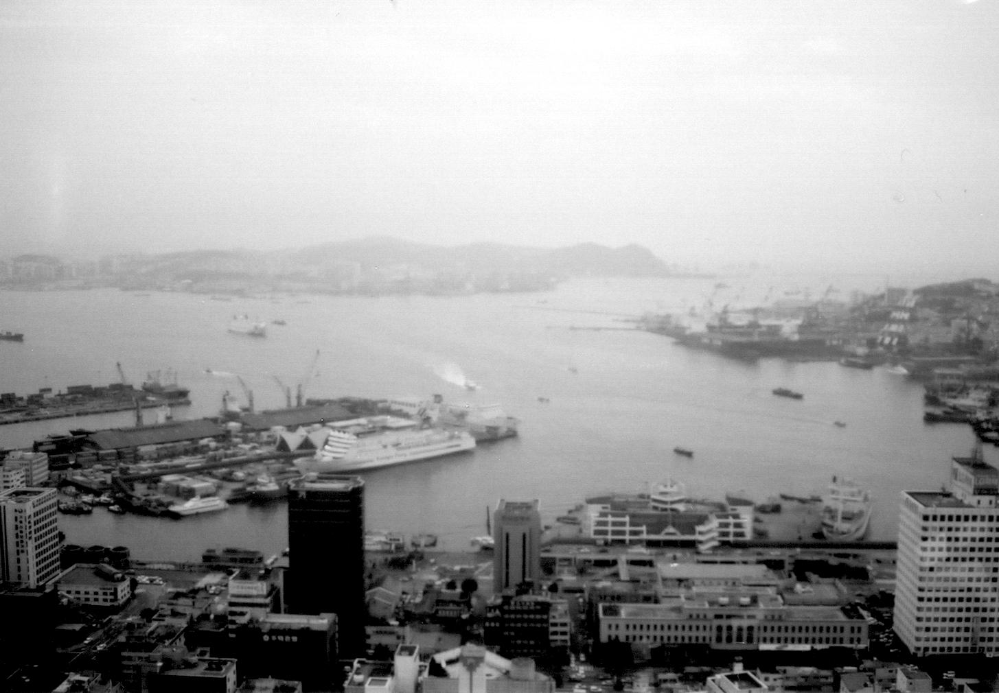
Pyongyang at night |
 |
 |
 |
| �a�U�K���a������ | �b�ؿv�����@�ɳ̰���105�h�h�ʶ��� | ���[���] |
|
Kaesong,
Nampo
and Mountain
Myohyang,
South
Phyongan Province ���w�n�D - �}�����A�n���� �M �����s Kaesong
�}��
Kaesong was the capital of the Koryo dynasty (918-1392) for about 500
years. It occupies 1200km2 and has a population of 390,000.
Beginning in the Koryo era. It cultivated a history of fine craftsmanship
(the Koryo celadon is an example) and international trade. Kaesong was
also active in ginseng production, and the Koryo ginseng from the area is
world famous. Tourist sites include the Sonjuk Bridge and Nam
Gate. The Sonjuk
Bridge is a Koryo era (1392-1910) stone
bridge, and in the east there is a memorial containing the calligraphy of
the Chosen era��s famed calligrapher Han Sok
bong. The Kaesong
Nam Gate is the south gate of the Kaesong
fortress. Pagyon
Fall has two small ponds, Pagyon pond is the
upper one and Komo pond is the lower one. Thanks to the gazebo next to the
Fall, one can relax while enjoying the view. Tomb
of King Kongmin is a twin tomb for king and
queen. In the tombs are a 12 animal mural (Jisinsang) drawn by king
Tongmin. Other attractions include the Kaesong
History Museum. �@ Nampo�n����
Nampo is an
international port city with an area of 82.9km2, it has a
population of 800,000. There were about 10 islands in the area until the
1960��s, but beginning in the 1970��s the islands became connected
through artificial land and roads by development. Nearby tourist sites
include the Taeseongho Lake and Ssangyeongchong.
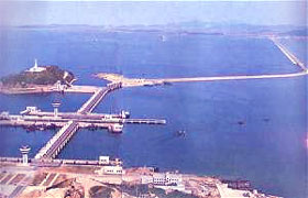
West
Sea Barrage is a gate (35m high, 8km in length) in the mouth of the
Taedong River so ships up to 5
tons can pass by. The beautiful Taesong
Lake is a multi-purpose dam with an area of 7.79 square
kilometers and a circumference of
32.5km. The Sangyongchong
is a Koguryo era grave with murals of people and the 4
gods painted on its walls. �@ Mountain
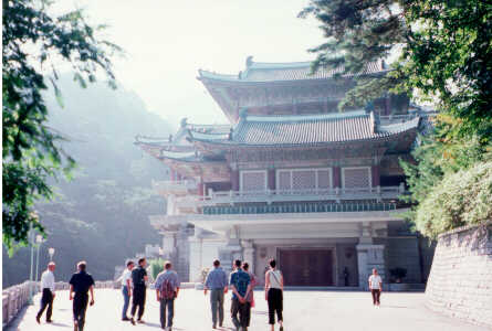
Myohyang �����s
Mountain Myohyang is 1,909m tall, and is named Mountain Myohyang because
of its strange and beautiful shape. The temperature average is 8.3 degree
Celsius. There are a wide variety of plants as well as rare animals.
Historically the mountain is significant because in 1592 (25th year of
King Sonjo��s rule, Choson era), when faced with the Japanese invading
forces, the monk Hyu Jong gathered a militia of monks in the mountain in
defense for fatherland. Making it even more attractive as a tourist spot
is the Tangun Temple, which contains relics of Tangun, founder of
Gojeoseon- the very first nation on the Korean peninsula. Also in the area
is the International Friendship Exhibition, which exhibits various gifts
given to Korean from nations around the world. The Myohyangsan History
Museum and Mountain Myohyang spring water are also worth noting. |
||
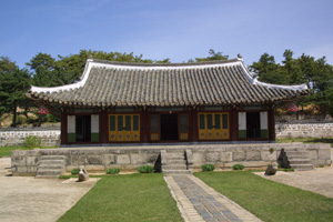
| Nam Gate | Songgyun Academy | Tomb of King Kongmin |
 |
 |
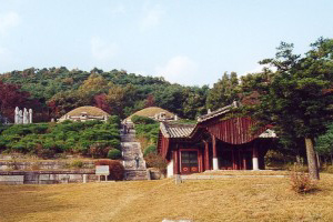 |
| �}���n�j�� | �}�������] | �������� |
| International Friendship Exhibition | Mountain Myohyang | Kaesong city |
 |
 |
 |
| ��ڤͽˮi���] | �����s | �}���� |
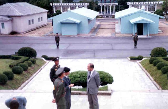
| Panmunjom | West Sea Barrage | Nampo Harbour |
 |
 |
 |
|
�O���� |
������h |
�n����f |
|
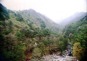
Wonsan and Mountain Kumgang, Kangwon Province ����D
- ���s��
�M ����s Encompassing
the 110km area from Wonsan (a port city) to Mountain Kumgang, this area is a tourist heaven
which contains fabulous shores, lakes, mountains, and temples. Mountain Kumgang is home to the Piro
Peak, the tallest point of the
mountain and 1,638m. With 12,000 mountain peaks, valleys, waterfalls, and
ponds, it is a truly phenomenal vision of nature. There are over 940 types
of plants as well as endangered fish species. Major tourist sites of the
area include the Kuryong Falls, Manmulsang, Lagoon Samil, and Sea Kumgang.
The Kuryong Falls are the greatest in Mountain
Kumgang, the Manmulsang is a collection
of oddly shaped boulders, and the Lagoon Samil and Sea Kumgang are places
that offer the beauty of lakes and oceans.
Wonsan is a port city situated
on the east coast, with a population of 280,000. ��f�������s�ܪ���s110km���϶������Ѯ����B����B�s�Φh���[�����I�զ��C����s�@��1�U2�d�y�s�p�A�䤤�D�p�s�c�p��1,638m�C���~�A�˽\�B�r���B�������H�B�i���A�s�W�٦�940�h�شӪ��μ��س����ñ��O�@�����C����s�ۦW�����I���E�s�r���B�U���ۡB�T����M������C �E�s�r���O����s�̤j���r���A�U���������F�U�اκA�����ۡA�T����M�������h���O�H����M���䪺����ӥX衆�C ���s�����ªF���A�H�f28�U�C |
||
| Port of Wonsan | Lagoon Samil | Mountain Kumggang |
 |
 |
 |
| ���s�� | �T��� | ����s |
|
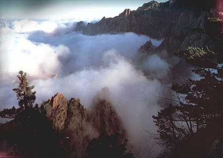
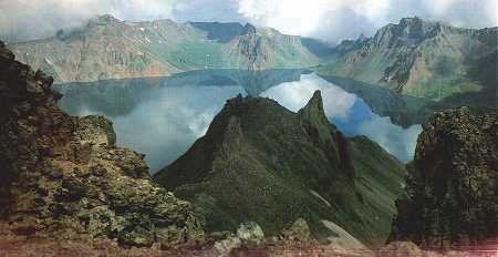
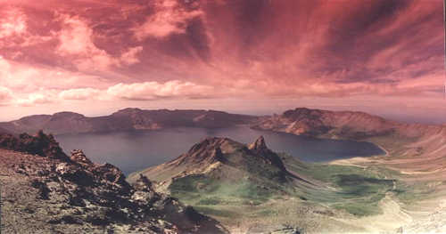
Mountain Paekdu, Ryanggang Province �⦿�D - ���Y�s(���դs)
Just at the Sino-Korean boundary, with
a peak at 2,744m, Mountain Paekdu is the highest mountain in the Korean
peninsula. A dormant volcano, its volcanic activity began dying down about
2 million years ago, forming its current shape. Its climate is typical of
high altitudes, with extreme temperature fluctuations. The average
temperature is 6 to 8 degree Celsius, with an average rainfall of 1,500mm.
Many rare animals inhabit the area, including tigers, bears, and
panthers--as do over 2,700 plant varieties. At the peak of the mountain is
the Lake Chon, a caldera lake with an area of 9.17 km2 and an
average depth of 213.3m. It is surrounded by peaks, and harbors many
marine life forms. ���¨�ꪺ��ɰϡA����2,744m�����Y�s�O���A�b�q�W�̰����s�C��200�U�~�e�A���Y�s�����s�B�ʳv����֡A��爲�@�y��v���s�çΦ��F�{�b���s��C���Y�s�����爲�嫬�����s��ԡA�ܤƫܤj�C�~�������6-8�J, �~���������q爲1,500mm�C���Y�s�W���Ȧ������\�B�Ѫ�B�����õ}�ʪ��A�٤��G��2,700�h�شӪ��C���Y�s���W�����s��Ѧ���������213.3m�A ���n9.17km2�A�����b�|�P�s�p���h���ءC�Ѧ��ئs���ۦU�ؤ����C |
||
| Lake Chon | Lake Samji | Sun Raising in the East |
 |
 |
 |
| �Ѧ� | �T���W | �F����A�Ӷ��@ |
|
Sinuiju
and Uiju, North
Phyongan
Province
�w���_�D
-
�s�q�{�A�q�{�a��
Sinuiju is a transportation hub located at the mouth of the River Amnok.
Sinuiju city is laid out in the form of a checkerboard, with the northeast
region occupied by government agencies and residences, and the industrial
area on the River Amnok. With an area of 10.6km2 and a
population of 32,500, Uiju is a major
city as Pyongyang or Kaesong, filled with historical artifacts that
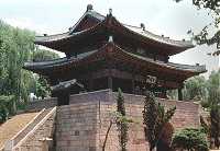
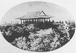
include Thonggun Pavilion. The Thonggun
Pavilion is a raised gazebo, which served as
a military lookout during the Koryo era. Its festive structural design is
notable. |
||
|
River Amnok |
Sinuiju SAR Emblem |
Thonggun Pavilion |
 |
 |
 |
| ��������n�� | �s�q�{�S�O��F�ϰ��� | �έx�F |