![]()
Spanish
Colonization
American Period
Japanese Occupation
Timeline
Officials
![]()
Geography &
Climate
Map & Places
The People & Celebrations
Commerce & Industry
Economic Growth
Transportation &
Communication
Support Facilities
Health Services
Sports & Recreation
Schools & Universities
Government Officials
Cable Channel
Radio Station
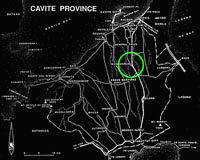
Geographic Location
Dasmariñas is about 8,234 hectares, 12 kilometers from Metro Manila or the the National Capital Region and 27 kilometers south of the center of the City of Manila. It is bounded by the municipalities of Imus and Silang, both in Cavite at the north and south respectively, at the east by the towns of San Pedro and Biñan by the side of Laguna Province and Carmona and at the west, it is bounded by General Trias,also in Cavite and a little further from this boundary is Trece Martirez City.
It is strategically located at the Intermediate Zone of the Metropolitan Manila Area. With adequate accessibility, Dasmariñas is within the urbanizing development influence of Metro Manila area.
It is composed of the Poblacion and the barangays. The Poblacion which is now divided into four zones is on the westernmost section of the municipality, Sabang and Salitran and at the south are San Agustin, Langkaan and Sampaloc. On the east are Burol, Salawag and Paliparan.
The town of Dasmariñas is landlocked. However, it is not too far from the coastal towns of Rosario, Kawit, Bacoor, Noveleta and Cavite City whose average distance from Poblacion is less than 30 kilometers. It is about the same distance from Laguna de Bay and about 27 kilometers from the resort city of Tagaytay and the famous Taal Lake.
At present, Dasmariñas is served by corridors traversing the central areas which provide linkages to the Metropolitan Manila area core in the north and the developing nodes of Laguna and Batangas.
Topography
Dasmariñas is partly lowland and partly hill. The Poblacion itself is elevated. From an elevation of 80 meters at the Poblacion, the land rises to 250 meters towards Silang. Generally, land near rivers and creeks are rugged. Dasmariñas is outside the typhoon belt and has no fault line constraints. Further, it is served by natural drainage system since it is traversed by several rivers and water tributaries draining to the Manila Bay. The town has not yet to experienced floods.
Slope
Strongly sloping to elevated areas cover approximately 1,532.16 hectares or 18.61% of the total area. These are dispersed among Burol, Langkaan, Paliparan, Salawag, Sampaloc and San Agustin. Areas with slopes 10.1 to 18% cover about 575.72 hectares of land in portions of Salawag, Salitran, Burol, and other parts.
On the other hand, gently sloping or under lating areas comprise merely 710.4 hectares or 8.62% of the total land area while under lating areas with slope of 2.6 to 5% account for the biggest percentage of 50.59% of the total land area equivalent to 4, 165.64 hectares of land which are dispersed over the municipality except Sabang and San Jose.
Climate
Two pronounced seasons: wet season and dry season. Wet season covers the period from May to December of each year and dry season covers the period from January to April.
The temperature in Dasmariñas has been noted to range from below 60 F to about 90 F. Further, south, however, where there is a higher elevation, the temperature becomes as cool as 50 F during the Christmas season.
Best viewed with Microsoft Internet Explorer 5 and up at 800x600 resolution
Copyright © 2003, DASMA ONLINE. All rights reserved.