A
FEW FACTS ABOUT ILHA GRANDE & ANGRA DOS REIS... A
FEW FACTS ABOUT ILHA GRANDE & ANGRA DOS REIS...
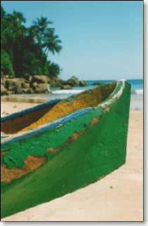 Angra dos Reis is
surely one of the most
beautiful places in Brazil. It is said to have 365 islands (one for
each day of the year) and 2000 beaches, though this may rather sound
like some sort of marketing department's slogan. Angra is often associated with rock stars, movie stars, models, and
other jet-set people that visit this exotic piece of tropical paradise. Angra dos Reis is
surely one of the most
beautiful places in Brazil. It is said to have 365 islands (one for
each day of the year) and 2000 beaches, though this may rather sound
like some sort of marketing department's slogan. Angra is often associated with rock stars, movie stars, models, and
other jet-set people that visit this exotic piece of tropical paradise.
The favourite attraction is "Ilha Grande", that, albeit the
name ("Big Island"), is not Brazil's largest island (the
title goes to Ilhabela). Literally untouched after many decades of
isolation, due to the existence of a - now demolished - high security
state prison, most of this former pirate hideout is now
environmentally preserved as a State Park.
Without roads, this
193 km2 mountainous
island, surrounded by 106 beaches and offering its visitors incredible waterfalls, is
the
perfect hiking spot. Along the colorful and
densely subtropical vegetation covered coast, one will find endless hiking
trails, with breathtaking waterfalls along the way.
A complete
Ilha Grande experience requires the freedom and mobility of a yacht.
Secluded, clean, and unpolluted white-sands beaches, offer sceneries
that equal or surpass those of nowadays so crowded Caribbean. And
above all that, you'll have world famous Brazilian hospitality !
On
the continent, BR-101 Rio-Santos highway winds along the coast, but it
is hard to keep an eye on the road due to the astounding scenery. Located ca. 100 miles
from Rio de Janeiro, Angra dos Reis covers an area of 316 sq. miles
and has 4 districts: Angra, Cunhambebe, Ilha Grande and
Mambucaba.
THE
DISCOVERY... It
was a Portuguese tradition to name newly found land for the day of the
discovery. Rio de Janeiro is the typical example: that bay, at first
thought to be a large river ("rio") mouth, was discovered on
1st January ("janeiro"), 1502. Five days later,
that very same expedition, headed by Portuguese navigator André
Gonçalves, made the same confusion again... Sailing
through the channel between the mainland and Ilha Grande, the
expedition did not realize, at that point, that Ilha Grande was in
fact an island, thus never naming it. Considering Ilha Grande to be part of the mainland, the expedition thought to have already reached the end of the
bay ("angra"). Near the site where Angra dos Reis
city was later built, they finally realized they've made a mistake, and as it
was the Catholic Church's "Santos Reis Magos"
commemoration day, the place was baptized Angra dos Reis. The
city was only founded 106 years later (in 1608). By
that time, the only inhabitants were indians, that were gradually
enslaved by the Portuguese settlers, as they founded villages where
today is Mangaratiba, Mambucaba
and Paraty.
500
YEARS AGO... Many
were the expeditions and adventures along the Brazilian coastline
after the discovery, most of them recorded in historic documents and
manuscripts. Some of these state that, by 1552, Ilha Grande was part
of the Tamoios indian nation, whose limits extended from Cabo Frio
(northern Rio de Janeiro state shore) to Ubatuba (northeastern São
Paulo state shore), there bordering the Guaianás-Guaranis indians'
lands. Ipaum
Guaçu was the name given by the Tamoios indians, and in tupi language
"Ipaum" means "Ilha" (island) and
"Guaçu" means "Grande" (big). German adventurer
Hans Staden was the first European to record this information,
publishing it in his 1557 works. Padre Anchieta, the famous Brazilian
indians' cathechesist, did also register the Tamoios indians presence
on the island. According to him, they lived in small, 150-inhabitant
villages, and were fearless warriors, hunters and fishermen. Apart
from their different language, they also had different customs. The
vegetation, similar to that on the Serra do Mar range, was only
preserved on the mountains. The following centuries saw major
deforestation along Ilha Grande's shoreline, and early records
describe Ilha Grande's forests as the most beautiful ones along
Brazil's coast: enormous trees, orange- and lemon-trees were part of
the natural flora. The forest, by that time, was much denser, making
hunting a very difficult activity. Fauna included - and still includes
- monkeys (many can still be easily found today), alligators (none to
be found today, although a single specimen was brought to the swamps
behind Lopes Mendes beach !), lizzards, snakes, rodents, etc.
PIRACY,
TRAFFIC AND SMUGGLING... Between
the 16th and 19th centuries, Ilha Grande played
a key role in international piracy, slave traffic, and smuggling
episodes. When
gold and silver were discovered in Peru in late 16th
century, the Rio de la Plata basin became known for the wealthy cargo
shipments to Spain. Strategic water and food resupply ports along the
way to Europe were the Brazilian islands of Santa Catarina, São
Sebastião (Ilhabela) and Ilha Grande. At the same time, Portugal came
under Spanish rule, lost its "invincible armada" and left
the Brazilian coast unprotected. The much sought-after pau-brasil
tree became a major contraband item. Pirates
and adventurers from all over the world sailed along the Brazilian
coast, targetting gold and silver loaded Spanish galleons. The
Brazilian coast offered many hideouts and resupply ports, and Ilha
Grande was a favourite. There, pirates and contrabandists had both
their safe anchorages and their needed rest's tranquility. Potable
water, wood, and food was abundant, and the Portuguese seemed not to
object to their presence. 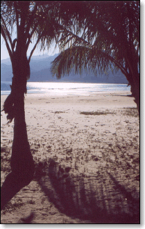 With
the discovery of the Brazilian mines, in Minas Gerais, African slaves
were in need, and Ilha Grande was the strategic place for such
contraband. And so it continued to be, especially in the 19th
century, when, albeit traffic prohibition, slaves for the coffee
plantations continued to be sold. Slaves contrabanded in Ilha Grande
were to be found along the horseback routes to Minas Gerais (the
"Golden Route", starting in Paraty), and the trails to Rio
de Janeiro and São Paulo. With
the discovery of the Brazilian mines, in Minas Gerais, African slaves
were in need, and Ilha Grande was the strategic place for such
contraband. And so it continued to be, especially in the 19th
century, when, albeit traffic prohibition, slaves for the coffee
plantations continued to be sold. Slaves contrabanded in Ilha Grande
were to be found along the horseback routes to Minas Gerais (the
"Golden Route", starting in Paraty), and the trails to Rio
de Janeiro and São Paulo.
History
records a large number of English corsairs sailed along the Brazilian
coast, either trafficking slaves, contrabanding pau-brasil,
or attacking ships and local cities. From 1585 to 1605, their
preferred hideouts were the islands of Marambaia, Porcos, Grande, São
Sebastião, and Santa Catarina, in the vincinity of which gold and
silver loaded Spanish galleons had to sail. Galleons
from the Netherlands were also to be found at Ilha Grande in the
beginning of the 17th century, with some recorded conflicts
with the indian-portuguese inhabitants. Their European genetic
heritage throughout Ilha Grande can still be observed in some of
nowadays few blond, blue-eyed caiçaras and indian descendants. A
few years later, between 1701 and 1718, Ilha Grande was under French
influence. The French corsairs had special interest in Ilha Grande, as
it was in the vincinity of Paraty, where gold from Minas Gerais was
shipped to Portugal. Troops and fortifications were inexistent,
potable water and wood was abundant, and, above all, Ilha Grande's
geography offered many safe fleeing routes. There are many records of
French ships unloading contrabanded goods in Ilha Grande, most
precisely at Palmas, Abraão, and Sítio Forte bays. When
international treaties extinguished French piracy, the French started
sailing legally along the Brazilian coast, and continued to prefer
Ilha Grande. The reason was clear: higher costs existed if cargo ships
resupplied in Rio de Janeiro; anchoring at Ilha Grande, and taking for
free whatever was needed, would always be easier ! In
1827, authorized by the Argentinian government, corsairs attacked Ilha
Grande three times. One attack was against the Dois Rios plantation,
another at Castelhanos point, an the third, at Palmas Bay. All of them
were defeated by the farmers and Brazilian military forces stationed
in the island. In the last battle, an Argentinian ship was set on fire
by the Brazilian forces.
SLAVE
TRAFFIC... The
traffic of African slaves started between 1510 and 1540, a few years
after Discovery. Pirates and corsairs from France, England, and the
Netherlands used the bay of Ilha Grande to contraband slaves.
Traffickers stayed for very short periods: once the slaves were
disembarked, they were taken clandestinely to the vincinity of Paraty.
Palmas and Abraão bays were routinely used for this purpose in the 18th
century. Records
show that in 1837, a total of 524 African slaves disembarked at Dois
Rios beach, where a big plantation existed. Other records state that
two ships were set on fire in front of the plantation, and that their
slave cargo was hidden for many days at Toca das Cinzas cavern. In
the first half of the 19th century, England, focused on
industrialization, put pressure on Portugal to prohibit the slave
traffic. In theory, Portugal intensified coastal patrols, but in
truth, Portuguese authorities were economically interested in such
traffic. It was not until 1850 that Portugal effectively started
patrolling Lopes Mendes, Abraão, Palmas and Estrelas bays - in this
last one there was even an advanced Navy station.
COLONIZATION
STARTS... 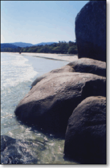 Although
colonization started between 1725 and 1764, the first records on Ilha
Grande's early settlement attempts date back to 1591. English sailor
Antony Knivet, crewmember of a pirate fleet, wrote that as they
anchored at Ilha Grande, 5 or 6 houses were found, inhabited by
portuguese-indians that planted manioc, sweet potatoes, and bananas;
pigs and chicken were also found. They looted and set that settlement
on fire, before leaving to intercept Spanish galleons coming from the
Plata basin. Although
colonization started between 1725 and 1764, the first records on Ilha
Grande's early settlement attempts date back to 1591. English sailor
Antony Knivet, crewmember of a pirate fleet, wrote that as they
anchored at Ilha Grande, 5 or 6 houses were found, inhabited by
portuguese-indians that planted manioc, sweet potatoes, and bananas;
pigs and chicken were also found. They looted and set that settlement
on fire, before leaving to intercept Spanish galleons coming from the
Plata basin.
European
publications dated from 1764, describe two houses: one, owned by
Spanish pirate Juan Lourenzo at Praia do Morcego (Abraão bay) and
another at Enseada das Estrelas. To this day, old powder cannons can
still be seen along that shore, near the beach. Cartographic
surveys were held in 1809 from Castelhanos Point to Enseada das
Estrelas. The resulting charts indicated 14 houses distributed along
Praia Grande das Palmas, Praia dos Mangues (7 houses), Praia Grande do
Pouso, and a single house at Praia das Aroeiras. From these 14
buildings, 2 were much bigger: one located at Praia Grande das Palmas,
and the other at Praia do Pouso. 12
houses were indicated at Enseada do Abraão, a group of them forming a
large sugar plant near the beach nowadays known as Praia da Júlia,
two at Praia Preta, the plantation house of "Fazenda do
Holandês" ("The Dutch's Farm"), the slaves' housing, two others in front of Ilhas do
Macedo (Abraão bay), and one at Praia do Morcego. Noteworthy is the
fact that the "Fazenda do Holandês" originally belonged to
Dutch seamen came with the Dutch galleons. Enseada
das Estrelas had the majority of the houses according to the 1809
survey: 24 buildings, from houses to sugar plants were scattered
between Praia da Feiticeira (where a plantation with the same name
existed), Praia de Iguaçú, Praia de Camiranga, Praia Grande, Praia
de Fora and Perequê, where a former plantation house can still be
seen today.
SUGAR
CANE PLANTATIONS & SLAVERY... 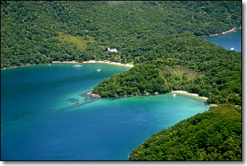 Ilha
Grande had, in the 19th century, a total of 9 sugar cane
plantations, producing alcohol and sugar. They were located at Enseada
das Estrelas, Freguesia de Sant'Ana, Matariz, Sítio Forte, Praia da
Longa, Praia de Dois Rios, Enseada das Palmas, and Abraão. Ilha
Grande had, in the 19th century, a total of 9 sugar cane
plantations, producing alcohol and sugar. They were located at Enseada
das Estrelas, Freguesia de Sant'Ana, Matariz, Sítio Forte, Praia da
Longa, Praia de Dois Rios, Enseada das Palmas, and Abraão.
Apart
from sugar cane, coffee was also planted, although only Mambucaba and
Ilha Grande produced coffee. All other Angra dos Reis nearby villages
continued to produce sugar, that was also exported to Europe. Historians
that visited Ilha Grande at that time pointed that the Dois Rios farm
was a beautiful and well organized property, with 200 slaves working
in the coffee plantation. The slaves' housing ("senzalas")
was built with unusual quality, and although there was no pier, the
farm's location offered natural disembarkment conditions. During
the 18th and 19th centuries, a large portion of
the native rain forest gave place to sugar cane, and later, coffee
plantations. The second half of the 19th century saw the
end of slavery and the decline of the coffee business, bringing with
it regional economic decadency.
EMPEROR D. PEDRO II AND THE LAZARET... 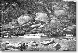 By
mid 19th century Brazil lived under the rule of Emperor Dom
Pedro II. It was by then that the construction of a new Lazaret (a sort of quarentine hospital for immigrants)
became necessary. Its location should be adequate to receive the many
immigrants that contracted cholera during their voyage across the
Atlantic. Studies were already being conducted when the Emperor visited
Angra dos Reis for the first time in December, 5th, 1863.
In his personal diary, preserved at the Imperial Museum in
Petrópolis/RJ, he registered in text and drawings this visit to Ilha
Grande, never hiding his enchantment for the island's natural beauty.
It is possible that his personal will prevailed when, later, the
Lazaret's location was chosen. By
mid 19th century Brazil lived under the rule of Emperor Dom
Pedro II. It was by then that the construction of a new Lazaret (a sort of quarentine hospital for immigrants)
became necessary. Its location should be adequate to receive the many
immigrants that contracted cholera during their voyage across the
Atlantic. Studies were already being conducted when the Emperor visited
Angra dos Reis for the first time in December, 5th, 1863.
In his personal diary, preserved at the Imperial Museum in
Petrópolis/RJ, he registered in text and drawings this visit to Ilha
Grande, never hiding his enchantment for the island's natural beauty.
It is possible that his personal will prevailed when, later, the
Lazaret's location was chosen.
The
Emperor first visited Enseada das Palmas, and then his fleet headed to
Abraão, where he spent the night at the "Fazenda do
Holandês" plantation. During his stay at Abraão village, he
gave money for the local church's construction (the one that still
exists at the central saquare, in Abraão). 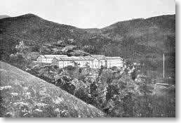 In
1884, the Empire first acquired the "Fazenda do Holandês"
property, and then, the "Dois Rios" plantation.
"Fazenda do Holandês" began at Praia Preta and ended near
where today is the Abraão pier. On the other side of Ilha Grande, the Dois Rios plantation
belonged to the Guimarães family, and the property's area originally
started near Lopes Mendes beach (specifically at Santo
Antônio beach), and extended to a place called " Mar Virado", near
Parnaioca beach. Later, an additional area at a location called "Bica",
near Ponta Grossa, was also acquired. All these areas still belong
to Brazil's Federal Government. In
1884, the Empire first acquired the "Fazenda do Holandês"
property, and then, the "Dois Rios" plantation.
"Fazenda do Holandês" began at Praia Preta and ended near
where today is the Abraão pier. On the other side of Ilha Grande, the Dois Rios plantation
belonged to the Guimarães family, and the property's area originally
started near Lopes Mendes beach (specifically at Santo
Antônio beach), and extended to a place called " Mar Virado", near
Parnaioca beach. Later, an additional area at a location called "Bica",
near Ponta Grossa, was also acquired. All these areas still belong
to Brazil's Federal Government.
The
Lazaret was built between 1884 and 1886, and helped develop Abraão
Village. Five years later, in May 9th, 1891, the village was
elevated to the status of District to Angra dos Reis. The
Lazaret's was designed to receive passengers with the same
criteria as in a ship, e.g. with 1st, 2nd,
and 3rd class pavillions. There were restaurants,
warehouses for cargo and luggage, laboratories, a pharmacy and an
infirmary, and lush gardens. 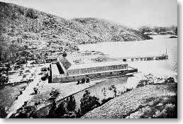 The
Emperor Dom Pedro II stayed in the Lazaret in three different
occasions: April, 1886; August, 1889; and soon afterwards, but then as
a prisoner waiting for the ship that would take him to exile. The
Emperor Dom Pedro II stayed in the Lazaret in three different
occasions: April, 1886; August, 1889; and soon afterwards, but then as
a prisoner waiting for the ship that would take him to exile.
Between 1886 and 1913, when the Lazaret
was abandoned, a total of 4232 ships disembarked their passengers
there. From these ships, 3367 were
disinfected. World's first single-handed around the world sailor,
Captain
Joshua Slocum, anchored his bark Aquidneck at Ilha Grande
in January 1887; chapters III and IV of his famous "Voyage
of the Liberdade" book offer a good description of what happened in those days. The Lazaret
then remained empty until 1935, only to be used again until 1939, as
lodgment for marines on military exercises. In such occasions, some 10 military ships could be found anchored at
Abraão bay. At night, when the marines got together, the local
community was transformed by the maracatu, a rythm and dance
typical of Brazil's northeastern states.
THE REPUBLIC AND THE PENAL COLONIES... 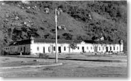 After
the Republic's proclamation, in 1889, or just three years after it was
first opened, the Lazaret needed remodelling. This was due to the
speed and conditions it was originally built, resulting in quick
deterioration. In that year, the 1,000 liters/hour aqueduct was also
built, its ruins still existing today. After
the Republic's proclamation, in 1889, or just three years after it was
first opened, the Lazaret needed remodelling. This was due to the
speed and conditions it was originally built, resulting in quick
deterioration. In that year, the 1,000 liters/hour aqueduct was also
built, its ruins still existing today.
In
1903, the Penal Colony of Dois Rios was officially installed, and was initially intended
to hold convicts judged for ordinary crimes. 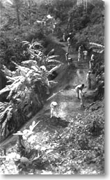 In
1940, the Lazaret once again underwent major remodelling, this time to
be transformed into a prison (Colônia Penal Cândido Mendes), and
designed to receive the ordinary convicts from Dois Rios. Dois Rios,
on the other hand, was to receive World War II's political prisoners,
initially transported to Fernando de Noronha island, in northeastern Brazil.
This was necessary because Fernando de Noronha had been lent to the U.S.Government
for use as a strategic military base. In
that same year, as the Lazaret and Dois Rios penal colony were being
remodelled, the road linking Abraão and Dois Rios was built. The
workers were ordinary convicts, and the necessary equipment was
transported by navy ships. The
Lazaret continued to be used as a prison until 1954, when all
prisoners were transferred back to Dois Rios, its name also being
changed to Colônia Penal Cândido Mendes. Soon afterwards, the
Lazaret was demolished following an order from State Governor Carlos
Lacerda. Only the aqueduct remained intact, although the rainforest is
slowly beginning to claim its land back.  It
is widely known that politicians, spys, foreign government
collaborators, and famous writers spent part of their lifes at Dois
Rios Penal Colony. Some, after regaining their freedom, settled in
Ilha Grande; others left their bitter jail memories to posterity
through their books. Among them are writers Graciliano Ramos and
Orígenes Lessa, and revolutionary Flores da Cunha and Agildo Barata,
among others. It
is widely known that politicians, spys, foreign government
collaborators, and famous writers spent part of their lifes at Dois
Rios Penal Colony. Some, after regaining their freedom, settled in
Ilha Grande; others left their bitter jail memories to posterity
through their books. Among them are writers Graciliano Ramos and
Orígenes Lessa, and revolutionary Flores da Cunha and Agildo Barata,
among others.
Dois
Rios was finally demolished in 1994, and although it initially was
said that a hotel and resort were interested in the area, fortunately
only the Rio de Janeiro State University (UERJ) was allowed to
establish an Environmet and Sustainable Development Study Center
there. Visitors are allowed until 17:00 only.
THE FISHING INDUSTRY...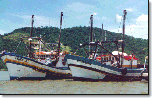 A
large portion of the island's inhabitants works in the fishing
industry. Major fishing nuclei are: Provetá, Araçatiba, Praia
Vermelha, Matariz, Praia do Longa, and Aventureiro. Aside Abraão and
some "private" beaches, the vast majority of the local
communities has in fishing its economic activity. Japanese
immigrants in the 30s started to salt fishes in an industrialized
basis, through a process originally introduced by Greek
immigrants. A dozen or so fish salting plants existed in Ilha Grande
until the 70s, but nowadays most of them were remodelled into pousadas.
SOURCES:
- Carl Egbert
Hansen Vieira de Mello. Apontamentos p/ a História do Rio
de Janeiro, Angra dos Reis e Ilha Grande.
- Projeto Ilha
Grande, Secr. Mun. de Des. Econômico, Social e
Planejamento, Gov. Neirobis Kazuo Nagae.
SOME
INTERESTING LINKS...
|