| HOME
| CONTENTS
|
| ABSTRACT
| BACKGROUND
| METHODOLOGY
| CHECKLIST
| DISCUSSION
| APPENDIX
| BIBLIOGRAPHY
|
| Natural
Heritage Value | Educational Values | Historic
Values | Recreational Values | Planning
and Development Considerations |
|Significant
Features | Non-native Species | Undesireable
Activities | Rehabilitation and Planting
| Trail Development |
DISCUSSION AND RECOMMENDATIONS
At present there is a proposal underway by the Grand Trunk Trail Committee:
"to convert the former Grand Trunk Railway line to a multipurpose,
accessible trial to compliment the surrounding environment, aesthetically
restore the "Sarnia Bridge", allow safe crossing of the Thames River, provide
a panoramic view of the town, and link with the existing River View Walkway".
This section of the report will serve to point out some of the values and
make recommendations concerning the development of the Grand Trunk
Trail and its linkage with the River View Walkway. Emphasis
is given to the development of a trail system that incorporates the natural
landscape as a major theme of the trail. It is hoped that the inventory
and the identification of the various vegetation communities and their
associated values will help to guide the development of this trail system.
Natural Heritage Values
Natural Heritage can be described as the natural landscape which provides
a number of functions which are a benefit to the public and contribute
to a better quality of life. Some of these functions include the
aesthetic appeal of our rural landscape, habitat for wildlife, hydrological
benefits, and economic products. The study area has a number of
natural heritage features which contribute to the natural heritage value
of the area. Features such as "Greenways" along the abandoned rail
line and the Thames River and the Dolomite Limestone outcrops found along
the River contribute to the overall uniqueness and aesthetic appeal of
the area.
When land settlement began in Perth County prior to 1850, almost the
entire land base was covered with trees. Because this vast expanse
of forest was an impediment to early settlers, land clearing began immediately
and increased at a rapid pace. By 1910 the amount of forested land
dropped to about 10 percent of the total land base. Blanchard Township
which encompasses the town of St. Mary's has 2.6 percent forest cover,
which is the lowest percent forest cover of any township in Perth County
(Smith, Undated). It can therefor be said that any forested areas
within Perth County have special significance and hold natural heritage
values.
The abandoned Grand Trunk Rail Line can be considered to be a "Greenway"
which is defined as vegetated anthropomorphic link between natural areas,
parks, or historic areas (Labaree, 1992). Greenways follow streams
and rivers, ridge lines, abandoned rail lines, hedgerows, canals, and other
transportation corridors. Greenways provide a number of ecological
functions such as:
1. Providing habitat for plant and animal communities.
2. Acting as a conduit for plants, animals (including
man), water, sediment, and chemicals.
3. Providing a physical barrier preventing movement
(usually perpendicular to its axis)
4. Acting as a filter preventing passage of some things
but not others.
5. Acting as a source. Providing the surrounding area
with a number of things.
6. Acting as a sink trapping sediments and nutrients
Educational Values
The abandoned Grand Trunk Rail Line lies within the town of St. Mary's
and thus is easily accessible to the public and in effect can provide a
natural classroom for learning. Two schools, Arthur Meighen and Holy
Name of Mary School (Figure 6) are closely situated to the abandoned rail
line, with Holy Name of Mary School actually abutting the abandoned rail
line property. The close proximity of the abandoned rail line to
area schools provides a unique opportunity for students to use the area
for hands-on educational projects. Projects such as habitat restoration,
exotic species control, and the development of a self guided interpretive
trail has the potential to increase the natural heritage value of the surrounding
area as well as provide educational opportunities for students at the same
time. Some of the educational values that can be derived from the
area include; natural history, botany, environmental studies, geography,
soil studies, dendrology, and biology. Schools may wish to
use the area as a living classroom to study natural processes such as plant
competition, nutrient recycling, habitat evolution, and predator prey relationships.
Historical Values
The proposed Grand Trunk Tail within the town of St. Mary's has the
potential to provide local residents, tourists, and other 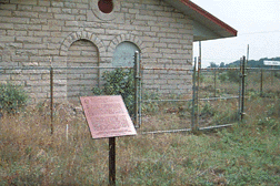 users
with a link to St. Mary's past. Historical features such as the Grand
Trunk Rail Line, the Junction Station, and the Sarnia Bridge could be highlighted
in interpretive displays and signage to increase the historical and educational
value of the trail. The Junction Station has been recognized by the Provincial
Government as a historical site and a plaque recognizing the structures
historical relevance has been erected by the province near the building
(Figure 11).
users
with a link to St. Mary's past. Historical features such as the Grand
Trunk Rail Line, the Junction Station, and the Sarnia Bridge could be highlighted
in interpretive displays and signage to increase the historical and educational
value of the trail. The Junction Station has been recognized by the Provincial
Government as a historical site and a plaque recognizing the structures
historical relevance has been erected by the province near the building
(Figure 11).
The Grand Trunk Railway in Southwestern Ontario was constructed
to provide a link between the railways Michigan lines and its eastern seaboard
terminus at Portland Main. A line from Toronto to Sarnia was completed
in 1859 (Andreae, 1972). Southwestern Ontario is strategically positioned
between the American Midwest and the New England States and provides the
shortest route between the two. The Railways built in this area were known
as the "Bridge Railways" of Southern Ontario. It is very unlikely that
the Grand Trunk would have been built in Southwestern Ontario as early
as it was if not for its strategic location.
Recreational Values
The proposed Grand Trunk Trail has good potential to provide various
recreational opportunities promoting fitness, stress relief, and well being
for local residents, tourists and other users. It is the opinion
of the author that recreational activities should be limited to those activities
that are compatible with each other, peaceful, and undamaging to the natural
surroundings. The following recreational activities are suggested
by the author as being consistent with this type of use;
- walking, running, and hiking - wildflower identification
- biking - environmental education
- nature watching - cross-country skiing
- photography - snowshoeing
The operation of motorized vehicles, excluding motorized wheel chairs,
along the proposed Grand Trunk Trail should be discouraged as it is damaging
and disruptive to the surrounding environment. Operation of motorized
vehicles along the trail would also cause conflicts between user groups
as well as pose a safety concern. In the opinion of the author the operation
of motorized vehicles along the proposed Grand Trunk Trail is not consistent
with a safe, undamaging, and peaceful experience with the natural surroundings.
In order for the proposed Grand Trunk Trail to provide recreational
opportunities for the widest range of people it is suggested that the grade
along the trail not exceed 5 percent (assuming a surface of hard packed
stone dust) in any location and that the needs of the elderly and physically
challenged be taken into consideration when designing signage, bridges,
boardwalks, handrails etc.
Planning and Development Considerations
Discussions regarding planning and development considerations are centered
around the development of the proposed Grand Trunk Tail and its linkage
with the River View Walkway. However, some discussion is given to
the further development of the existing River View Walkway to compliment
the proposed Grand Trunk Trail.
The information obtained from the inventory and assessment, which was
conducted as part of this study, is used here to determine points of interest,
site sensitivity, and areas of concern. The following development
proposals strive to respect existing natural resources while integrating
educational and recreational opportunities in the development of the Grand
Trunk Trail. By integrating the environmental, educational, and recreational
opportunities in a complimentary fashion it is hoped that a greater awareness,
enjoyment, and appreciation of the natural environment will occur.
Significant Features
The four vegetation communities identified within the study area (1.
old field, 2. deciduous forest edge, 3. riverine swamp shoreline,
4. riverine limestone pavement shoreline) although not considered
rare, should be considered significant as they provide a number of values
to the public as previously discussed in the Natural Heritage Values section.
It is suggested that the four vegetation communities identified from the
inventory be incorporated into interpretive signage and trail design to
promote educational and natural heritage values of the trail. As two of
the vegetation communities identified from the inventory occur along the
North Thames River it is suggested that the River View Walkway be enhanced
in an area along the limestone pavement shoreline vegetation community
to take advantage of this feature. An enhancement such as an outlook
with interpretive signage is suggested (Figure 6).
It is suggested that a link be created between the River View Walkway
and the Grand Trunk Trail. A suggested route for the linking trail
would be along the Water Street North bridge, into the Lions Club Park,
along the paved road following the North Thames River, and then linking
with the Grand Trunk Trail at either the Emily Street Underpass or somewhere
at the north end of water street depending upon availability of public
land ( Figure 6). The linking trail would use existing roadways and
appropriate signage to guide users to the Grand Trunk Trail. The
actual connection and access to the Grand Trunk Trail may present some
design problems as the Grand Trunk Railway rises over Emily Street in this
location to gain height to span the Thames River. It is suggested that
a trail head with parking be located within the Lion's Club Park to provide
access to the trail system. A second outlook created along the North
Thames River and within the Lions Club Park would provide a view
of the Sarnia Bridge, the North Thames River, and shoreline vegetation
communities. The outlook would also direct users to the access point
of the Grand Trunk Trail through the use of an interpretive map.
The two vegetation communities along the Grand Trunk Trail, "old field"
and Deciduous Forest edge, could be indicated with interpretive signage
at lay-by stations along the trail as indicated in Figure 6. The
"old field" interpretive station would be located at the proposed nature
studies and educational area close to Arthur Meighen and Holy Name of Mary
School .
No provincially rare species as defined in the Atlas of the Rare Vascular
Plants of Ontario (Argus et al., 1982-87) were found during the inventory.
However, rare species may exist within the study area as the inventory
is not exhaustive in nature. Regional rarity of plants identified
in the inventory could not be assessed with any accuracy as there is little
published information in this regard for Perth County. No published
flora for Perth County exists, although one is being worked on by Arnold
Wellwood and Terry McIntosh (M.J. Oldham 1993). A preliminary checklist
of Perth County flora compiled by Terry McIntosh of Wilfrid Laurier University,
Waterloo is incorporated into a draft copy of the "Distribution and Status
of the Vascular Flora of Southwestern Ontario" compiled by Mike Oldham
in 1993. This publication makes reference to flora in Perth County
as being either present and native or present and introduced only and therefor
cannot be used to assess rarity.
The only species of flora identified within the study area which may
bare some significance as a regionally rare species is the semi-aquatic
species Lizard's-tail (Saururus cernuus) which was identified along the
North Thames River in the vicinity of the Lions Club Park. Lizard's-tail
is listed in the "Distribution and Status of the Vascular Flora of Southwestern
Ontario" as being present in Perth, Oxford, and Huron Counties but being
either rare, unknown, uncommon, or very uncommon in Essex, Kent, Lambton,
Middlesex, Elgin, and Haldimand-Norfolk.
If upon further study rare plant species are discovered to be growing
along the Grand Trunk Trail, it is recommended that these species be identified
through interpretive signage. Interpretive signage should vaguely
reference the location of any rare species to protect them from molestation
and unscrupulous collectors.
Non-native Species
Approximately 42% of the total number of species identified in the inventory
were non-native. This is not surprising as vegetation within a railway
right of way is often heavily disturbed. Vegetation management activities
such as burning, mowing, and spraying promote the growth of invasive species
which often are non-native. Active rail lines often provide a mechanical
method of seed dispersal for non-native species as seeds are transported
in rail cars in the form of livestock bedding, forage, and manure.
Early settlers throughout Canada and the United States promoted the
growth of European forage grasses as they felt that their livestock did
poorly when raised on native pastures. To this day most roadsides,
lawns, and forage grass and legume mixtures consist of non-native species.
Many non-native species provide inferior wildlife food and habitat when
compared with other suitable native species. As well, some species
such as Purple Loosestrife (Lythrum salicaria) and Dog-strangling
Vine (Cynanchum rossicum) are so aggressive that they literally take over
an area leaving little desirable native habitat.
Some non-native species have been classified as noxious weeds under
the "Weeds Control Act." This act states that "every person in possession
of land shall destroy all noxious weeds thereon." Weeds are classified
as noxious for several reasons. Some are noxious because they reduce
crop yields; some because they are health hazards to either man or livestock;
and some because they increase crop diseases. Some of the more aggressive
non-native species that warrant control along the abandoned rail line and
along the North Thames River within the study area include Dog-strangling
Vine (Cynanchum rossicum), Purple Loosestrife (Lythrum salicaria), and
Common Buckthorn (Rhamnus cathartica). Dog- strangling Vine and Purple
Loosestrife have been recommended for removal as these plants are very
invasive and highly competitive. Once these plants are established
in an area they quickly take over and produce a monoculture of poor quality
wildlife habitat. Common Buckthorn is recommended for removal as
it is an alternate host for the fungus that causes leaf and crown rust
in agricultural oat crops (Alex, 1992)
The non-native Purple Touch-me-not (Impatiens glandulifera) is present
in great quantities under the Sarnia Bridge but as I am unaware of any
published information as to this species invasive behaviour or possible
noxious qualities I cannot recommend its control. The spread of
Purple Touch-me-not should be monitored and the appropriate control methods
used if warranted.
Not all non-native species are particularly undesirable, many species
such as Birdfoot trefoil (Lotus corniculatus), White Sweet-clover (Melilotus
alba), Yellow Sweet-clover (Melilotus officinalis), Red Clover (Trifolium
pratense), White Clover (Trifolium repens), and Cow Vetch (Vicia cracca)
are promoted as good quality livestock and wildlife forage which possess
good soil building and stabilizing qualities. Even though 42%
of the vegetation by species growing within the abandoned rail line is
non- native, these species provide a diversity of habitat and green space
within an urban environment and to this extent they are desirable.
It is suggested that an area near the two schools (Arthur Meighen and
Holy Name of Mary School ) be actively rehabilitated and managed as a natural
area to promote and increase the educational and natural heritage values
of the proposed Grand Trunk Trail. This management and rehabilitation
would require an active non-native species removal and native planting
campaign.
Undesirable Activities
Activities such as dumping, encroachment by adjacent landowners, and
operation of motorized vehicles reduces the value of a  trail
system for the public. Dumping along the abandoned rail line was
observed in several areas but was most noticeable along the back of Dresden
Industrial at the north end of Wellington Street. From an aesthetic
point of view dumping of debris and garbage detracts from the trail user's
visual experience. Dumping also eliminates habitat for plants and
animals and reduces the area's natural heritage value.
trail
system for the public. Dumping along the abandoned rail line was
observed in several areas but was most noticeable along the back of Dresden
Industrial at the north end of Wellington Street. From an aesthetic
point of view dumping of debris and garbage detracts from the trail user's
visual experience. Dumping also eliminates habitat for plants and
animals and reduces the area's natural heritage value.
Encroachment onto the railway right of way is believed to be taking
place just west of James Street North on the
south side of the railway right of way (Figure 12). Landowners
in this area have "cleaned up" existing natural vegetation by mowing and
creating rock gardens.
The operation of Motorized vehicles along the abandoned rail line does
not appear to be prevalent but as vehicle barriers are non existent or
are somewhat rudimentary in places, access by motorized vehicles is occurring
on an infrequent basis. It is hoped that as the Grand Trunk Trail
is developed adjacent landowners and users alike will develop an appreciation
for the trail and undesirable activities will cease. A management
plan for the Grand Trunk Trail should be developed which would clearly
state what types of activities are undesirable.
Rehabilitation and Planting
A management plan should be developed that would identify areas to be
rehabilitated as well as where additional tree planting is to occur.
It is the opinion of the author that all rehabilitation and tree planting
should be done with native species which are well adapted to local conditions.
Memorial tree planting is becoming a popular way in which to recognize
a person's achievements or as a way of leaving a living legacy in memory
of a loved one. This type of planting is probably best suited to
formal gardens and manicured lawns and thus may be best suited to sites
like the River View Walkway or incorporated into the proposed Peace Gardens
at the west end of the Grand Trunk Trail (Figure 6). It is suggested that
trees used for memorial planting should also be native species.
Based upon St. Mary's bordering position between the Carolinian Zone
and the Great Lakes - St. Lawrence Deciduous Forest Region and considering
local soil types, a list of native trees and shrubs suitable for planting
in rehabilitation areas and memorial groves was developed. This list
is presented in Appendix I.
Trail Development and Management
It is beyond the scope of this report to provide a management plan for
the development of the Grand Trunk Trail. However, it is highly
recommended that a comprehensive trail development and management proposal
be developed by the proponents of the Grand Trunk Trail if this project
is to proceed. This proposal with extensive input from local users groups,
adjacent landowners, and other interested parties should address the following
topics:
- ownership and responsibility
- legal liability
- zoning bylaws and planning issues
- budget and costing
- development strategies (ie. Phased development)
- permitted uses
- access restrictions
- access points (trail heads)
- integration with other trail systems
- emergency vehicle access
- Disabled access
- night use and lighting
- private property and fencing issues
- signage
- maintenance
- parking areas
- structures (bridges, boardwalks, stairs, ramps, benches, guardrails,
access barriers, etc.)
- surface treatment
- natural area rehabilitation
- tree planting
-linkage with other trail systems (ie. Avon Trail)
| HOME
| CONTENTS
|
| ABSTRACT
| BACKGROUND
| METHODOLOGY
| CHECKLIST
| DISCUSSION
| APPENDIX
| BIBLIOGRAPHY
|
| Natural
Heritage Value | Educational Values | Historic
Values | Recreational Values | Planning
and Development Considerations |
|Significant
Features | Non-native Species | Undesireable
Activities | Rehabilitation and Planting
| Trail Development |