PHYSICAL AND HISTORICAL BACKGROUND
The area of study for this inventory and assessment is located in the town of St. Mary's which is located in Blanchard Township within Perth County. St. Mary's lies approximately 170 kilometers South West of Toronto, Ontario ( Figure 1 ). Figure 2 (derived from Ontario Ministry of Natural Resources, Cambridge District mapping, 1997) depicts the town of St. Mary's on a regional scale. By examining Figure 2 a corridor effect created by woodlots can be seen , these woodlot corridors were created by the clearing of forested land for agricultural purposes. Woodlot corridors are important as they provide habitat and travel routes for wildlife (see Natural Heritage Values section).
This inventory covers two connecting areas. The first area consists of the proposed Grand Trunk Trail in the town of St. Mary's, from the Junction Station to a point adjacent to the nursing home on Ann Street ( Figure 3). The area inventoried along the proposed Grand Trunk Trail included all the area within the railway right-of-way (approximately 66 feet wide) and naturalized areas around the Junction Station. The second area inventoried included the area under the east and west sides of the Sarnia Bridge as well as the natural shoreline along the east side of the North Thames River through the Lion's Club Park, along "the flats," and the River View Walkway, to the tennis court parking lot.
The physiography of the St. Mary's area is underlain by bedrock of Silurian and Devonian ages. These formations extend in belts trending almost north-south and dip gently westward toward the Michigan Basin. These bedrocks from east to west, and oldest to youngest are; the Amherstburg Formation, brown limestone and dolomite in a small area near Stratford; the Lucas Formation, brown limestone and dolomite east of a line through St. Mary's and Dublin; and the Dundee Formation, gray to brown fossiliferous limestone under the remaining western part of the area (Karrow, 1977).
Quaternary deposits 30 to 100 meters thick cover the bedrock in most of the area; however, bedrock outcrops can be seen in quarries belonging to the St. Mary's Cement Company as well as the North Thames River South of Motherwell and at the base of the Trout Creek Valley.
A major geomorphic boundary is present along the North Thames River Valley. To the east, glacial ice movement was southeast, resulting in parallel eskers and northeast trending moraines. To the west, glacial ice movement and associated eskers are eastward with end moraines trending north-south. This geomorphic unconformity strongly affects local drainage characteristics.
St. Mary's is located within the Stratford Till Plain Physiographic Region (Chapman and Putnam, 1973). The Stratford Till Plain is a large, level to slightly undulating till plain which slopes slightly to the southwest. The Stratford Till Plain is modified slightly by lacustrine sedimentation and interrupted by several terminal moraines. The till is a uniform brown silty- clay to silt texture and appears to be derived predominantly from Huron Lobe carbonate bedrock flour. Lacustrine silt and clay deposits cover extensive areas on this till sheet.
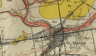
A general description of the soils found in the St. Mary's area and
their distribution can be determined by examining Figure 4 (Hoffman
and Richards, 1952). Soils in the St. Mary's area are derived from
subaqueous clay tills which were originally deposited by glacial ice but
were then modified by lacustrine waters, making them less stony than
many other glacial ice deposits. These tills are derived from limestone
and thus soils in the St. Mary's area are well buffered and fertile.
As seen from Figure 4, soils within the inventory area consist of Huron
soils (Huc), Perth soils (Ps) and Bottom Land soils (B.L).
Huron (Huc) soils occupy rolling to steeply sloping sites. Because
of their topography, runoff is rapid and drainage is good. Blocky
structure through the soil profile provides for moderate water infiltration
rates and a water holding capacity which maintains moisture at levels adequate
for plant growth even during the drier times of the year. Huron soils
are very susceptible to erosion and may have suffered loss of the upper
soil horizons along river banks or in less steeply sloping areas where
vegetation cover is slight. Huron (Huc) soils are typically dark
silt loams or clay loams four to five inches in depth.
Perth (Ps) soils are like those of the Huron catena except for slope and drainage. Generally, slopes on Perth soils vary from 3 percent to flat. Infiltration rates of water through the loam and clay loam surface horizons are moderate to slow and runoff rates are medium. As a result, Perth soils are imperfectly drained and remain saturated for eight months of the year. Perth (Ps) soils can be found within the inventory area near the Junction Station and are typically dark grey clay loams or silt loams six inches in depth.
Bottomland (B.L) has been shown in Figure 4 wherever the land is subject to periodic flooding. Bottomlands occur in flood plains adjacent to creeks and as might be expected are variable in texture, drainage, and composition. Bottom land soils are present within the inventory area along the North Thames River.
There are nine forest regions within Canada which are based upon differences in terrain, soil, and climate. The inventory area according to a series of papers published by Sherwood, Fox, and Soper (1952-55) lies about 0.5 kilometers north of the Deciduous Forest Region's (Carolinian Zone) northen limit putting the inventory area within the Great Lakes-St. Lawrence Forest Region. The border between the Carolinian Zone and the Great Lakes-St. Lawrence Forest Region has been mapped by various authors with slightly differing borders and varying degrees of scale and accuracy. For example Hosie's (1969) mapping of the Forest Regions of Canada puts the northern limit of the Carolinian Zone slightly north of Soper's (1952) mapping. Hosie's mapping also includes two areas of Carolinian Forest not present in Sopers mapping. These two areas include an area along the east shore of Lake Huron up to Goderich and an area along the north shore of Lake Ontario to Bellville. Hosie's mapping would seem to include the southern portion of Perth County and thus would include St. Mary's and the inventory area within the Carolinian Zone.
Forest communities within the Carolinian Zone are dominated by broad-leaved trees. The characteristic association, common in part to both the Great Lakes - St. Lawrence Forest Region and the Carolinian Zone, consists primarily of beech and sugar maple, together with basswood, red maple, red oak, white oak, and bur oak. Also within this zone is found the main distribution in Canada of black walnut, sycamore, swamp white oak, and shagbark hickory, with the more widely distributed butternut, bitternut hickory, rock elm, silver maple, and blue beech. Other species with a sporadic occurrence on specialized sites are the following: tulip tree, black cherry, mockernut and pignut hickories, chinquapin oak, pin oak, black oak, black gum, blue ash, cucumber tree, pawpaw, Kentucky coffee-tree, red mulberry, and sassafras. The sweet chestnut used to be present before the chestnut blight removed it from the forest community(Rowe, 1972).
The Great Lakes-St. Lawrence Forest Region is bound in the north by the contact between Ordovician limestones of the Ontario Peninsula and the ancient Granite rocks of the Precambrian Shield and is marked by the distribution limits of such species as sycamore and black walnut which enter from the south and jack pine from the north. Common throughout this Forest Region are sugar maple, beech, basswood, white and red ashes, yellow birch, red maple, and red, white, and bur oaks. Frequently eastern-hemlock, eastern white pine, and balsam fir occur within the tolerant hardwood types with scattered largetooth aspen, butternut, bitternut hickory, hop hornbeam, black cherry, sycamore, and black oak. Blue beech, silver maple, slippery and rock elms, and black ash are found locally on flood plain and wetland sites. Eastern white cedar is present in swampy depressions and on old fields. In the Thousand Islands area at the eastern extremity of the Forest Region pitch pine grows on dry slopes and ridges (Rowe, 1972).
Figure 5 describes the relationship between the Carolinian Zone according to Gorrie (1994) and the inventory area within the town of St. Mary's. The Carolinian Zone according to Gorrie's mapping extends somewhat further north than Soper's description but does not contain the previously described
extensions by Hosie along the eastern shore of Lake Huron or the northern
shore of Lake Ontario.It can be expected that the inventory will contain
species indicative of both the Carolinian Zone and the Great Lakes-St.
Lawrence Forest Region as St. Mary's lies along the border of both of these
regions.
| HOME
| CONTENTS
|
| ABSTRACT
| BACKGROUND
| METHODOLOGY
| CHECKLIST
| DISCUSSION
| APPENDIX
| BIBLIOGRAPHY
|
| Location
| Physiography | Soils
| Forest Region |