|
Navigation |
|||||||||||
|
DESTINATIONS Lancaster Fox |
|
|
Navigation |
|||||||||||
|
DESTINATIONS Lancaster Fox |
|
© all photos (2000-2002), all rights reserved (Bob and Esmeralda Grove)
"Willie Jay" is where I learned to fly. And what a place it can be...winds 20 knots gusting to 25 with a 20 degree cross wind can be the norm around here. I heard of an experience pilot (but had never been here before) being blown into the dirt to the right of the runway just as he was touching down. Watch your flair and pay attention to your taxi skills. The winds don't usually kick up until the afternoon but it is a rare day in Lancaster when the wind is not blowing. Add a little density altitude and you have a good place to practice. I usually do all my touch and goes here because it gives me a chance for tower work besides cross wind landing practice.
The runway is now over 7 thousand feet so take your time during cross wind landings. The extra length helps the forest service fire fighting planes that are based here from May until the fire season ends. The fire fighting base is to the East of the airport, just West of Apollo Park. Apollo Park makes a good landmark as its lakes are just to the East of the field.
Other landmarks to look for are Palmdale Regional airport 6 miles to the Southeast and Rosamond Skypark 8 miles to the North. (see the Rosamond link) Also look for the 14 freeway that runs North and South around 3 miles to the East of the field. In fact the tower will often have you report over the freeway so try not to confuse it with Sierra Highway which is a large road just to the East of the freeway. A California State Prison is located a few miles to the Southwest and can be confused for Fox at night as it is lit up better than Fox. It makes a good landmark day or night.
Below are thumbnails of some other pictures taken around the area. Click on them to view the full size picture. Use your back button to return to this page.
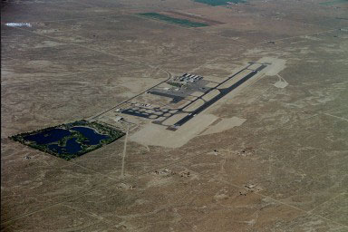 Fox
field looking Southwest. Note Apollo Park to the East.
Fox
field looking Southwest. Note Apollo Park to the East.
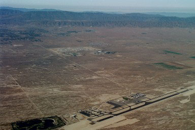 Also looking Southwest but you can see
surrounding terrain better.
Also looking Southwest but you can see
surrounding terrain better.
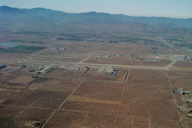 Palmdale airport (plant 42), Southeast of Fox.
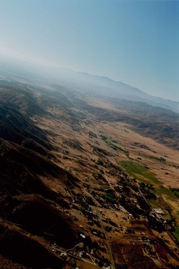 San Andreas Fault looking East (just 6 miles to
the South of Fox).
San Andreas Fault looking East (just 6 miles to
the South of Fox).
Fox Links
Contact me at: [email protected]
