|
Navigation |
|||||||||||
|
DESTINATIONS Tehachapi |
|
|
Navigation |
|||||||||||
|
DESTINATIONS Tehachapi |
|
© all photos (2000-2002), all rights reserved (Bob and Esmeralda Grove)
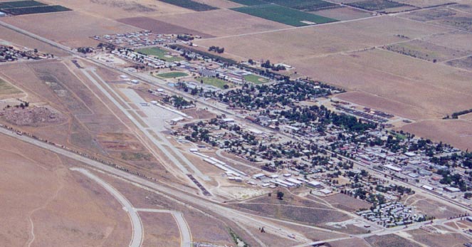
On June 20, 2000, My wife and I flew over Tehachapi Municipal. We were coming back from a morning spent at Kern Valley airport. I've over-flown Tehachapi many times but have never landed there. But I have driven to Tehachapi many times and thought I would include the airport in my destination guide. At least you the reader and pilot will have a couple of pictures to help prepare you for the flight.
My first trip to Tehachapi was as a railroad enthusiast. Tehachapi is home to the "Tehachapi Loop". The loop was built over a hundred years ago and was designed to allow a train to climb up the grade from the Tehachapi area into the Antelope Valley, more specifically, the town of Mojave. The cool thing about this loop, is that if the train is long enough, the front of the train passes over its own tail (see picture below). You can read about the loop by checking out the link below.
My family also heads up to Tehachapi to pick fruit. Berries in the summer and apples in the fall. As a hiker, I've also checked out the section of the Pacific Coast Trail that also is in the area.
Tehachapi is about a 20 minute flight from my home base of Rosamond. I just point the nose to the Northwest and avoid the large mountain on my left which is 7,981 ft high. I have to fly over a 4,000 ft. ridge directly to the East of the airport - this is the same ridge that necessitated the Tehachapi Loop for trains. The high point of crossing this ridge is the hundreds of windmills that cover its brown surface. The windmills are there for a reason - it's windy! Winds from the Tehachapi area converge on the winds of the Antelope Valley and things are almost always bumpy in this area. Throw in some convection and you can bounce around a bit in the afternoons and early evenings.
As you are passing over the windmill ridge you should notice the large cement plant to your Northwest. It has a huge dome and several tall stacks. Now just follow highway 158 for a few miles and you're there. The airport lies just to the South of the highway. If you're getting tired of the heat where ever you live, try the cool mountain air of Tehachapi.
Below are thumbnails of some other pictures taken around the area. Click on them to view the full size picture. Use your back button to return to this page.
![]() TSP
looking East.
TSP
looking East.
![]() Windmills
East of TSP.
Windmills
East of TSP.
![]() The
Tehachapi Loop (borrowed from the web, no photographer listed to give credit).
The
Tehachapi Loop (borrowed from the web, no photographer listed to give credit).
Tehachapi Links
The City of Tehachapi Web Page
Contact me at: [email protected]