|
Navigation |
|||||||||||
|
DESTINATIONS Laughlin |
|
|
Navigation |
|||||||||||
|
DESTINATIONS Laughlin |
|
© all photos (2000-2002), all rights reserved (Bob and Esmeralda Grove)
On May 27, 2000, I approached Laughlin from the West. From Rosamond, I flew an almost direct route to Laughlin passing the cities of Victorville and Barstow. Just because I like technology, I used the AOPA web site and their link to Duats to flight plan my trip. I enjoy doing everything at my desk and getting a print out of my flight plan - instead of calling Riverside and writing it in as I'm talking to a briefer. I'm still not that sophisticated with Duats, so invariably my flight plan is a bunch of VORs and victor airways. In this case, it is not a bad idea as pilotage can be pretty tough in the 192 plus miles of desert that lies between Lancaster and Laughlin.
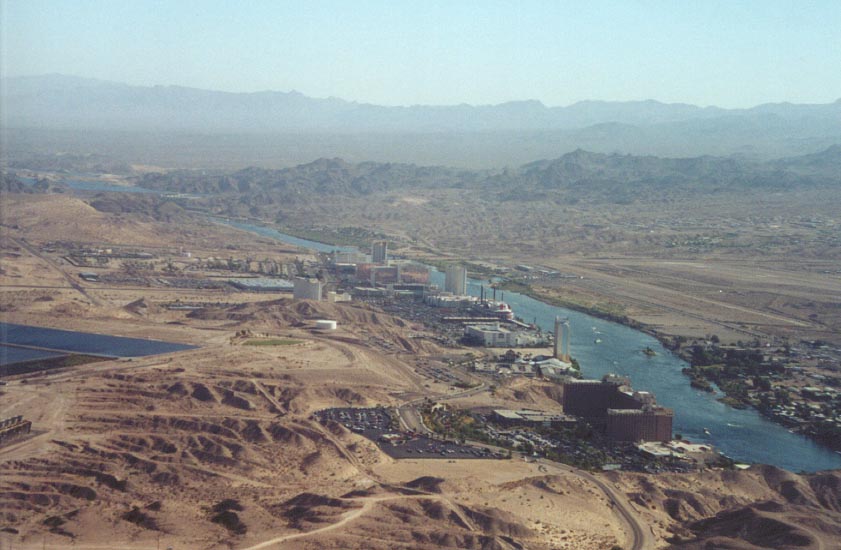 (Entering
Right 45, runway 16; looking Northeast - Laughlin on left side of the
river, the airport on the right side)
(Entering
Right 45, runway 16; looking Northeast - Laughlin on left side of the
river, the airport on the right side)
As much as I like technology, I still haven't sprung for a GPS yet but I love to use pilotage and VORs for navigation. The Arrow I fly also has a DME and a LORAN, and I'm a strong believer in using everything in the airplane to make a destination. The first leg of my flight plan has me flying direct from Rosamond to Palmdale VOR, a distance of only 16 miles. Then making a 90 degree left turn to fly V12 on a 067 degree heading. That's pretty wasteful of time, so I dial in the Palmdale VOR and preset it for 067 and fly until I intercept this radial. The Interception comes over the town of Lake Los Angeles, a town without a lake, 20 miles East of Palmdale. This saves me a lot of time as I don't have to spend the 16 miles heading South to Palmdale VOR just to turn East.
I need to stay on this radial for 79 miles until I fly over Hector VOR. I have two VOR receivers in this aircraft and I have both set on Palmdale. I do this to see if both receivers match. If they do, I use the other receiver to dial in the next VOR, in this case, Hector. However, my receivers don't match and I realize I'm going to have to squawk one of the receivers in my rental Arrow. So I elect to keep both receivers tuned to Palmdale and use landmarks to find out which receiver is the correct one. Flying V12 takes me just North of El Mirage dry lake, the twin Silver lakes of the Mojave River, and the town of Barstow with Barstow-Dagget (DAG) airport just to the North of my flight path. Pretty good landmarks on this leg of my journey. I now tune both VOR receivers to Hector, as well as my DME and I begin searching for a large white "bowling pin" on the ground below me. I guess it is silly, but I still get a big thrill at looking down and seeing the bowling pin or VOR on the ground, right where my flight plan calls for it to be.
My flight plan now calls for me to start heading Northeast and fly V8 at 057 degrees. I need to stay on this radial for 67 miles until I hit my last VOR, Goffs - and believe me, landmarks are few and far between on these 67 miles. There is a good dry lake bed about 12 miles NE of Hector, that helps. But what I find to be the best landmark is the railroad tracks that lead past the town of Kelso. They have a nice southerly bend in them that is easy to see in the air, not to mention the giant sand dunes to the Southeast. Do look for the town of Kelso, but on my two trips to Laughlin, I've never seen it and it is directly in my flight path.
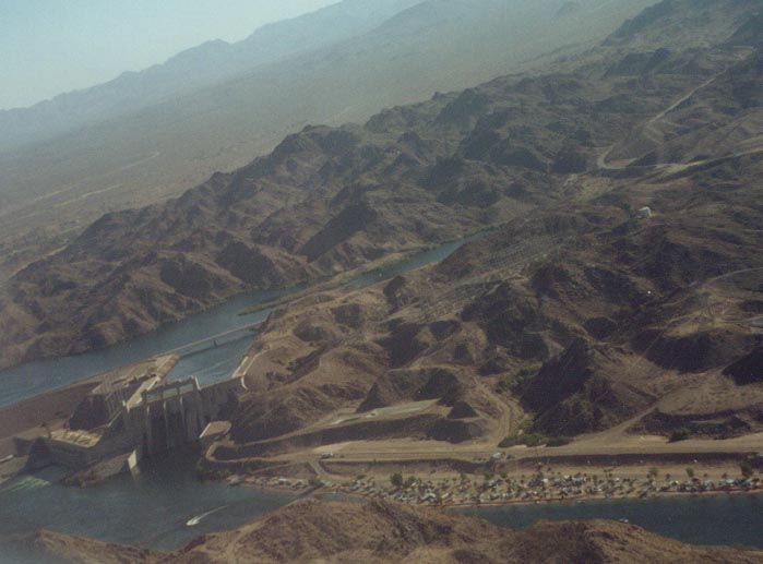 (Turning
Right Base, runway 16; Davis Dam and Lake Mojave)
(Turning
Right Base, runway 16; Davis Dam and Lake Mojave)
When I reach Goffs VOR, it is time to turn more Easterly again and fly direct to Laughlin. This is about the time I start cursing the fact that Laughlin lies right on the boarder of the Los Angeles sectional, with the important part off the map. You now have to fumble for the Phoenix sectional to see it all. I always wonder why everywhere I fly seems to fall on the edge of the map. But I do love this last part of my flight. If it is clear, and it usually is, you can see a tiny slice of river in the distance - the Colorado. You fly over a 2500 foot plateau, that drops nearly 2000 feet as you make the final approach to the river. My flight plan brings me right over the "Big Bend" in the river.
I use flight following on all my cross country flights and this one is no exception. I start with Joshua Approach (124.55) and they hand me off to LA Center, somewhere around Barstow. I stay with LA Center late, until I reach the 2000 foot drop off to the River. This gives me about 15 miles to work out things with the tower. The tower has me set up for right traffic, runway 16, and I enjoy flying the downwind leg over the river, between the airport and the Casinos on the Nevada side (the airport is on the Arizona or East side of the Colorado River). The views are great here - Lake Mojave to the North with Davis Dam right in front of you and a good spot to turn base.
Things to look out for as you approach Laughlin (the airport is Bullhead City and you can now make radio calls just using "Bullhead", instead of Laughlin - Bullhead) is the big bend in the river just a couple miles South of the airport and the power plant just SW of the airport (West side of the river). Your AFD will recommend you stay clear of the power plant and one look at the height of the smoke stacks should reinforce that recommendation for you.
Our Memorial Day trip found temperatures of 116 degrees F, so flying in the morning might be helpful. Also, be sure to cover your pitot tube - I didn't, and a sweat bee climbed inside and made a nice nest. If you want an airspeed indication, this doesn't help. After a three hour delay trying to leave on Monday, the tower told me that an A & P for a medivac helicopter outfit on field was willing to help me out. The A & P, Bart Kemp, was a life savior as he spent an hour on the hot tarmac cleaning out my pitot tube, while my wife and daughter laid on the ground under the right wing - my nine year old daughter was not a lesson in patience.
All in all, flying to Laughlin is a great trip. As a high school geology teacher, I lover to see the "bare bones" of the Earth revealed in the desert landscape of the East Mojave.
Below are thumbnails of some other pictures taken around the area. Click on them to view the full size picture. Use your back button to return to this page.
![]() Kelso
Dunes; Looking Southeast
Kelso
Dunes; Looking Southeast
![]() The
road to Kelso; Looking North
The
road to Kelso; Looking North
![]() Left
side of the "Big Bend"; Looking Northeast. Note the power
plant left middle
Left
side of the "Big Bend"; Looking Northeast. Note the power
plant left middle
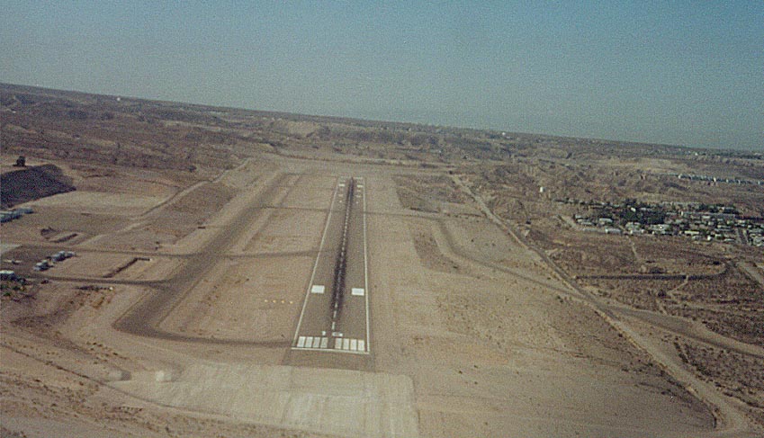
![]() Short
final, runway 16. Note long taxiway on right of runway
Short
final, runway 16. Note long taxiway on right of runway
![]() Entering
Right 45, runway 16; looking Northeast
Entering
Right 45, runway 16; looking Northeast
![]() Turning
Right Base, runway 16
Turning
Right Base, runway 16
Laughlin Links
Sheble's Aviation; Good airport info
Contact me at: [email protected]