Contents Beinn
Alligin / Beinn Dearg / Baosbheinn and Beinn an Eoin / Loch
Maree and Loch Ewe (1-4) The Fairy Lochs / Gairloch beach / Beinn
Airigh Charr / Inveran (5-8) Gairloch
Pier / Fishing boats / Red Point salmon fishing
station Kerry
Fish Farm / Loch Garbhaig hydro scheme / Gairloch Quarry
(25-28)
| Next
page | Top
of page | Home
page |
(811715, south)
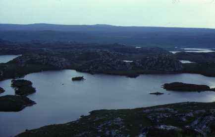
The landscape here (8171) is the result of erosion of Lewisian Gneiss. It is known as knob and lochan topography. The knobs or small hills surround water filled hollows, the lochans. These are known locally as the Fairy Lochs. In the background (7966) is an extensive area of peat moorland. This peat has developed since the glaciers melted and is formed by the accumulation of dead vegetation over the last 12000 years.
| Top of page | Home page |
(804758, southeast)
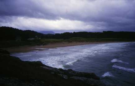
Raised beaches, formed by the change in the level of the land and the sea after the ice age, are useful areas of flat land in a hilly area. This one near Gairloch (8075) is made of sand dunes and used as a nine hole golf course. This dull slide shows another aspect of the physical geography of Gairloch. Being an exposed coastline, winds are often strong, and rainfall is high at around 1500 m.m. a year. The sea is rough with the strong winds. In the background low cloud obscures the top of Baosbheinn (8567).
| Top of page | Home page |
(892772, southeast)
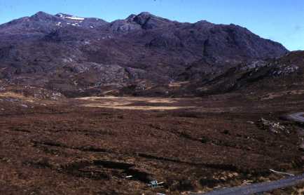
The natural vegetation of the area has changed over the centuries. Once much of the area was covered with forests but heather and coarse grasses, seen in this photograph, are the main vegetation types now. Soils are poor, acidic and peaty. A peat bank, where peat is cut to be dried for fuel, is in the middle foreground. The rest of the area supports sheep and red deer. The deer are fed by the road (on the right) during the winter months and are managed by the estates to provide shooting. This provides an important source of income and employment for many estates. In the background is Beinn Airigh Charr (9376).
[The cutting of peat is far less common now even compared with 1989]
| Top of page | Home page |
(862777, northeast)
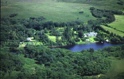
This view looks down on Inveran (8778) which is a large house owned by the estate owners. It is surrounded by a garden but also by natural birch and oak woodland. The water is the source of the River Ewe where it flows from Loch Maree. It is a good river for salmon and trout and, being only four kilometres long, is one of the shortest major rivers in Scotland. The fishing on both the river and the loch provides employment requiring people to take visitors fishing and to look after the river.
[Fishing has been very poor in recent years and this has had a knock-on effect on employment.]
| Next page | Top of page | Home page |