Contents Beinn
Alligin / Beinn Dearg / Baosbheinn and Beinn an Eoin / Loch
Maree and Loch Ewe (1-4) The Fairy
Lochs / Gairloch beach / Beinn Airigh Charr / Inveran
(5-8) Loch Maree islands (9-12) An Dùn, Gairloch / South Erradale
/ Opinan Gairloch
Pier / Fishing boats / Red Point salmon fishing
station Kerry
Fish Farm / Loch Garbhaig hydro scheme / Gairloch Quarry
(25-28)
| Next
page | Top
of page | Home
page |
(892772, south)
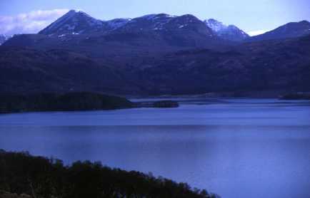
In the foreground is the natural birch woodland (8976). Some of the islands have remains of the natural Caledonian Forest that once covered much of the Highlands. The island (8973) visible on this slide and the area in the background are part of Slattadale Forest (8971), owned by the Forestry Commission. Some of its conifers have reached maturity and are being felled. Amenities for tourists have been provided; these include a car park, toilets, picnic site and walks. Beinn an Eoin (9064) in the background is a reminder of the glacial features of the landscape.
Section B: settlement, agriculture and services
| Top of page | Home page |
(803752, northwest)
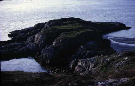
The Gairloch area has been settled since early times. Examples of hut circles are to be found in the area though the only archaeological feature shown on the 1:50,000 map extract is that shown in this photograph. This is An Dùn, a stronghold on the headland at the south end of Gairloch beach (804750). The remains of walls are visible on the grassy top. Other evidence of early settlement can be seen in place names. While many are Gaelic or anglicised versions of Gaelic, there are examples of Viking influence, e.g. Longa, Ship Isle (7377); and Shieldaig, Herring Bay (8072) as well as the names ending in 'dale'.
[Shieldaig is probably better translated as 'bay with an island']
| Top of page | Home page |
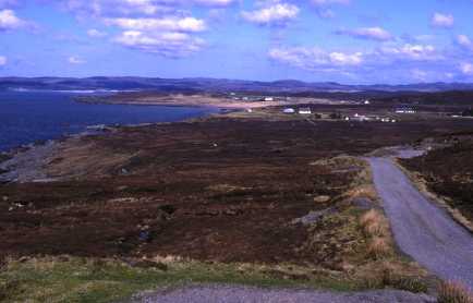
(733704, northeast)
This is a general view of South Erradale (7471) taken from the south. South Erradale is best described as a crofting township. The houses have been built on the crofts rather than being clustered together as in a village. Most of the main settlements in the area are to be found on similar sites. They are built on the raised beaches which are composed of better soils than the rest of the area. Crofting, a form of subsistence farming of crops and animals on poor land, and fishing were the main supporters of the population. Now, while crofting continues, other jobs provide an income and a higher standard of living. Providing 'bed and breakfast' for tourists in the summer is a further source of income.
[It is very unusual to see crops being grown and silage is the only crop harvested in any quantity.]
| Top of page | Home page |
(747730, south)
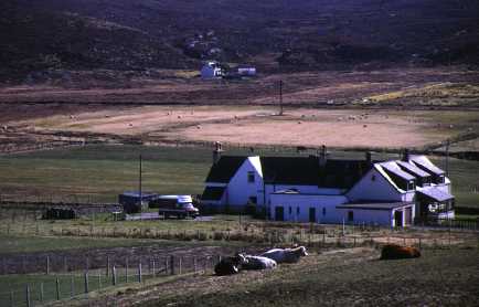
Nearby is another township, Opinan (7472). This photograph shows cattle and sheep kept by crofters. A typical one and a half storey croft house can be seen in the background, near the landward limit of the raised beach. The flat land would have been cultivated in the past and may still be used to provide hay though this is usually bought nowadays. The land is not as well tended as in the past; rushes in the fields in the top right indicate that drainage is poor. Beyond the flat area, the land rises and is heather covered. This provides grazing land and is termed 'common grazing'. This means each crofter has a right to graze animals on this unfenced land. It is poorer than the raised beach; the heather is burned every few years to encourage young shoots to grow and improve the nutritional value of the land.
The population of this area has decreased and with improved roads, there is no need for small schools to serve every village. The large building in the foreground is an old school. It has been converted into a house and is seen here being served by a butcher's van, one of the mobile services that operate in the area. Others include fish, fruit and vegetable; groceries; clothes and bank.
| Next page | Top of page | Home page |