Contents Beinn
Alligin / Beinn Dearg / Baosbheinn and Beinn an Eoin / Loch
Maree and Loch Ewe (1-4) The Fairy
Lochs / Gairloch beach / Beinn Airigh Charr / Inveran
(5-8) Gairloch
Pier / Fishing boats / Red Point salmon fishing
station Kerry Fish Farm / Loch Garbhaig hydro
scheme / Gairloch Quarry (25-28) Gairloch
| Top
of page | Home
page |
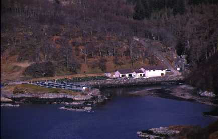
(805736, northeast)
Kerry Fish Farm (812738) opened in 1986 and lies at the mouth of the River Kerry. It specialises in the production of young salmon known as smolts. The building contains the offices and laboratories as well as the tanks where the eggs are hatched. The young fish are moved to the outside tanks once their weight reaches one gram. When the smolts reach maturity, they are transferred to a special boat using a flexible pipe to minimise disturbance during the operation. The smolts are sold to fish farms around the Highlands and Islands for rearing in sea cages.
| Top of page | Home page |
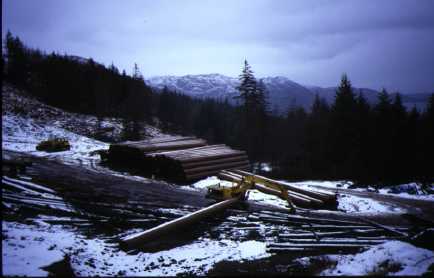
(894705, northwest)
The area has great potential for hydro electricity power generation. The River Kerry has been developed downstream of L. Bad an Sgalaig (8571) and there have been proposals to build a scheme in Srath Lungard (9265). This view shows a 'run of the river' hydro scheme (894705) under construction on the river leading from L. Garbhaig (8969) in Slattadale Forest.
[This scheme is in operation. Another proposal, which is awaiting a report following a public enquiry, is to tap the waters flowing from L. a' Bhealaich (8664). This has been greeted with protests from environmental and walking groups because of its possible environmental impact.]
| Top of page | Home page |
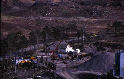
(817777, northeast)
This photograph shows a number of developments. The quarry (817778), in the foreground, supplies road and building materials for the surrounding area. It crushes glacial moraine and rock from the adjacent hillside to produce different sizes of aggregate. In the background is the rubbish dump for Gairloch and surrounding settlements. It is now full and a new one has been opened next to the quarry. The old dump caused concern because of the pollution of the river flowing to Gairloch.
The last three slides contain features not shown on the O.S. map extract which, though dated 1987, has not been revised since 1976. A further major change has been improvements to the roads. Reference to slides 18 and 27 both show roads that have been doubled since the map was drawn.
[The quarry is not in regular use and only supplies stone for large orders. The new dump referred to above is now closed because it does not meet the latest environmental standards. All refuse from the area is transported to Inverness for disposal.]
Section E: summary
| Top of page | Home page |
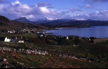
(798776, southeast)
These slides have shown aspects of the geography of a North West Highland area. Its physical geography is dominated by glaciated mountain scenery. The population that it supports is mainly settled on the coast in townships scattered along the raised beaches. The economy depends on tourism though other industries such as fishing, fish farming and construction provide important jobs.
| Top of page | Home page |