| Next page | Top of page | Home page |
(797600, north)
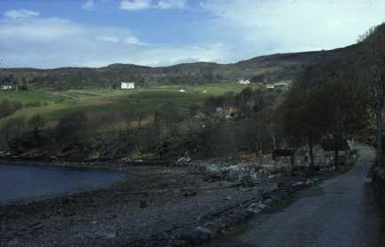
Diabaig (7960), in the far south of the map extract, is a crofting township on steeper land. The road linking it to Torridon is twisting and has a number of very steep hills (as can be seen in 7960). The township has benefited recently from the development of fish farming and this now employs workers on the fish cages in the sheltered sea loch immediately to the south of the map.
| Top of page | Home page |
(846718, northeast)
The daily postal service to Gairloch is provided by a postbus. This and a daily bus are the only public transport in and out of the area. Many of the roads around Gairloch are still single-track with passing places to allow other cars to pass and overtake. The main A832 is gradually being upgraded though it will be many years before all of it is double-track. The postbus is seen passing Gairloch Dam (847720), built in 1949 to increase the size of L. Bad an Sgalaig, which feeds the small hydro-electric power station of Kerry Falls (829719). Its 1250 kilowatt output originally served the area but now a 33 kilovolt line linked to the National Grid supplies the extra needed. The effect of the power station is that the course of the river, including the waterfall (838720), between the dam and power station is dry except after prolonged rain.
[The postbus ceased running in 1998. A number of extra services between outlying areas are run aided by the government's Rural Transport Initiative and a summer service operates twice a week in both directions between Inverness and Ullapool]
| Top of page | Home page |
(812761, northwest)
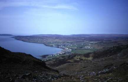
Gairloch is the main settlement in the area. It has a population of around 800 though this increases significantly in the summer with the influx of tourists. Its site on a raised beach can be seen. Beyond, the crofting township of Lonemore (7877) displays the typical dispersed settlement pattern. The island of Longa (7377) is centre left and in the far distance are the Outer Hebrides.
[The population of the area rose by 11% between 1981 and 1991 and, for the area of the map quadrant, is around 1000 in total]
| Top of page | Home page |
(796773, west)
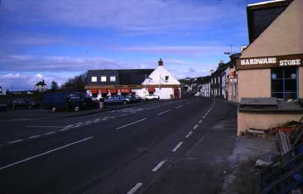
Gairloch is important as a service centre for the surrounding area. Strath Square (796773) has a hardware shop, post office, chip shop, two craft shops, hairdresser, restaurant and hotel. Nearby are two grocery shops, butcher and electrical shop with newsagent. An old folks home is also nearby. The number and order of services found in Gairloch are greater than would be expected for a village of its size. This is a reflection of its distance from other large settlements (the nearest are Ullapool and Dingwall, both 90 kilometres (56 miles) away).
[The businesses in Strath have changed in the intervening years but display the same basic pattern.]
| Next page | Top of page | Home page |