|
|
|
|
(849634, southeast)
This work was originally compiled in 1989 and is presented as produced at that time with additional notes, in square brackets, to bring the information up to date.
References to the Ordnance Survey Landranger series, sheet 19 may not be relevant if an edition published after 1974, the date of the previous major revision, is used. The material is presented unamended for use by schools in Highland which have copies of the southwest quadrant of the map issued at the time of compilation.
The grid reference of where the photograph was taken and the direction of view of each slide is given before its description.
The text is available on one page
Contents A. Physical landscape, natural
vegetation and land use Beinn Alligin / Beinn Dearg / Baosbheinn
and Beinn an Eoin / Loch Maree and Loch Ewe (1-4) The Fairy
Lochs / Gairloch beach / Beinn Airigh Charr / Inveran
(5-8) Gairloch
Pier / Fishing boats / Red Point salmon fishing
station Kerry
Fish Farm / Loch Garbhaig hydro scheme / Gairloch Quarry
(25-28)
| Next
page | Top
of page | Home
page |
|
|
|
|
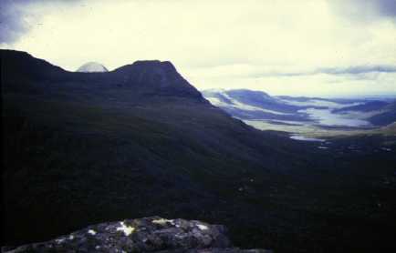
(849634, southeast)
This shows Beinn Alligin (8660) viewed from the northwest. It is made of Torridonian sandstone, a very old rock named after this mountain area, the Torridon Hills. The effects of glaciation can be clearly seen. The pyramidal peaks of Sgurr Mhor (865612), the highest top, and, to its left, one of the Horns of Alligin (873612) show the glacial erosion suffered by the hill. To the right, below Tom na Gruagaich (859601), is a good example of a corrie. The two main summits of Beinn Alligin, Sgurr Mhor and Tom na Gruagaich, are linked by a narrow ridge called an arête.
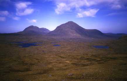
(915612, northwest)
This view looks west from Carn na Feola (915612) to the summit of Beinn Dearg (895607) on the far left. Behind can be seen Sgurr Mhor (865612) of Beinn Alligin which appeared in the last photograph. Here is another example of a corrie, this time with a lochan (hidden from view on the left) nestling below the rocky cliffs. A fine U-shaped valley (8862), its floor covered with glacial moraine, stretches away to the northwest and in the distance is L. a'Bhealaich (8664), a ribbon lake. The river (e.g. 8863) is far too small to have formed the valley without the help of a glacier;it is termed a misfit stream. This is further evidence of the glaciation of the area. The area is popular with tourists and much of the Torridon Hills are owned by the National Trust for Scotland (8860).
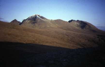
(935611, northwest)
Ice moving northward from the Torridon Hills gouged out the U-shaped valleys of Srath Lungard (9165) and those that contain L. na h-Oidhche (8965) and L. a'Bhealaich (8664). They radiate from where the ice built up. The three valleys can be picked out beside Baosbheinn (8765) on the left and Beinn an Eoin (9064) in the centre. These hills have been eroded by the passing ice and have a streamlined shape as a result. The area in the foreground of the photo is covered with ground moraine which has formed a hummocky landscape with many small lochans.
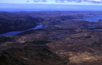
(925764, northwest)
A major ribbon lake is Loch Maree (8974, etc.). One important reason for its size is that it lies along a geological fault or line of weakness. A glacier has taken advantage of this weakness and formed a rock basin, now water filled, that extends well below sea-level. The water to the right is part of a sea loch called Loch Ewe. Beyond it can be seen a low rise; this scarp marks the line of the fault. In the middle distance on the left (8677), another important rock of the area can be seen. This is Lewisian Gneiss, a metamorphic rock. It often stands out from the sandstone as a more rugged landscape.