Climate

Home | Cabuynan | Map | Geography | Climate | Culture | Commerce | Language
Philippines | Leyte | Tacloban | Tanauan | Tolosa | San Pedro Bay | HammerArtz

Web Links: Today's Weather Tacloban | Tacloban Weather Forecast | Average Temperate and Rainfall Tacloban
CNN Weather Tacloban | QwikCast Tacloban Weather | AccuWeather | Tacloban Tide Charts | Solar Eclipses
Typhoon Watch | Pagasa |

The East coast of Leyte lies in the path of the north east trade winds ensuring a mild oceanic climate. There is no clearly defined wet or dry season. It can rain any time of the year but it is less likely to rain in the "hot" months of April to June and more likely to rain in the at the height of the monsoon season in 
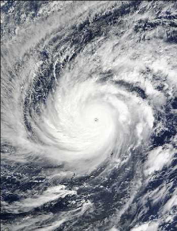
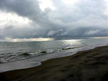
November, December and January.

When I asked one wise old "Lolo" in Cabuynan when is the wet season, his answer was "when it is raining". There is also said to be no bad weather, only "bed" weather!

The coolest time of the year is from November to March when the average maximum is in the high twenties (Celsius). The hottest time of the year is April to August when the average maximum is in the low thirties. Year round, average humidity is about 77%. It is a great climate if you don't mind the humidity!

Typhoons

Typhoons have a great influence on the climate and weather conditions of the Philippines. A great portion of the rainfall, humidity and cloudiness are due to the influence of typhoons. They generally originate in the region of the Marianas and Caroline Islands of the Pacific Ocean which have the same latitudinal location as Mindanao. Their movements follow a northwesterly direction, sparing Mindanao from being directly hit by majorty of the typhoons that cross the country.

Source: http://www.pagasa.dost.gov.ph/


Typhoon "Lupit" approaches the Philippines, November 2003. Source: http://earthobservatory.nasa.gov


Early morning rain, Bislig Beach


Sunrise over San Pedro Bay


Batten down the hatches a typhoon is coming

Climatological Information for Tacloban, Philippines

Location of weather station : 11.3 N, 125.0 E, altitude : 3 m

  Data
Period

Jan

Feb

Mar

Apr

May

Jun

Jul

Aug

Sep

Oct

Nov

Dec
Mean Maximum
Temperature
(deg. C)
1961-1990 28.7 29.0 29.9 30.9 31.4 31.3 31.1 31.4 31.3 31.0 30.1 29.3
Mean Temperature
(deg. C)
1961-1990 25.7 25.9 26.5 27.5 28.1 28.0 27.8 28.0 27.9 27.6 27.0 26.3
Mean Minimum
Temperature
(deg. C)
1961-1990 22.8 22.7 23.1 24.1 24.8 24.6 24.4 24.5 24.4 24.2 23.8 23.4
Rainfall Amount (mm) 1961-1990 281.7 204.1 139.6 118.9 142.4 160.8 167.0 135.5 161.5 197.2 279.0 305.3
Days with Rain 1961-1990 20.0 17.0 15.0 14.0 14.0 16.0 16.0 14.0 16.0 19.0 20.0 21.0

Source: Hong Kong Observatory

From Philippine Port Authority Webpage
http://www.ppa.com.ph

Climatological Conditions

Leyte is affected by the prevailing monsoons of the country, i.e., the SE and NE monsoons.  It has, therefore no pronounced wet and dry seasons.  The NE monsoons nevertheless has a greater effect, bringing slightly more rainfall during the months of November, December, January.  Compared with other regions of the country, Leyte has an even and moderate temperature with an average annual maximum of 30°C, minimum of 24°C and an average of 27.3°C.

Tidal/Range/Type

Tides do not follow the regular diurnal/semi-diurnal pattern.  They show irregularities which cannot be explained satisfactorily at present so that tide predictions are not considered suitable.

Tacloban Tide Charts


Sunshine on Bislig Beach


Blue sky and clouds, Limbuhan River

Hosted by www.Geocities.ws

1