|
|
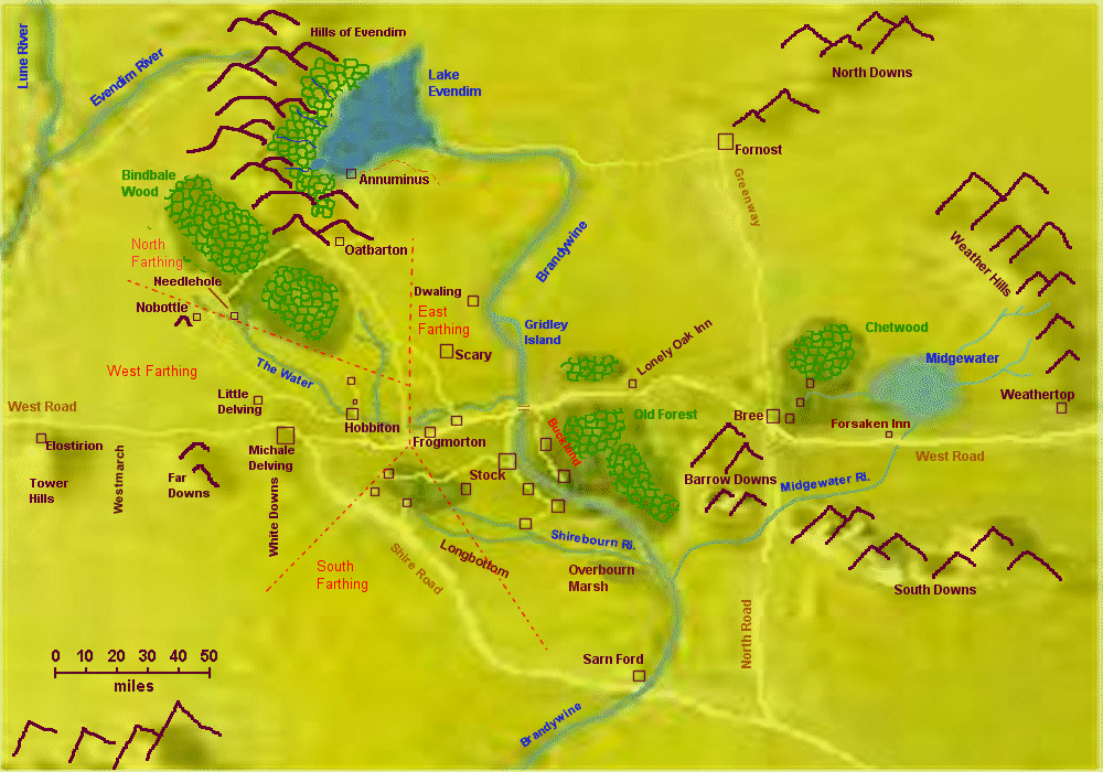
| Hills and Mountains Natural Environment of Eriador Political Divisions of The Shire Rivers Streams & other Water Bodies Towns & Places | |
Towns and Places | |
Bag End |
A substantial hobbit hole built by Bungo Baggins, III 2880, at the end of Bagshot Row in Hobbiton, The Shire. Later the Home of Bilbo and Frodo Baggins. Destroyed III 3029 (S.R. 1419) by Saruman during the scouring of the shire. Rebuilt by Frodo as a home for Samwise and Rose Gamgee. bagend |
Brandy Hall |
The ancient home of the Brandybucks, built by Gorhendad Oldbuck between the Brandywine River and the Old Forest. A substantial dwelling, containing many books of Eriador and the history of Rohan. It was the childhood home of Frodo Baggins before being adopted by Bilbo. |
Buckland |
Eastmarch. The narrow strip of land between the Old Forest and the Branduin, from the Brandywine Bridge 20 miles south to Haysend - added to the Shire III 2340 (S.R.740). It is separated from the Old Forest by the High-Hay, with only one opening at the Hedge-Gate. Its settlements are Bucklebury (Buck-Hill), Newbury, Standelf, Crickhollow, and Haysend. |
Bywater |
A small town on The Water, larger than and about 5 miles southwest of Hobbiton. The bridge of Bywater crosses The Water above a large pond on The Water where there is a large mill. |
Deephollow |
A small village in the East Farthing of The Shire (The Marish), on the west bank of the Brandywine River accross from Haysend. |
Dwaling |
A remote village in the northern Shire on the west bank of the
Brandywine River. Built on the ruins of an ancient village of Dimbar of the
Dúnedain of Arnor. The river road from Annúminus to Fornost
crossed the Branduin west of Dwaling and another road continued southward
on the west bank of the Branduin. Here, the army of Círdan's and
Eärnur crossed the river and defeated the Army of Angmar (III 1975). Fan Fiction - Hildigrim |
Frogmorton |
A town in East-Farthing near the middle of the Shire, 20 miles West of the Brandywine Bridge. Just south of The Water, and on the Great East Road. |
Haysend |
The southernmost village of Buckland (East March) of The Shire. On the east bank of the Brandywine River accross from Deephallow. |
Hobbiton |
A village of West-Farthing, the Shire, between The Hill and 4-5 miles West of Bywater. The home of Frodo and Bilbo Baggins, Sam Gamgee, and Ted Sandyman. The Ivy Bush Inn is about half way between Hobbiton and Bywater. |
Little Delving |
A minor road extreme northern West-Farthing of the Shire, North of the White Downs west of the road from Michel Delving to Nobottle. |
The Marish |
The agricultural region of East Farthing, the Shire, south of Stock between the Baranduin and the Green hills Country; and north of the Shirebourne. It is served by the Causeway and connected to Buckland by the Ferry. Its villages include Stock, Rushy, Deephallow, and Willowbottom. Woodhall is generally not considered part of the Marish. |
Michel Delving |
The largest village in the White Downs, West-Farthing, the Shire. On the Great East Road, local roads ran North to Little Delving, Tighfield and Gamwich. During the scouring of the Shire, used by Saruman the Lockholes (prison), for Fredegar Bolger, Lobelia and Will Whitfoot the Mayor. |
Needlehole |
A village of West-farthing, the Shire, 10 miles East of Nobottle and 5 miles North-West of Rushock Bog on the road from Hobbiton. |
Nobottle |
A very small village in the West-Farthing in the Shire on the road from Michel Delving and Oatbarton. Too small and and remote to bost an inn. In the moors west of Bindbale Wood. |
Oatbarton |
A village in North-Farthing at the extreme northern margin of the Shire in the North Moors at the southern edge of the Hills of Evendim. About 20 miles south of the ruins of Annúminus. |
Overhill |
A village just North of The Hill, West-Farthing, the Shire. Home of Sam`s uncle Halfred who worked for Mr. Buffin. |
Pincup |
A tiny, remote village in the Green-hill Country, South-Farthing, the Shire. Near the head of the River Shirebourn. |
Rushy |
A village in The Marish of East-Farthing, the Shire, about halfway between Deephallow and Stock a few miles west of the Brandywine River. |
Scary Quarry |
Nearby villages of Scary and Quarry, East-Farthing, The Shire, on the southern edge of the Hills of Scary. The quarry was probably the source of stone for the Stonebows Bridge over the Brandywine. Fredegar Bolger hid in Scarry with a band of rebels during the Scourind of the Shire, but he was captured and thrown in the lockholes of Michel Delving. |
Stock |
A town between the Yale and the Marish, East-Farthing, the Shire, about 5 miles South of the Brandywine Bridge. An important town on the "Causeway" just north of the Brandywine Ferry. |
Tookbank |
A village of Tookland, West Farthing, the Shire, 7 miles West of Tuckborough. On the Southwestern fringes of the forest of the Green-hill Country. |
Tuckburrow |
The largest town of Tookland, West Farthing, the Shire. On the Green-hill Country Tookborough was the home of the Thain in the Shire and the huge mansion built by Gerontius Took. The mansion included a library that included the oldest book in the Shire; Yellowskin, the Great Writ of Tuckborough. |
Waymeet |
Location of "The Dusty Way" a popular inn where the ancient road to Sarn Ford meets the Great East Road in West Farthing, the Shire. |
Whitefurrow |
A prosporous village of the Yale, East-Farthing, the Shire, about 15 miles west of the Bridge of Stonebows on the Great East Road. |
Willowbottom |
A village of East Farthing, The Shire at the junction of Thistle Brook and the River Shirebourne. At the southern end of the Causeway road, running south from the Great East Road, via Stock. |
Woodhall |
A village at the Northeastern edge of the Green Hill forest, East-Farthing, the Shire. Just south of the road from Stock to Tuckburrow. The hills of the forest to the West is where Frodo, Sam and Pippin spent the night with the Elves, before leaving the Shire. |
The Yale |
The agricultural region of East Farthing, the Shire, from Frogmorton east to the Brandywine Bridge; north almost to Gridley Island, and south to the Green hills Country and Stock. It is bisected by The Water and The Great East Road. Its primary villages are Frogmorton, Whitefurrows, and the houses at Brandywine Bridge. |
Political Divisions of The Shire | |
East Farthing |
The first-settled, most populous and most productive region of The Shire. The Hobbits following Marcho and Blanco Fallohide in III 1601 first settled in an abandoned village of Men (called "Bridgefields" by the Hobbits). This settlment was subject to flooding, and the Hobbits soon moved on. It was burried beneath many feet of mud during the flood of III 2912, and thereafter Stock and Frogmorton were the important towns of East Farthing. Other settlements include Brockenbores, Budgeford, Deephallow, Dwaling, Quarry, Rushey, Scary, Whitfurrows, Willowbottom and Woodhall. East Farthing includes the two most productive agricultural regions of The Shire - the Yale and the Marish - where most of its food is grown. It is crossed by The Shire's primary waterways: Stockbrook, the Shirebourn, Thistle Brook, and The Water. The Great East Road runs through it east-west, lesser roads are the Stock Road and the Causeway. East Farthing is the primary manufacturing area of The Shire, where most of its metal goods, furniture, and clothing are made. The villages Scary and Quarry provide the best stone the Shire has to offer for building. |
Eastmarch |
see Buckland |
North Farthing |
A thinly-settled and somewhat wild region of The Shire. Its economy is based on timber, wool, mutton, and dairy products, but the Greenfields area between The Water and Nubby Brook produces the finest "Noddytop" wheat in The Shire. North of the headwaters of The Water are Bindbale Wood and the North Moors. Its only settlements are Needlehole and Oatbarton. |
South Farthing |
The realm of the Tooks and an important agricultural area. The Tooks, dwelling mostly in Tuckborough, are lead by The Thain, who is also the military leader of The Shire. It includes the sparsely-forested western portion of the Green hill Country, and the rich farmland of Longbottom. Longbottom is the renown farmland west of the Shirebourn and east of the Shire Road where the very highest quality pipe weed is grown. Other crops of South Farthing include cotton, maize, sorghum and wheat. Its settlements include Hardbottle, Longbottom, Pincup, Sackville, Tookbank and Tuckborough. Sarn Ford is generally considered to be part of South Farthing, whenever it is considered part of The Shire. The South Farting is crossed by the Stock Road and the Shire Road from Waymeet to Sarn Ford. Its only river is the Shirebourn, which forms its eastern border. |
West Farthing |
The most recently-settled, but fastest-growing and therefore politically most important region of The Shire. The chief reason for its popularity is the ease with which sturdy Hobbit-holes can be dug in the chalk of the White Downs. The Mayor of Michel Delving is acknowledged to be the political leader of The Shire. He is elected every seven years during the Midsummer Free Fair. Its settlements include Bywater, Gamwich, Greenholm, The Hill, Hobbiton, Little Delving, Michel Delving, Nobottle, Overhill, Tightfield, Waymeet and Whitwell. The Water crosses its eastern end. Michel Delving is the western terminus of most traffic on the Great East Road; however, Elves and Dwarves continue on westward to Mithlond and the Blue Mountains. A smaller road leaves the Great Road northward through Bywater, Hobbiton and Nobottle, and eventually to Oatbarton in the North Farthing. The Hobbits of West Farthing are relatively well-off and of more cosmopolitan than those of the other Farthings. |
Westmarch |
The land beyond West Farthing, between Far Downs and the Tower Hills, added to The Shire by King Ellesar IV 32 (S.R.1452). It is the western terminus of the well-traveled portion of the Great East Road. It spans about 120 miles north-south and 50 miles east-west. In IV 35 (S.R.1455) Fastred and Elanor were made Wardens of Westmarch. They founded the village of Undertowers at the foot of the Tower Hills and there the raised many children, beginning with Elfstan. |
Rivers Streams and other Water Bodies | |
Brandywine Bridge |
Bridge of Stonebows. Completed by King Valandil at the same time as the Hoarwell Bridge (III 134), during the initial phase of construction of Arnor. Both structures are built uncannily well, and survived the flood of III 2912 without loosing a single stone. When the Hobbits were ceded The Shire by Argeleb II (III 1601), they agreed to maintain the bridge. In fact, their repairs are limited to maintain the approaches and cleaning manure from its surface. This "maintenance" is performed by a keeper, housed west of the bridge and paid by town of Stock. |
Gridley Island |
A large island (4 miles N-S by 1� miles E-W) in the River Baranduin, about 10 miles North of Bridge of Stonebows. The location of the ruins of a fortification of Arnor, abandoned ca. III 850. |
Overbourn Marshes |
The Overbourne Marshes occupy a low area fed by the Baranduin Shirebourn Rivers. East of South-Farthing in the Shire, south of the Marish. |
The Water |
Flowing from the North Moors of North Farthing about 50 miles southeast trough West Farthing and then East another 50 miles past Hobbiton and Bywater, where it is joined by a small stream from the North. From there it flow on to Budgeford, north of Whitefurrow, and the on to the Branduin 2 miles North of the Bridge. |
River Withywindle |
Flowing southwestward through the Old Forest from the eastern Old Forest to Baranduin in West. The waters are enchanged by the River-woman, mother of Goldberry by the Barrow-Downs. From the Barrow-Downs it descends a falls and passes the house of Tom Bombadil, and the ground of Old Man Willow. From there it turns southward for 5-30 miles to the River Baranduin just South of Buckland. |
River Shirebourn |
Flowing from the Green Hill Country of the Shire, South 10 miles, East 30 miles past Willowbottom and the mouth of Thistle Brook, and then 15 miles East to the Baranduin River. |
Sarn Ford |
The crossing of the Baranduin 70 miles South of the Old Forest and 50 miles southeast of the Shire along the road from Waymeet to Tharbad. The junction with the Greenway is about 70 miles from Sarn Ford. The village there has some some quays and landings, a few cabins and the inn of Old Moss. Established early in the Second Age as a settlement of Arnor on the ancient road from Annúminus and Tharbad. Sarn Ford was the location of the first battle in the defeat of Sauron's army, II 1700, by the forces of Númenor. |
Thistle Brook |
Flowing eastward from Woody End of the Green Hill Country of East Farthing, 30 miles South-East to Willowbottom where it joined the Shirebourne. |
Hills and MountainsThe Mountains of central Endor are produced by the Eriador Anticline, a broadly uplifted feature stretching over 300 miles from the Far Downs to the Trollshaws. The anticline is truncated by the Blue Mountian orogeny to the east and the Hithaeglir orogeny in the west (probable plate boundaries). The anticline was mildly compressed east-west during the Thangorodrim orogeny, which produced minor folding and faulting in the south, but strong compression (and high-grade metamorphism) in the northern Hills of Evendim and North Downs. The same event is associated with minor mafic volcanism in the North Downs, which extends southward to Bree. The sediments exposed in the Eriador Anticline are marine limestones, shales, and sandstones of Vardan age. Massive limestones are exposed in the eastern end of the anticline, and chalky limestones in the western end. Arkose sandstones, metamorphosed to quartzite, occur in the Hills of Scary and northward. Shales are exposed in the southern Green Hills. The Anticline is cut north-south by a series of streams which follow
structural lows created during the Thangorodrim-age folding and faulting. | |
Green Hill Country |
The most extensive (50 miles E-w x 15 miles N-S) hills in The Shire, spanning portions of West, South, and East Farthings. It is densly forested except for its western end. Three streams head in these hills: the Shirebourn, Thistle Brook and the Stockbrook. The Stock Road crosses the Green hill Country east-west, starting in Tuckborough. |
Pass of South Downs |
A deep gorge leading to a high pass over 5000 ft. elevation between the South Downs and Barrow Downs. Through it ran the "Greenway" of the North-South road from Fornost and Osgiliath. After the fall of Arnor, the most dangerous part of the journey, due to bandits. |
Weathertop |
Amun-Sûl. The great tower of Amun-Sûl was built by King Elendil (III 103) to hold one of the palantiri of Arnor. Elendil stood on Weathertop, watching and waiting for Gil-Galad to come out of the west in the days of the Last Alliance of Men and Elves. In III 1330 it was fortified by Argeleb I during the conflict between Arthedain and Rhudaur. In III 1409 Amon Sûl was destroyed by the army of Angmar. |
Natural Environment of EriadorThe environment of Middle-earth is similar to that of contemporary Western Europe. They bear obvious geographical similarities ( rover.wiesbaden.netsurf.de/~lalaith/Tolkien/), and the environment of Middle-earth ranges from glaciers and permafrost in the north (Fordwaith = Greenland) to hot deserts in the south (Harad = Near East). Snow is common in winter, as are spring floods. Droughts are not mentioned, nor is irrigation. The plant names mentioned by Tolkien all occur in Western European today: The crops are likewise typical of Western Europe: orivaine (pea Pisum sativum), kolosta (cucumber Cucumis sativus), pole (oats Avena sativa) corn (wheat Triticum; LotR, Treebeard), aipio (cherry Prunus sp.), marin (apple Malus sp.), kulmarin (Citrus sp.), l�ne (cotton Gossypium sp.) and pipe-weed (tobacco Nicotiana sp.). ( http://www.uib.no/People/hnohf/botany.htm). It seems safe to assume that Middle Earth enjoys a temperate, winter-wet climate. The growing season probably varies from 4 months (tobacco, cotton) in Gondor and Umbar to about 3 months in the Shire. The domesticated animals of Tolkien's writings are also characteristic of Northern Europe: chicken (Hobbit, ch. 1), geese, dogs (LotR, Strider), cats (LotR, Crossorads), pigs (LotR, Mount Doom), sheep, goats, cattle, horses, ( http://shirepost.com/RatesFees.html) The types of vegetation mentioned include forest, grassland (Hobbit; LotR, Many Partings), desert (LotR), Heath (and heather, Hobbit), Moor, Swamp, Marsh (Hobbit, LotR). Considering that fir, pine, oak and elm, and various other forest trees are named ( www.uib.no/People/hnohf/) it seems safe to assume that Tolkien envisioned a range of vegetation types similar to that of Western Europe. Two aspects of environmental change appear repeatedly in Tolkien's works. The first is deforestation, a theme associated with Treebeard (LotR), but one found throughout Tolkien's works. The vegetation patterns visible in Tolkien's maps are the result of millennia of forest-cutting by Men, particularly the Dúnedain. Treeless vegetation may be native in the frozen north and the desert south, but elsewhere forest vegetation is the norm. Why, then, are there grasslands in Rohan? A rainshadow cast by the White Mountains seems plausible, implying that the primary source of precipitation is from the south (Bay of Belfalas). However, what could be the source of moisture for Fanghorn, Lórien, and Mirkwood, which are farther north? They are on the east flank of the Misty Mountains, a loftier range than the White Mountains, and therefore a more effective rainshadow. The vegetation east of the forests - toward the Sea of Rhûn - is depicted as treeless, but a forest is shown on the northeastern shores of the Sea. Since storms are blocked to the West and South (and North), the moisture for Mirkwood and the other forests must be coming from the East. Perhaps "the East" has also been deforested, but how could there have been a forest there, in the first place, if there is no source of precipitation? And winds from the east are often noted in the Lord of the Rings. The moisture for Fanghorn, Lórien, and Mirkwood must come from the east. Tolkien never drew a map of the Endor east of the Sea of Rhûn, but beyond the sea of Rhûn was the Sea of Helcar, and beyond that the mountains of Orocarni. Perhaps the sea lay not far beyong those mountains. It may be that on the shores of that sea were Cuivi�nen, where the Elves first appeared, and Hild�rien, the first home of the Men. The vast forests west of the Misty Mountains imply that the ocean cannot be too far to the East, perhaps no farther than the distance from Lindon to the Misty Mountains. The proximity to the sea might also explain some geological features of Middle-earth www.tolkiensociety.com/1992/tcc_ab08.html. If the mountains of Mordor were formed when a tectonic plate was thrust westward (cf. India thrust northward) as it appears on Tolkien's maps, the eastern Ocean cannot be far off the map. The second aspect of environmental change is climatic. Throughout Tolkien's works the Valar, including Melkor and Sauron, cause storms of various types. For example, the Valar send lightning storms to Númenor as a warning, at the end of the Second Age. Even the Witch Lord of Angmar (Captain of the Ringwraiths) is said to cause frost and thaws, according to Snowmen of Forochel (LotR, Appendix A). If the weather can be changed, might also the climate? The cirques and u-shaped valleys that appear in the drawings of Middle-earth by Tolkein and other artists suggest a formerly-extensive glaciation. Climate change might also explain some of the events of the Second Age. At the end of the Third Age, Angmar, north of the Misty Mountians is too cold to support its large army by any form of local agriculture, and it had no other know source of income such as mining. Likewise, the area surrounding Annúminus and Fornost is steril moor at the end of the Third Age, but was likely productive when Elendil chose it as the location for his Empire. Perhaps northern Eriador was warm enough for widespread agriculture during the Third Age from the time of the founding of Arnor until the founding of Angmar (ca. III 1200-1300). | |
Bindbale Wood |
A forest mostly regrown after the downfall of Arnor, stretching from North Farthing in The Shire 80 miles northwestward along the west side of the Hills of Evendim to withn 20 miles of the River Luhn. |
Chetwood |
A spreading woodland north and east of Bree. Primarily filled with pine, birch and other second-growth trees, recovering from the extensive logging of the Dúnedain during the first half of the Second Age. The village of Archet is built among the trees of Chetwood near its southern edge. |
Dr�adan Forest |
The forest that surrounding the Eilenach beacon-hill in An�rien, in the White Mountains. It is so named for the remnant of the Dr�edain who live there. |
Eryn Vorn |
Black Woods. A remnant of the ancient forests of Endor, protected on a narrow cape in the Bay of Belfalas, just east of the mouth of the River Branduin. Like Fanghorn, it is made up of fir, birch, rowan and linden, but no Ents live there, although it is rumored that Entwives did, and may still. A few wandering tribes of the Gwathuirim live along its northern margins. |
Fangorn Forest |
A remnant of the old growth forests of Endor, set in the western foothills of the southern Misty Mountains. The forest trees include Ents still dwell in the Third Age and Treebeard is the first among them. |
Firien Wood |
The dark oak woodland that surrounds the beacon-hill of Halifirien, on the borders of An�rien and Rohan. Close by is Firienfeld, the green field, beneath the peaks of Snowbourn, Starkhorn and Irensaga, and then, beyond, Dunharrow. |
Golden Wood |
The forest of L�rien, referring to the golden Mallorn that grew in that land. In autumn their leaves fall not, but turn to gold, and not until the new leaves form they fall, and then the boughs are laden with yellow flowers above pillars of silver, for the bark of the trees is smooth and grey. (LotR, Lothlorien) |
Green Hills |
Second-growh forest of eastern Green Hills Country, comprised of a patchwork of pine, fir and alder; with birch and willow along the streams. And there are deep brakes of hazel, in one of which Frodo, Samwise and Pippin spent the night with Gildor Inglorion and other Elves, as they left The Shire. |
Lindon |
Ancient forest between the Blue Mountains and the Western sea. These are the wettest forests of Middle-earth, in fog and rain except for mid-summer. Fir, spruce, redwood, and alder grow there. |
Mirkwood |
Greenwood the Great The original name of the great forest that lay between the River Anduin and the River Running was Greenwood, but it became 'Mirkwood' (III 1050), filled with spiders and other evil creatures after Sauron (as the Necromancer) appeared in Dol Guldur in its southern regions. After the war of the Ring and destruction of Dol Guldur (III 3019) by Celeborn and Galadriel, it was renamed Eryn Lasgalen (Wood of Greenleaves) by Celeborn and Thranduil. |
Mistwoods |
The woodlands on the northeastern shore of the the Sea of Rhûn, stretching eastward nearly to the sea of Helcar. An open forest of oaks and hazel, but with elms, maples and hawthorns in the deepest hollows. (www.incanus.com/tolkien) |
North Moores |
Treeless heath south of the Hills of Evendim (Emyn Uial) and north of the Bindbale Wood. Covering part of North Farthing, The Sire. |
Old Forest |
An ancient forest from the gloomy shade before the First Age - part of the vast forest that once covered all of Eriador. At the time of the War of the Ring it spread 25 miles E-W and 40 miles N-S between Buckland of the Shire and the Barrow Downs. To the North ran the Great East Road and to the East the North-South road. The ridges of the Old Forest are covered with pines and firs, and oaks and ashes fill the valleys. Through it runs the River Withywindle and in it live Old Man Willow, and Tom Bombadil. |
Trollshaws |
Wooded hills of pine with beeches in the hollows, that lay to the west of Rivendell between the Hoarwell and Loudwater, so named for the trolls who live there. Three of of them; Tom, Bert and Bill, waylaid Bilbo and his companions during their journey to Erebor. Strider lead the four Hobbits through the Trollshaws after they were attacked by the Ringwraiths on Weathertop. |