READING TOWNSHIP, THEN AND
NOW:
(Large graphics, please be patient)
1875 map of Reading Township:
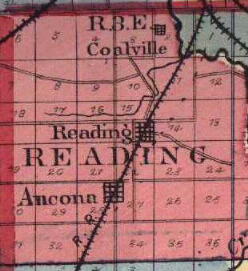
Graphic adapted from image found at:
www.rootsweb.com/%7Eusgenweb/maps/illinois/il1875/LIVINGST.JPG
Note that Moon Creek is incorrectly depicted
as running along the north side of Reading Road. The road that eventually
became Rt. 23 ends at Reading Road and there is no road where Rt. 17 runs
today. 17 was constructed by chain gangs in the 1920s or 1930s. It's also
interesting to note that in this map the railroad line runs straight, nowadays
it curves westward just south of Ancona. The remains of the railroad
right of way continuing southwest are plainly visible in the appropriate
Terraserver
images (Note: I have removed the Terraserver hyperlinks previously
in this text because they stopped working. Terraserver is a wonderful
resource, I hope this is temporary).
Out of curiosity I tried tracing the route
of the old railroad line on Terraserver as it went southwest of
Ancona. It's a straight shot through beautiful downtown Long Point
(named for the long point of timber along appropriately named Long Point
Creek). Just south of Long Point it curves slightly more west, then
continues through Dana, turns west through the center of Minonk, turns
back southwest again and continues through Benson. As the streets
of Benson are laid out parallel and perpendicular to the tracks instead
of N/S, I assume that Benson owes it's existence to the railroad line.
The line continues on through Roanoke and then curves into the town of
Eureka. I can't follow it beyond Eureka due to development and terrain.
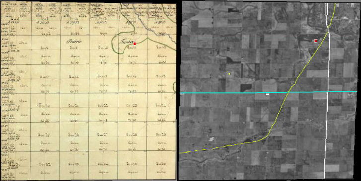
Graphic adapted from images found at
http://www.cyberdriveillinois.com/
and http://terraserver.microsoft.com
On the left is the 1830 plat from the
Illinois state archive database. On the right is a Terraserver
image shown at approximately the same scale. Moon Point Cemetery is the
red box in both pictures. To help orient the viewer in the satellite
picture, I've highlighted Ill. Rt. 23 in white and Ill. Rt. 17 in blue.
The Vermillion River is in the upper right-hand (NE) corner, the city of
Streator lies on the north side of the river. The Atchison, Topeka,
and Santa Fe Railroad tracks are highlighted in yellow. Between 1936
and 1971 thousands of people rode those very rails going between Chicago
and Los Angeles in Santa Fe's famous Super Chief. Amtrak's
Southwest
Chief took over the route in 1971. In the 1990s the Southwest Chief
was rerouted through Galesburg and no longer passes this way, although
this remains a very active freight line.
About a third of the timber that originally
comprised Moon's Point still exists. The portion to the north of
the section line between Sections 2 and 11 became the site of one the coal
mines that Coalville grew up around. It later became a gravel quarry and
then a dump. Today it's the state-of-the-art Streator
Area Landfill #3.
VILLAGE OF COALVILLE.
This is a little town, laid out by L. H. Mallery, October
6, 1865, near the coal beds, on Section 2. The town is occupied almost
wholly by parties interested in the mining of the coal, of which immense
quantities are taken out here. As much as 2,000 tons are mined per year;
and before the works at Streator were established, more than double this
amount was mined. The mines are owned by L. H. Mallery and others, who
allow them to be worked by other parties, who pay the proprietors a percentage
of the products. (From the The History of Livingston
County, 1878)
L.H. Mallery and his wife are buried in
Moon Point. Coalville today is little more than a handful of houses
along the road into Streator.
The tiny town of Reading lies next to
the tracks just north of Rt. 17. Older than Streator by almost 20 years,
at one time Reading was considered an up and coming little burg destined
for greatness as a major stop on the railroad line to Chicago. It
had a train station (named Moon), hotels, three general stores,
and several other businesses. It was a standing joke in the area
during the early part of the 20th century that one could take a train from
Streator to the moon.
In the latter half of the 1800s, Streator's
coal industry synergized with the railroads. Steam locomotives required
water and coal, Streator had both in abundance. Streator required
trains to ship it's coal to Chicago and other markets. The Great
Chicago Fire of 1871 also helped spur the development of Streator.
The rebuilding of the city after the fire created a tremendous demand for
the products of Streator's fledgling glass, tile, and brick industries.
Streator's sudden growth eclipsed Reading's development and lured away
potential business.
VILLAGE OF READING.
Excepting the county seat, this is the oldest
laid out town in the county, having been surveyed and platted previous
to 1851. In the year named, it was surveyed by Franklin Oliver for David
Boyle and Caleb Mathis, from the southeast quarter of Section 15. Scarcely
a prettier location for a town could be found in the whole county than
this. The ground is high and dry; and being on the bank of a fine little
stream of water, good drainage is rendered easy. The first house built
in the village was put up by L. S. Latham. Dr. Follet built an office near
the same time. 'The parties who laid out the town were also interested
in its business and its early improvement; and David Boyle, who was one
of the proprietors, and Jeremiah Mathis, brother of the other, built the
first store house. Mathis also built a hotel, and was the conductor of
the same. About this time the coal mines in this vicinity were being developed;
and people from all sections of the country, within fifty miles, came here
for coal. Being unable to make the trip in one day, and sometimes having
to await their turn, necessitated hotel accommodations for those who were
obliged to stop here over night. So extensive did this business become
in a few years that three hotels were at one time in successful operation.
Those times are all passed; and the weary and worn traveler, unless he
be so fortunate as to find a friendly villager who will take him in, must
pursue his tedious journey a few miles further. Dr. J. Hill came in soon
after the town was established, and built a residence and opened an office.
C. R. Kyser, who had been living in the township, came to the village and
built a blacksmith shop, and carried on the trade. Jacob Bussard,
in partnership with William B. Lyon, opened up a store a short time after.
They afterward dissolved, and each carried on the business independently,
thus making at one time three flourishing general stores. Prior to the
establishment of Reading, the people in all of this section of country
went to Lacon and Ottawa to do their trading; and, consequently, this enterprise,
in connection with the coal banks, drew a large amount of business to this
point. The town grew rapidly, and bid fair to be a place of importance;
but railroads, built soon after in other parts of the country, drew business
and capital away from the place, and Reading was left to languish. The
town is still a pleasant little place to live in, but the greatness that
was anticipated for it has all vanished. (From
The
History of Livingston County, 1878)
David Boyle, mentioned above, was Albert Moon's
father-in-law and it's likely that Reading's location arose from the proximity
to his daughter's family. Reading has dwindled in size even my own
lifetime. A large old house (Dr. Hill's??) that used to sit just
off the Reading Road was moved about a quarter mile south to face Rt. 17
and a jog that used to be in the Reading Road was straightened sometime
in the 1970s. Reading's long abandoned one room schoolhouse, which
was located near the bend in Moon Creek, was torn down about the same time.
The small white rectangle almost dead
center in the satellite picture is the white gravel parking lot of the
Sauder Equipment Company. The north/south line running next to Sauder
is the Ancona road. If you follow the road south and look very closely
you can find Ancona immediately north of where the road crosses the
railroad tracks (about where the tracks curve westward).
VILLAGE OF ANCONA.
The history of Ancona is quite similar to that of
Reading. With the change of dates and names, the remarks which apply to
the one, might with propriety be repeated. Ancona was, however, founded
on a different basis. The Great Air Line Railroad, from Fort Wayne to Council
Bluffs, had been projected, surveyed and partially graded through this
section, and there was not a doubt entertained that it would be completed.
Accordingly, in 1854, the town of Ancona was surveyed for Orson Shackleton
and Joseph Gumm. Depot grounds were set apart, and a street for a track
surveyed. True to expectation, the road was graded through the village,
and then Ancona real estate was held at high figures. Lots were sold
out rapidly, and buildings went up as if by magic. Stores
were opened and a hotel was built. Orson and Benjamin Shackleton built
the first house, a store, and occupied it with a stock of goods. The Shackletons
were form New York, and remained here until about eight years ago, when
they removed. L. B. Smith, who had been living in the township, and who
was formerly from Pennsylvania, built the first dwelling, which was the
second house in the place. He is still a resident, and occupies the same
old house. William Boatman, also a Pennsylvanian, soon after erected a
hotel, and as this was but a short distance from the coal banks it was
well patronized. Boatman afterward sold the hotel to Joel Willet, who had
been living in the township. Boatman still resides in the village. Willet
is dead, but the hotel is still kept open by members of the family.
Johnson Bradley came here in 1854, from Ohio,
and started a wagon shop, and still carries on trade at or near the old
stand. C. R. Kyser, who had been living in the village of Reading, this
year sold out his possessions there to Jacob Bussard, and came to Ancona
and opened a blacksmith shop. Joseph Gumm had also been in business in
Reading, and, seeing a bigger thing here,removed his store to this point.
Gumm and Kyser have both gone further west.
The enterprise that did most to actually develop
and give solidity to the town was the flour mill erected by Erastus Loomis,
who came here from Ohio. in 1857. At this time there was no such convenience
in this vicinity, or for miles west, and it naturally drew a large amount
of trade from the surrounding country. Wheat was then considered a good
crop, and a great deal of flour was made, not only for home use but for
the purpose of shipping abroad. After a while, the railroad seemed to be
a delusion; and, though it was a severe blow to the little village and
the neighborhood, they did not continue to mourn. A few years subsequently,
however, the mill was removed, and their hope of making this a town of
any great consequence went out. (From the The History
of Livingston County, 1878).
Caleb Mathis and Jacob Bussard, mentioned in
the above accounts, are buried in Moon Point. To those of us with
roots in Reading Township many of the surnames mentioned in these and other
early accounts of the area are familiar as the last names of family friends--
Mathis, Loomis, Coe, Defenbaugh, Bradley...
Aside from the grain elevator, Ancona's last
commercial enterprise was Gabe
Carpenter's general store, which stood on the NW corner of the intersection
of Wall St. and the Ancona Road. Although in my family we always
referred to the store as "Gade's", I've recently been informed that the
store was run by Gerald and Ida Carpenter and that Mr. Carpenter was called
"Gabe". The store resembled something out of an old western movie
both inside and out. Mr. Carpenter kept more than one local farm
family afloat during the Great Depression by extending credit when few
others were willing to. His store was also a hangout for the local
farmers, which tended to give it a bit of an unsavory reputation as far
as their wives were concerned-- If they were shooting the breeze at Gabe's
they weren't at home getting their chores done. Mr. Carpenter (a
kindly white-haired gentleman when I knew him in the 1950s) retired some
time around 1960 and the building torn down shortly afterwards.
About all that remains in Ancona today is the picturesque
Ancona
Church of Christ. In the 1980s Ancona's post office was (and
may still be) located in the garage of one it's residents.
These tiny towns may seem laughably quaint
as we whiz by them at 55 miles per hour, it's easy for those of us who
grew up in an internal combustion powered world to forget the realities
of life when horsepower was actually supplied by horses.
From our family's homestead west of Reading
we thought nothing of jumping in the car for the 5 mile trip to Steve's
Market in "Number 3" (South Streator) for a gallon of milk or loaf of bread,
an errand easily accomplished in less than a half hour.
With a horse, though, one doesn't just
climb on and start the ignition, it has to be saddled or hitched first.
If the animal is in its stall this might take 10 minutes or so, if it's
pastured it might take twice that long just to bring it up. In western
movies you see riders gallop seemingly for miles, in reality this would
kill the horse. It would be a little hard on the rider, too, riding
a galloping horse is more strenuous than it looks.
Travel by horseback is in practice little
faster than walking, slower if the horse is pulling a wagon, figure 3-4
miles per hour on good trails. That errand to Steve's Market would've
taken 3 hours round trip, possibly longer, by horse and buggy. Something
you'd have to plan your day and chores around.
When you get to your destination you
don't simply park a horse and shut it off, if the journey is of any appreciable
distance or duration the horse has to be rested and fed and watered.
Stagecoaches could travel 50 miles per day but they were so named because
they stopped every couple hours to recieve a fresh team and thus traveled
in stages of 10 miles or so. Horsedrawn travel was realistically
limited to roughly 25 miles per day under the best of conditions, if you
expected to sleep in your own bed you stayed within a 10 or 12 mile radius
of home.
It was of necessity that towns like Reading
and Ancona had stores, livery stables, eating establishments, hotels, churches...
they were vital centers of commerce and social interaction, at least as
important in their heyday as urban shopping malls are today.
Woodland School, on the south side of
Rt. 17 near the right hand edge of the satellite picture, was built in
the 1950s to replace the many one-room schoolhouses in the area.
The tiny square highlighted in yellow,
left of center and north of Rt. 17 marks the former site of the Distant
Early Warning ("DEW Line") training center. At the height of
the Cold War, the DEW line
was a string of radar stations placed across the Arctic Circle to watch
for incoming Soviet bombers and ICBMs. Satellites rendered it obsolete
by the end of the 1970s. The center closed circa 1980 and the land
sold back to the farmer. Many of the site's buildings and antennae
still remain but the landmark radar sphere was removed in the mid-1980s.
People from Streator call the intersection
of Rt. 23 and Rt. 17 Four Mile Corner because it's four miles south
of town. The people living in Reading township simply call it Four
Corners and presently the Four Corners Family Restaurant occupies the
SW corner of the intersection. To the author, though, Four Corners
will
always be the tiny Shell gas station/short order grill that formerly stood
on NE corner.
It appeared to have been built in the
1930s, probably about the same time Rt. 17 went through. In addition
to burgers and fried egg breakfasts they offered hand-scooped ice cream
cones, a messy and delicious treat on hot summer days and the subject of
much lobbying of adult drivers by their younger passengers.
It was a place where farmers gathered
for morning coffee and to discuss the issue-du-jour, be it the Gub'mint,
the antics of hippies, or the (rising) (falling) market price of corn...
On my last visit there, circa 1977, there was a sign behind the counter
reading "Don't complain about the farmer with your mouth full". That
local institution was lost in the late 1970s, torn down to accomodate
widening Rt. 23. The present restaurant went up shortly afterwards.
| As can clearly be seen, today's roads
largely follow the section lines first platted in the early 1800s
and the crop patterns in the fields outline the 160 acre quarter section
farms. The bend in the Vermillion River near the upper right corner is
very inaccurate in the 1830 plat yet other features of the river (including
an "S" curve not visible in this graphic) are meticulous. This at
first lead me to believe that the river's course had been modified.
Further examination shows that the river's course is depicted accurately
along the section lines where the original surveyor would've actually had
to travel, the portions away from the section lines would've been concealed
by timber and the plat probably represents the surveyor's best guess. |
|