|
Moon Point Origins: Surveying
the prairie
The origin of the
cemetery's name isn't as clearly evident today as it was in the 1800s.
Moon
obviously from Jacob Moon and his family, the first settlers in Reading
Township. But in order to get to the point (sorry), we'll
have to examine the area as it was when the Moons arrived:
The Land Ordinance
of 1785 established the rectangular grid system that, whether we're conscious
of it today or not, is still tattooed on our landscape. The
law required teams of surveyors to draw plats and empowered the federal
government to sell the surveyed lands to the public. At the time
selling land was one of the largest (if not the largest) source
of income for the federal governent.
Surveyors laid
out square townships, 6 miles on a side. These were broken
down into 36 one square mile (640 acre) sections. Sections
could be further broken down into 320 acre half sections, 160 acre quarter
sections... City dwellers may not recognize that the standard "8
to a mile" city block found in most cities comes from a city block being
a ten acre 64th section. If they overlaid a map of their city on
the original surveyor's plats, they'd probably find that the major streets
tend to run along the section lines, possibly modified somewhat by local
geographic or political features.
I can only imagine
the difficulties encountered by these surveyors as they plied their trade.
Using compass and Gunter's
chain (the optical surveyor's transit didn't come into use until around
1840) they laboriously made their way across the land 66 feet at a time.*
Away from their homes
and families for weeks and months at a time, without benefit of roads and
with only the supplies they could carry with them, they painstakingly measured
their way across rivers and streams, through dense forest, and across prairie
covered with grasses that could stand over 6 feet tall. They braved
hostile Indians, disease carrying insects, venomous snakes, not to mention
Illinois' brutal winters and blistering summers-- All for $2 per measured
mile. Yet despite the obstacles and the limitations of the tools,
the maps they made were surprisingly accurate. The survey of Reading Township
in Livingston county was completed by 1830:
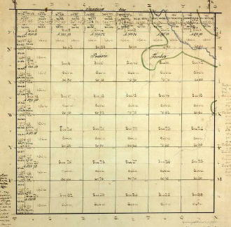 montaged from images found at
http://www.cyberdriveillinois.com/departments/archives/databases.html
|
*At first glance this 66' "chain" measurement
seems rather arbitrary, but it's the basic unit of all land measurement
in the United States. There are 80 chains to a mile and 10 square
chains in an acre. The archaic and peculiar 16.5' rod (sometimes
called a pole) is one fourth of a chain. Roadways were originally
to be 2 rods (33') wide, many city side streets and country roads still
are. |
|