| Frank & Lisa's Amazing Aotea/Kiwi/NZ Adventures |
| New Zealand South Island: Westland |
| on to Queenstown ...or |
| The next day we headed down the west coast of the South Island towards Greymouth. I'm not sure what I expected, but what we saw as not it! First we travelled through a mixture of familiar terrains, with one bit looking almost exactly like the scrub we saw along the south coast of Australia. (In retrospect this made sense since the two countries were once attached at about this spot...) Then it reverted back to all NZ unique flora. |
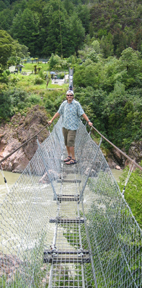
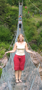
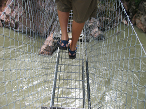
| Our first attraction of the day was Buller Gorge. They boast the longest swingbridge in New Zealand. So naturally, we paid our money and took our walk across it! :) We are both a bit height timid, but this bridge felt totally safe, even when you started bouncing and swinging with the motion of the people on it. There was a nice little walk over on the other side, too, where we could limber up a bit before the last leg of our trip to Nelson. (pics below) |
 |
 |
 |
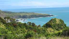
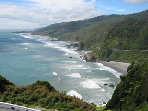
| When we actually hit the Coast Highway, my first impression was of a combination of the Great Ocean Road and the Captain Cook Highway! It was wrapped around the coast with rocky outcrops in the sea (pic right - go back and compare it to the |
 |
 |
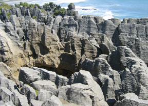
| The sun held on for the rest of the afternoon, which made our stop in Pukaiki a pretty one. We made our way to their most famous landmark, the pancake rocks, and enjoyed the stroll around thoroughly. The pancake rocks were formed when layers of soft limestone eroded away from between layers of more solid rock. The layering pattern supposedly look like pancake stacks (pic below left). During high tide there is a blowhole in the middle of one of the sets of formations that spits up seas spray betwen the stacks, but it was quiet while we were there. The walk around the area was beautiful, with other blowholes and ocean views to soak in along the way. |
 |
| For some reason we were booked in at a hotel in Greymouth for the night. All accounts said that Pukaiki was a great little resort town that put the lacklustre city of Greymouth to shame. And as we entered the town we knew that the tales were true! Greymouth is the city where the transAlpine train line from Christchurch ends, |
 |
| and that is about it. We took a very brief stoll along their unimpressive boardwalk, browsed a couple of jade shops, had a really good meal at the local pub, and looked forward to our trip to the glaciers the next day. On the way towards the Southern Alps & Franz Josef Galcier (for our afternoon heli-hike tour), we stopped in Hokitika, jade capital of Kiwiland! We checked out about 6 jade shops before picking our a few assorted gift items (and maybe a little something for ourselves)! :) I had seriously contemplated getting a set of jade dice for my parents to us for playing yahtzee, but I didn't think my mom would appreciate a set of $125 dice chipping the hell out of her twice refinished kitchen table (the plastic ones do damage enough)! Even in Hokitika the weather was cloudy, but by the time we headed into the mountains, it had turned foggy and rainy. As we had feared along teh way, our helicopter ride up to the top of the galcier for a hike through the ice caves was cancelled. And to top it off, all of the regular hikes that just went up from the terminal face were already full. The regular hiking trails at Franz Josef don't get you very close to the terminal face, and in that fog we would have been wasting our time. But Fox Glacier lay just around the corner and the trails take you much much closer. |
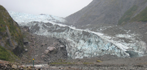 |
| Despite the half hour windy mountain drive in the rain, I convince Frank that we should check it out. And boy was it worth it! We hiked down the valley that the glacier's path had cut into the landscape (pic left) in the days when the glacier was still advancing, and got quite close to |
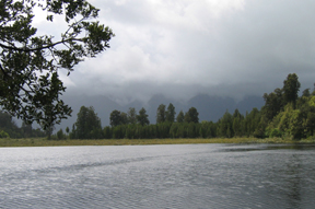
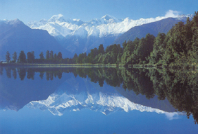
| our next visit! That night there wasn't much to do but dry our clothes and hang out indoors. The next day it was still foggy, but at least the rain was holding back. We stopped at Lake Matheson, one of NZs best known landmarks, for a futile hike to its famous viewpoint. The idea is to walk around to the opposite side of the lake, and on a clear day you can gt beautiful views of the Southern Alps reflected perfectly in the lake. This is the view boasted on New Zealand's best postcards! we took a picture from a lookout on this sid eof the lake that showed what each of the mountains was as a reference point and then set off. We got about 3/4 of the way around when the boardwalk became submerged under a good foot or so of water for as far as the eye could see until it turned a corner and ducked out of sight. We were not game to get even more soaked (we had an 8 hour drive ahead of us), so we headed back defeated. This is a comparison of our view of the Southrn Alps and what most people go to see (pics below). Another thing to put on our list of things to do the next time! And off we set for Queenstown... |
 |
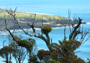
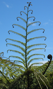
| soak in the surf, sun & sand, then we carried on to stop at a phenomenal lookout pointwhere Westland hit us with its own stunning and unique scenery (pics below). I also got to sneak in a picture of a silver fern frond (the symbol of NZ and their champion rugby team, the All Blacks (pic left). |
| GOR one). We stopped along the road and visited a coastal beach to |
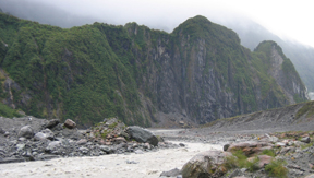 |
| the terminal face (pic below right). I hated to think about how great it (and our heli-hike) would have been on a clear, warm summer's day, but it just became one of those things on the list of things we had to do on |
 |
 |
| Northern Territory: Red Centre , 2 / Top End , 2 NSW & ACT: Hunter Valley / Sydney / Canberra , 2 Queensland Coast: 1 , 2 , 3 , 4 , 5 , 6 South Australia: Barossa Valley / Kangaroo Island / McLaren Vale & Coonawarra Victoria: Great Ocean Road , 2 , 3 / Melbourne New Zealand (North Island): Aukland / Rotorua / Tongariro / Wellington (South Island): Nelson / Westland / Queenstown / Milford / Dunedin / Mt Cook / Christchurch |