| New Zealand North Island: Tongariro Ntl Park |
| on to Wellington ...or |
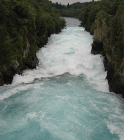
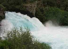
| The next morning we left Rotorua and headed towards Tongariro National Park, home of Mt. Doom. (Trivia fact: on a very clear day Mt. Doom can actually be seen from Hobbiton.) On the way we stopped at Huka Falls just outside of Lake Taupo. A bit of an anticlimax for a couple of Canadians, particularly one from the Niagara region! Huka Falls are the most powerful falls in New Zealand. We walked over the river on a footbridge and the rush of water was admittedly somehwat impressive given the river's actual size. (pic below left) While they do have much taller falls just about everywhere, these ones have the most water rushing over them... only to plummet a meager few meters to the river below! :) (pic below right) |
| Lake Taupo is supposedly a beautiful sight. The town sits on the north side of the lake and the marine parade is lined with cafes with huge patios so that toursits can sit and enjoy the views. However, the day had started out particularly foggy and cold, so we decided to just continue our drive around the lake on the way to our final destination. While neither Frank nor I is admittedly sure of the exact location anymore, we did pass a place boasting to be the rainbow torut fishing capial of the world that day. We passed similar signs before leaving the North Island claiming the titles of the trout fishing and brown trout fishing capitals. In short, a good place to come for freshwater fishing! My Dad would've been in heaven! We, however, had other plans... Our day of hiking through the mountains in Tongariro National Park didn't look promising. However, as advertised by the Department of Conservation (DOC) who put out the countries endless series of hiking trail maps, the weather in the area is extremely changeable. As we approached the park the clouds parted and dispersed, as if just for our arrival! We approached the park from the east and drove around the north side to get to Whakapapa Village to the west. We got our first glimpses of the peak of Mt. Ngauruhoe (alias Mt. Doom) as we passed a severely devastated logging area. Those who have seen LOTR will appreciate the irony... |
 |
 |
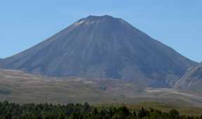 |
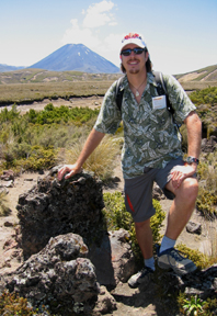
| Once we reached the west we were afforded spectacular views of both Mt. Ngauruhoe & Mt. Raupehu. Both are still active volcanoes. Mt. Ngauruhoe was chosen for the movie because of its perfectly symmetrical conic shape (pic left). It simply didn't require very much digital enhancement to turn it into a |
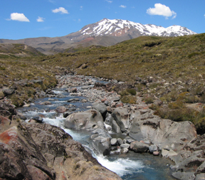
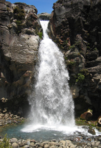
| suitably intimidating movie volcano! Mt. Raupehu actually has two or three craters (erruption points), so it lacks the shape you traditionally associate with volcanos. It is also the highest mountain peak in the entire country, so it is a popular ski area when it isn't spitting stuff! We left our bags at the hotel and set off on a hike. The most famous hike in the area is the Tongariro Crossing, however it takes 1-2 days to complete and we had an afternoon. And so began the list of the things we need to do onour next visit! :) This time we set off on a 3 hour loop hike to Taranaki Falls, between the two aforementioned mountains. We walked through a small beech forest and across a wide tussock plain before reaching our first real hill. There we found some remnant lava rocks spit from Mt. Doom itself (pic below left)! A while later we got to the most beautiful spot I could have imagined! We were smack between the two mountains with perfect views of both. Here I took my favourite picture of Raupehu (pic below right). Given that symmerty, Mt. Ngauruhoe looked remarkably similar to the first shot from this angle! :) Unfortunately, we didn't linger as long as we might |
| have, because our trail guide assured us that the views just beyond the falls on the other side were a favourite rest spot because of its unsupassed views! We couldn't believe that it was just going to keep getting better and the falls were just around the corner and down a hill, so off we went! After climbing down an obscenely steep set of stairs (some of the steps were higher than my waist and I actually injured my hip flexor and knee getting down them), we reached the main attraction - Taranaki Falls (pic below right). It was while we were sitting with our feet in the nice cold fresh spring water there that we realized we were doing the loop in the reverse direction to the trail guide! We had just been at the unsurpassed part, but there |
 |
 |
 |
| was no way I was going to try to get up those steps to see it again! I couldn't believe that the DOC actually recommended people walk in a direction that they had to go up those steps, let alone that all the othe people we passed were going to do just that! We definitely had an easier time of it going in our direction - a trend that we continued on later hikes by doing them backwards to what was recommended (Lisa's NZ trail tip)! The rest of the hike was incredibly picturesque as well. I thought that it looked exactly like I would expect Colarado to look like. A wide flat river running over a riverbed of pebbles with lots of twists and ares narrowing to the occasional falls before opening up again. Eventually we headed back across that flat plain (now even hotter and sunnier than before if that was possible) towards the start of the trail. From there we continued onto a second much shorter hike called the Ridge Walk. This one, as the name suggests, went pretty much straight up onto a ridge that had lovely views of Raupehu's snowcapped peak. In order to really get to the peak (or to the Crater Lake that sits in one of its volcanic mouths) you need proper winter gear, mountaineering equipment and good orienteering skills. The route is not marked, so you have to find it with map & compass in extremely changeable weather. We had been keen to try the Crater Lake walk up before finding that out, because we were assured that vulcanologists monitor any seismic activity vey closely and close the tracks if there is any sign of danger. Despite it all, our hotel sat quietly nestled between volcanic slopes. |
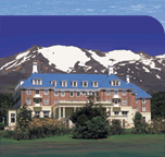 |
| It has been there long enough, though, so it must be safe...right? The Grand Chateau (brochure pic right) is the most famous hotel on the North Island and the second most famous hotel in NZ. It is reminiscent of the Chateau Laurier or Frontenac in atmosphere & style. It was incredibly luxurious in its day and exists as a classic testament to days gone by with nicely refurbished rooms and no air conditioning (our first nice hotel to lack it - welcome back to a country with |
| 4 real seasons and a culture of practical simplicity). It is second only to the Hermitage on the South Island, which has similarly unfortunate placement that I will discuss further when the time comes... That night we had a great dinner at the hotel at a remarkably reasonable price, rehydrated with a NZ beer or two, and went to bed exhausted from a full day of hiking in hot summer sun! |
| Frank & Lisa's Amazing Aotea/Kiwi/NZ Adventures |
| Northern Territory: Red Centre , 2 / Top End , 2 NSW & ACT: Hunter Valley / Sydney / Canberra , 2 Queensland Coast: 1 , 2 , 3 , 4 , 5 , 6 South Australia: Barossa Valley / Kangaroo Island / McLaren Vale & Coonawarra Victoria: Great Ocean Road , 2 , 3 / Melbourne New Zealand (North Island): Aukland / Rotorua / Tongariro / Wellington (South Island): Nelson / Westland / Queenstown / Milford / Dunedin / Mt Cook / Christchurch |