
deaddrift special report
VERDIGRE CREEK
THE DAMAGE DONE
NDEQ DOCUMENTS
AERIAL PHOTOGRAPHS
MAPS
WETLANDS INVENTORY MAP
OTHER DOCUMENTS
Letter from Cornhusker Fly Fishers to Nebraska Dept. of Environmental Quality. (disclaimer: deaddrift.com bears no responsibility for the accuracy of the claims made by the Cornhusker Fly Fishers)
![]()
November 27, 2000
Rob Schupbach
Cornhusker Fly Fishers
P. O. Box 22325
Lincoln, NE 68542
Email: [email protected]
Michael Linder, Director
Nebraska Department of Environmental Quality
1200 "N" ST.
Lincoln, NE 68508
Mr. Linder:
I am writing to express the very serious concerns of the Cornhusker Fly Fishers regarding the animal waste lagoon construction permit that has been issued by your department to Chad and Todd Te Velde for the NE 1/4, Sec 1, T27N, R6W, Antelope County, Nebraska.
In order to fully illustrate the seriousness of our concerns I have enclosed the following exhibits: (narrative of exhibits: ed)
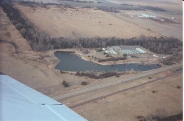
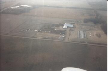
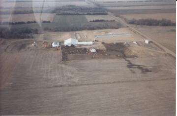
1. Two aerial photographs of liquid running down the TeVelde Dairy feed lot, taken in the late winter or early spring months of 2000, during the time of the #9 rainfall report. The grade of the TeVelde feed lot slopes from the northeast corner of the 1/4 section (elevation 1847) to the southwest (elevation 1800 feet) where the west branch of Verdigre Creek abuts the TeVelde property. Nebraska Highway 20 also forms a berm on the south border of the TeVelde tract that drains the TeVelde feedlot run off westerly into the East Branch of Verdigre Creek and then westerly into two wetland ponds labeled PABFX on the enclosed National Wetland Inventory Map, area of detail, for the Royal, Nebraska, Quadrangle.
2. An aerial photograph showing the relationship of the Te Velde feed lot to the berm created by Highway 20, with the drainage running into Verdigre Creek and Verdigre Creek running into the two wetland ponds indicated on the National Wetland Inventory map as "PABFX". The Cowardin et al Wetland Classification System used in NWI Maps Made Easy (exhibit 8) defines "PAB" as "pond with Floating or submerged vegetation, "F" as "surface water is present thought most of the growing season in most years, and X as "lies with in a basin or channel excavated by man."
3. National Wetlands Inventory Map, area of detail, United States Department of the Interior, for the Royal, Nebraska, Quadrangle.
4. The two ponds in the picture are the Melvin Bodenstead's property. Bodenstead's' s ponds are Federally designated wetlands, as PABFX.
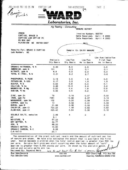
5. MANURE REPORT: "SAMPLE ID. DAIRY MANURE". Ward Laboratories, Inc. During the last week of March 2000, a local citizen observed liquid running down the TeVelde feed lot and into the ditch abutting Highway 20, the run off was creating a brown froth in the ditch before it ran into Verdigre creek. A sample of the water from the ditch that drains into Verdigre Creek, and then westerly into Bodenstead's two Federal wetland ponds, was taken and sent to Ward Laboratories. The lab report says "Sample ID: DAIRY MANURE". The TeVelde Dairy is the only dairy feed lot that abuts both the county road to the east and Highway 20 to the south (it is on the corner of the county road and Highway 20). . The TeVelde Dairy feed lot is the only feedlot that can run off into this area of road ditch. The TeVelde Dairy drains to the south into the Highway 20 road ditch, the Highway 20 road ditch then drains Westerly into Verdigre Creek and Verdigre Creek drains into Bodenstead's wetland ponds, designated as PABFX on the NWI Wetland Inventory Map.
6. Clearly the Waters of The United States of America, the Waters of the State of Nebraska and the Road Ditch of Nebraska Highway 20 are being degraded by the TeVelde Dairy manure runoff discharge from feedlot and stored solid animal waste.
7. An NDEQ memorandum Dated August 11, 1999 from NDEQ Employee Darwin Schulz P.E through NDEQ Employee Gary Buttemore P.E. to NDEQ Employee Renee Hancock. This memo contains the hand written note " we need to make it clear that the stockpiling of the solids must be in an area where runoff doesn't discharge into the waters of the state."
8. An index for the National Wetlands Inventory map, United States Department of the Interior, Royal Quadrangle. Titled " NWI MAPS MADE Easy
9. A rainfall and snow melt report for the months of January, February and March 2000. Compiled by the UNL High Planes Climate Center, Royal Nebraska Reporting Center.
This situation will continue in the future if animal waste is allowed to be stored in any form in the NE1/4, sec 1, T27n, R6W Antelope County. NE, because of the natural topography and drainage of the site.
The Te Velde site drains from the northeast (elevation 1847) to the southeast (elevation 1815 at the PABFX ponds). The stored solid waste and feedlot waste will drain into the road ditch, Verdigre Creek and the PABFX wetland ponds in any event.
Title 130 gives the Nebraska Department of Environmental Quality the authority to revoke a construction permit for and an animal waste lagoon for pollution the waters of the state of Nebraska. The natural topography and drainage of the NE 1/4, Sec 1, t27n, R6W, Antelope County, Nebraska are so flawed that pollution has occurred at the very beginning of the operation, when the TeVeldes are only milking 100 to 150 cows. Their application is for 1,000 animal units or 714 cows.
This evidence indicates that the site can handle no livestock.
We look forward to your speedy action, in writing, to this most serious matter in the next ten days.
Sincerely,
Rob Schupbach
For the Cornhusker Fly Fishers