Harwood Park Neighborhood
Improvement Association


Elkridge Historic Links & Photos
Prior to 1893, the neighborhood you see today was farmland. Thomas Cottingham is the first documented land owner in this area, later purchased by William Kyne.
The Kyne family farmed most of the 125 acres known as "Harwood Park." Although the farmland is gone, the Kyne's original farmhouse remains today, at the corner of Highland and Euclid Avenues, now owned by the Engelharts.
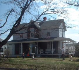
Farmhouse originally owned by the Kyne family
The land for the community was later purchased and developed by the Boston Land Improvement Company. On July 24, 1893, the new community of "Har-wood" was created. The first "planned" community development in Howard County.
This new development derived its name after two of the owners: William E. Harman and Charles Wood, of the Boston Land Improvement Company. Most likely the developers envisioned a community with homes located on lots for future development, placing restrictions on the types of businesses allowed within or around the community.
The idea of a "planned community" probably came about because of the close proximity of the Baltimore and Ohio Railroad (B&O) tracks. In 1935, train passengers were able to travel to and from Baltimore City, as well as Washington, D.C. Several B&O employees purchased lots to build homes in the new "Har-wood" development.
Railroad employees living in Har-wood were able to catch the train at the Har-wood stop (which used to be located at the end of Beechfield Avenue) at scheduled times and commute to their jobs. Other neighbors were also able to catch the train to shop for food at Lexington Market or pick up other supplies from businesses located in Baltimore City. The train was much quicker and easier than riding to Baltimore on a horse or carriage on dirt roads.
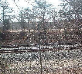
Site of Beechfield Ave. railroad stop
There were originally 1,259 lots planned for Har-wood. In order to protect property owners, there were restrictions placed on the use and building of the property. Wording from an 1894 deed issued to new property owners states, "Owners shall not permit to be erected on any part of the assigned ground, or any part thereof any tavern, saloon, tannery, slaughter-house, skin dressing, glue, soap, candle or starch manufacturing establishment, or any other building for offensive purpose or occupation."
There were also other restrictions including a 15-foot setback from the street for houses, as well as, proximity of stables, coops or other buildings. There was even a restriction on the minimum amount that must be spent to build a home in Har-wood; no less than $800.
Har-wood has two creeks running through the neighborhood, that flow into Deep Run. The creek over the Athol Avenue bridge is referenced as "Bascom Creek" by early railroad records. An 1860 Martenet's map lists this same creek as "Budd's Run."
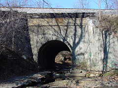
Bascom Creek Bridge
Picture and information courtesy of trainweb.org
Part of the occasional flooding in Har-wood is caused by the narrowness of an 1835 stone arched train bridge over Bascom Creek. When unusually high water flows down the creek, the structure limits the amount of water than can flow, and rushing water floods nearby residential properties. Two homes (on Harthorn and Glenmore Avenues) were removed in 2002 due to damage from the September 1999 flood in Harwood Park. These areas are considered "open space" and are owned and maintained by the Howard County Department of Recreation and Parks.
This train bridge is the "oldest surviving bridge on the Washington Branch" railroad, still being crossed over by CSX trains daily, although the structure is in serious need of restoration.
The other smaller creek currently has no official name, but flows under the Loudon Avenue bridge. The Harwood Park Neighborhood Improvement Association voted to petition the State of Maryland to call this stream, "Harwood Park Creek." Meanwhile, the stream remains unnamed, flowing into Deep Run. A Howard County capital project was recently completed to replace the existing culvert, widen the one-lane bridge and raise the roadway on Loudon Avenue.
Just a few feet from this bridge, there is another train bridge used daily that also assists the flooding of the road during a large rainfall.
After Hurricane Agnes in the 1970s came through the area and flooded out many homes and properties throughout Deep Run's tributaries, FEMA identified flood zone boundaries in Har-wood.
In the late 1990s, Howard County expanded the flood zone boundaries within Har-wood based on a computer model. Our neighbors protested the revision without actual field surveys and no prior notification to property owners of the boundary change. As a result, Howard County conducted a field survey in the summer of 2003 to determine that the homes identified to be in the revised flood zone have the potential to be flooded in a possible "100 year storm." We are still awaiting the results and evaluation of the results by Howard County Bureau of Environmental Services engineers.
In 1912, there were only about 15 homes built in Har-wood. In 1925, a public one-room school house was built to serve the Harwood/Hanover area. Eleven years later, the school was closed after the opening of a new school for the Elkridge area located off Old Washington Boulevard (the current site of the Norbel School). This one-room schoolhouse was converted into a private home, on the original site of the school just around the bend on Loudon Avenue.
Schoolhouse site
To learn about more recent history of Har-wood, Mr. Edison Hughes, Jr. was interviewed. He is one of the oldest residents still living in Harwood Park and can often be seen in the early hours of the day tending to his roses and his large vegetable garden. His family moved to Har-wood in 1925, when he was five years old.
Mr. Hughes' recalls that the Hughes family was the second owner of their house on Athol Avenue, with three lots purchased for $7,000, financed through the railroad. In the 1920's, there was a three-lot minimum for any property purchased in Har-wood. Sufficent land was needed for well water and septic systems to be separated. Some property owners still use well water to refresh their gardens, and some have chosen to remain on a septic system. There were only about five homes built on the street when they first moved to Har-wood.
He recalls that before most folks had automobiles, there were horse-drawn street vendors that would often frequent the dirt roads of the neighborhood, offering fresh bread, Esskay meats, or even fresh fish, caught by one of the neighbors out of nearby Bascom Creek.
On September 15, 1939, the Harwood Park United Methodist Church, located on the corner of Highland and Euclid Avenues, was built to serve the Hanover/Har-wood area. Many of the founding members of the church were within walking distance to the church. Since the church was a central point in the community, it is thought that the neighborhood became better known as "Harwood Park." Currently, this church serves as the main building for neighborhood activities. The Girl Scouts, the Harwood Park Neighborhood Improvement Association, and other organizations regularly use the church hall today.

Harwood Park United Methodist Church
During the depression (1930s), Harwood Park roads were not paved with asphalt, nor straight like you see them today. According to Howard County's records, the first public water main was installed in the neighborhood in the 1930's. After World War II, the Baltimore Gas and Electric Company installed poles and wiring which necessitated the straightening of many of the roads. Some neighbors can recall when Athol Avenue used to be a winding dirt road useable by horses and carriages, but tough on the early automobiles. Soon thereafter, automobiles replaced the train as the predominant mode of transportation.
The biggest influx of new homes to be built in Harwood Park came around the 1940s, after many soldiers returned from World War II. The train stop at Beechfield Ave. was eventually discontinued when ridership decreased and automobiles became more prevalent. The closest place to catch the train was to drive to the St. Denis or Relay stops.
In 1942, Mrs. Augusta Kossman, resident of the Harwood Park community formed a group called the "Minutewomen." With so many men away from home during World War II, this group of ladies met on a weekly basis to be prepared to protect and defend their homes in the event of an emergency. According to Leo Neault, his mother-in-law, Mrs. Kossman, was a skilled markswoman, who set up a practice range in the basement of her home on Athol Avenue. After receiving permission from the local police chief, neighborhood women began to meet on a weekly basis in her home for target practice. Prior to joining the Minutewomen, some women had no firearms experience at all.
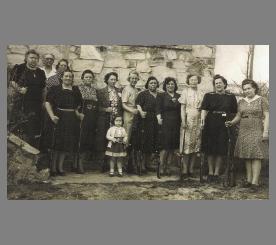
Harwood Park Minutewomen
Alleyways were a common feature of developments in the early 1900s. Today, many of the alleyways in Harwood Park remain throughout the older section of the neighborhood. In a letter dated May 12, 2003, by James Irvin, Director of the Howard County Department of Public Works, "the County claims no interest in these alleyways and we have never issued a legal opinion as to who owns these areas." In addition, there are two streets on the original plat records (i.e., Sycamore and Elm Avenues) referred to as "paper streets" that were never developed. In the same letter, it is stated "The County does not claim any interest in these paper streets. In the past, we have advised the public that they may have an interest in one-half of the streets, as provided by the law."
Harwood Park Alleyway
On June 24, 1950, Friendship Airport (today's BWI Airport) was dedicated and Harwood Park residents were now located in close proximity to air travel, just a few miles away from home. Little did the original homeowners know the amount of air traffic that would be flying over Harwood Park in the next few decades.
In 1961, the County Commissioners of Howard County passed legislation that accepted many Harwood Park roads into the county roads system. Thus began the introduction of public water and sewer into the neighborhood. During 2003, a water main rehabilitation program (Howard County Capital Project W-8255) was initiated to identify potential levels of pipe corrosion within the community, and its possible effect on existing water mains, as well as locate potential leaks in the distribution system. This project is in response to water quality complaints in the area.
The Harwood Neighborhood Park dates back to 1977 when the Elkridge Advisory Committee first requested the construction of a neighborhood park. The park was paid for with county capital project funds and a community development block grant from HUD. On September 15, 1982, Harwood Neighborhood Park was dedicated and open to the public. The original park included a full basketball court, tot lot and swings, similar to the park you see today. On September 6, 2003, the Harwood Park Neighborhood Improvement Association along with the Rotary Club of Elkridge adopted this park, holding its first volunteer clean up. With the help of over 30 volunteers, two new picnic tables and additional trash cans were installed, new flowers and bushes planted, mulch spread, weeds pulled, fallen trees and limbs removed, and part of the woods cleared of poision ivy and other invasive plants. Neighbors, along with the Rotary Club of Elkridge have committed to at least four clean ups a year, as well as monitoring the park for litter pickup and vandalism. On April 7, 2004, a new arboretum was dedicated in the park, with plaques donated by the Howard County Forest Conservancy Board. An identification plaque was located in front of 20 trees, and a new willow tree was planted in the rear of the property in commemoration of this event.

Harwood Neighborhood Park
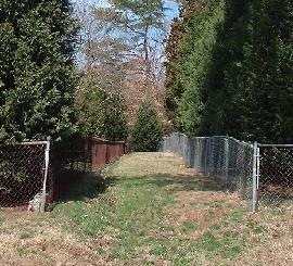
Howard County created a temporary exit road in Harwood Park for the use of residents living beyond the Bascom Creek bridge. In the event the bridge over Bascom Creek (on Athol Avenue) becomes flooded, residents can use a temporary road that was built on September 18, 2003 (in anticipation of Hurricane Isabel) on a county easement that connects Athol Avenue to Santa Barbara Court in the Route 100 Industrial Park. This temporary access road WILL ONLY BE OPENED in the event of an emergency. This road will be immediately closed once the regular access to the neighborhood is cleared. A locked chain gate is used at both Athol Avenue and Santa Barbara Court to block regular access to this road. The Public Works Department has suggested in the event of the Athol Avenue bridge flooding, to call 911 and speak to a supervisor who will be aware of this temporary access road. The Fire Department, Police Department and Bureau of Highways have been given keys to ensure that the barrier can be removed in a timely manner.
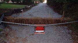
Entrance to emergency road
Harwood Park today is a melting pot of people. There are residents who have lived here since the early 1900s. There are neighbors who have lived here all their lives, within walking distance of their parents and siblings. There are new homeowners seeking a short work commute to Baltimore, Washington or Annapolis, or folks who want their children educated in one of the best school districts in this country. There are others who were attracted to the charm of an old established neighborhood, while others seek brand new homes built beyond the Bascom Creek bridge or in between lots of older homes.
Harwood Park is a great example of Elkridge's small town atmosphere. This is a community where neighbors walking the streets stop to say "hello" to each other, a place where the owners choose the colors of their houses, and the landscaping reflects the personality of the owners.
After just a few months of living in Harwood Park, the sound of the train occasionally humming along the tracks and its whistle, can be the comforting sounds of knowing that you are home.
Please e-mail [email protected] if you have more historical information to add to this history or photos of sections of Harwood Park in the 1900s.
Researched and written by Betsy McMillion, homeowner and Harwood Park resident.
Elkridge Historic Links
Elkridge History by Elkridge Real EstateElkridge Statistics Provided By Epodunk.com
Elkridge & Other Howard County Communities History Provided By HowardCounty.com
National Register of Historic Places - Elkridge & Howard County
Maryland State Archives
Elkridge/Relay Area Information & Photo
Early 1900 Thomas Viaduct Picture
Thomas Viaduct During the Civil War
Thomas Viaduct Aerial Pictures
Early 1900 Viaduct in Winter
1800 Viaduct Picture
1880 Viaduct Picture
1976 Levering Avenue With Viaduct
1886 Under the Viaduct Picture
1886 Viaduct Overlooking the Viaduct Hotel