Introduction
John Laurio Platt
John Askew visits Newcastle and Maitland in
the 1850s
Memories of Kenneth John Crebert
Exerpts from The Aldine Centennial History
of New South Wales, 1888.
Josiah Cocking's Poem Concerning the Unemployed
Camp, Platt's Estate
A Selection of images of Mayfield
Maps and Plans
Mrs Bertha Bathurst Downie of Mayfield
Interviewed by Judith Hughes
Ross Deamer on Waratah House
Ellen Lane's Recollections of Argyle House and
Shelley Beach
Helen Marshall's Heritage Walks
Vera Deacon's Memories of Mayfield West
and Platt's Channel
Whatever happened to Shelley Beach?
Introduction
The suburb of Mayfield was born from the township of Waratah, when John Scholey decided to sell a portion of his land under the name of his daughter May in 1881. According to T.A.Braye's "History of Waratah, N.S.W" the subdivision originally was bounded on the west by Kerr Street, on the north by Crebert Street, on the east by a line about five chains from Church Street southerly to the Maitland Road and along Maitland Road back to Kerr Street. This land grant was originally made on the Ist February 1854 to James Price of Buttai. From him it passed through two owners until being conveyed to John Scholey on 2nd April, 1881. John Scholey was a butcher who had rented the land as a slaughterhouse paddock, with a slaughterhouse and residence for slaughtermen. The paddock was heavily timbered with thick ti-tree bush growing along the Maitland Road. He had the land cleared, stumped and subdivided and called it Mayfield.
The land that Mayfield now rests upon formed part of a land grant of 2000 acres made to John Laurio Platt, who was one of the first free settlers to the region. He built his homestead on Ironbark Hill, which is now the Steel River site, formerly the location of the Murray-Dwyer Orphanage.
John Laurio Platt was born in 1782 in Nottingham England. In October of 1801 he joined the navy. In 1814 he retired and was appointed Harbour Master at Heligoland. On the 23rd December 1815 he married Rosanne Dutton and in 1821 embark ed on the ship "Providence" to Australia.
His letter of Introduction to the Governor, Sir Thomas Brisbane:
"This letter will be delivered to you by Mr John Platt who proceeds with his family to settle in New South Wales and proposes to erect sawmills and other machinery in the Colony. As Mr Platt has been for some years past employed under this Department on the Lakes in Canada, and as Harbour Master at Heligoland, and he has served not only with credit to himself but with advantage to the British Service, I have been directed by Lord Bathurst to introduce him more particularly to your notice and protection as having claims beyond those of an ordinary settler. Feb. 13th, 1821."
The Providence arrived January 7th 1822, Platt was granted 2000 acres in the County of Northumberland on August 21st 1822. By 1823 Platt was occupying his land and chosen Ironbark Hill. He was unable to get his sawmill working and so was forced to use it as a flour mill for the grinding of wheat. This was due to a lack of assigned millrights who knew what to do with a sawmill
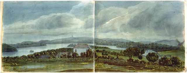
Painting by Sophia Campbell
of what could possibly be Platt's Farm circa 1829.
Note the mill at the extreme right, the Spit Island and Platt's Channel
behind the tallest building,
and behind that, a structure looking like Christ Church in the background.
Courtesy Images1 Database
National Library
In December 1831, tragedy struck when two of his young boys, while chasing bandicoots were consumed by a bush fire and killed. They were found by Constable Hewson and brought back to the homestead on Ironbark Hill. They were later buried at Christ Church Cathedral Cemetery. The family collapsed in on itself and by 1836 Platt and his wife were dead.
The remaining seven children were adopted by E.C.Close, a friend of Platt's and went to live in Morpeth. The eldest son remained on Ironbark Hill until the land was sold to the Australian Agricultural Company in 1839.
John Askew visits Newcastle and Maitland in the 1850s
Read an account of a visit to Newcastle and Maitland in the 1850s. John Askew describes what Mayfield would have looked like at this time, with a coach trip down the Maitland Road, as well as a stop over at Platt's Hill at a place he called "Ironbark Farm". The book by John Askew is entitled A voyage to Australia & New Zealand including a visit to Adelaide, Melbourne, Sydney, Hunter's River, Newcastle, Maitland and Auckland : with a summary of the progress and discoveries made in each colony from its founding to the present time / by a steerage passenger, John Askew Published London : Simpkin Marshall, 1857.The exerpt of Askew's trip to Newcastle begins on page 237 and ends on page 316, and is presented here, in full as a PDF document.
Memories of Kenneth John Crebert
Read exerpts from the memories of Kenneth John Crebert, who was born in 1854 and lived on the Folly, which later became a part of Mayfield. His father was Peter Crebert, the famous vine-dresser, who created the first wine in the Hunter Region. "Crebert Street" in Mayfield is named after him.
A Selection of Images of Mayfield
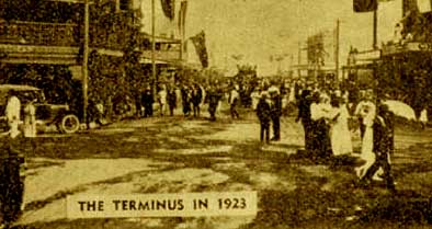
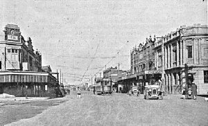
These images of the Terminus and Sussman Bike Race, as well as on the following pages of the Mayfield Website, are courtesy of Hunter Photobank Local Studies Section, Newcastle Region Public Library, the Picman Database, State Library of New South Wales and the Archives, Rare Books and Special Collections Unit of The University of Newcastle.
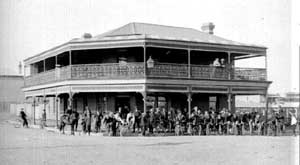
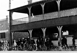
Terminus from 1923 to 1950
The 1927 Sussman Bike Race
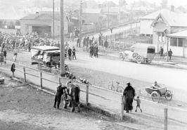
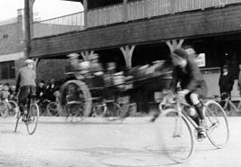
Ca. 1927 at the Sussman
Bike Race
Note the Mayfield Hotel in the background.
Maitland
Road with Platt's Mill c1840s - Land Titles Office
Registrar of land Titles Map
N21-1090 16th April 1852
Registrar of Land Titles Map N21-1090
(Attachment)
Australian Agricultural Map at Newcastle
NSW, 1854
North Waratah Map showing location
of Waratah House and the Mill Paddock, 1864.
Map showing Ash, Moscheto, Dempsey
and Spit Islands and much of Waratah and Mayfield areas, c1890s
Mayfield Street Directory 1925 -
from Wilson's Street Directory p.81
North West Waratah (Tarro Shire)
Street Directory 1930 showing Shell Beach Park and Platt's Channel
Mayfield, Municipality of Waratah Street
Directory 1/10/1930
Mayfield, Spit Island and Platt's
Channel pre 1950s
Three superimposed images showing location
of Spit and Platt's Channel on today's maps.
Mrs Bertha Bathurst Downie of Mayfield Interviewed by Judith Hughes
Mrs. Downie was born in Sydney in 1889, the seventh child of William and Isabella Ferrier of Scotland. Mrs. Downie attended Sydney Girls High School and became a schoolteacher, teaching at Erskineville and Minmi and later at Mayfield West and East Infants School. In 1911 Mrs. Downie moved to Mayfield and lived there for the remainder of her life. She conducted this interview with Judith Hughes on 21st June, 1988 and spoke about the impact of the BHP on the suburb of Mayfield between the years 1910 - 1920.
The
Aldine Centennial History of New South Wales
1888
This work was a type of "Who's Who" and contains some contemporary biographical information about some key figures in the history of Waratah and Mayfield during the period of the 1880s.
Josiah
Cocking's Poem Concerning the Unemployed Camp, Platt's Estate
The diaries and notebook papers of Mr Josiah Cocking were recently acquired by the Archives, Rare Books and Special Collections Unit of the University of Newcastle. Mr Cocking was a miner and part of the early socialist and free-thought movement of Newcastle. He lived for a time in Mayfield, and wrote much verse for the local papers of the time under such psuedonyms as "Dandelion" and "Capsicum". Here is one of his poems concerning military training that included a photograph of the unemployed camp at Platt's Estate.
This exerpt concerning the long lost "Waratah House" on the Hunter River, is from Ross M Deamer's Houses Erected on Original Land Grants in the Lower Hunter, Paterson and Williams River Valleys Between 1800 - 1850.
Ellen Lane's Recollections of Argyle House and Shelley Beach
Mrs Ellen Lane grew up on the land now occupied by the Steel River Site. It was originally the site of John Laurio Platt's farm, mill and house, and was later sold to the A.A. Company in 1839. The company later built their manager's residence, known as Argyle House on the land. It was later sold to the Catholic Church who turned it into the Murray-Dwyer Orphanage. Mrs Lane's story is entitled As It Was and was written for her family as a remebrance of her childhood years growing up in this area of Mayfield with the beautiful Shelley Beach and the fishing culture.
Helen Marshall's
Tour Of Mayfield
Mrs Helen Marshall was born in Mayfield in 1925 and has lived there for most of her life. In the Winter/Spring of 1995 she kindly agreed to conduct a set of heritage walking tours around Mayfield. These walks consisted of question and answer sessions concerning many of the historic houses and properties of the Mayfield suburb which were recorded and later transcribed. For a backgrounder on Mrs Marshall please click on her autobiographical recollections, otherwise, click below for transcriptions of the Heritage Walks 1 to 3.
Vera Deacon's Memories of Mayfield West and Platt's Channel
Vera Deacon lived on Mosquito (also known as Moscheto) and Dempsey Islands since the 1920s. During the Depression years the family left Dempsey Island and lived at Shortland, Platt's Estate and Mayfield, returning to Moscheto Island in 1939. Her father fished the river, and along with the other farmers, grew fruit, vegetables, corn and sorghum from the fertile soils of the Islands. Mosquito Island was famous, from early colonial times, for its oranges, grapes, bananas and milk. In their launch, the Lady May, they sailed the River, often doing the 'round trip' from Moscheto Island, taking in Platt's Channel to the South Arm, Hexham and Raymond Terrace, then home via the North Arm, round Walsh Island, into Moscheto Creek and home. They lived there until they moved in 1951, when BHP began filling in the Platt's Channel. She remembers her father showing her damaged fish and dying mangroves, exclaiming 'They're Killing the River', a river that had sustained her family during the Depression. Please read Mrs Deacon's memories of Mayfield West and Platt's Channel.
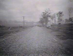
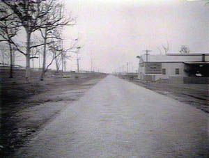
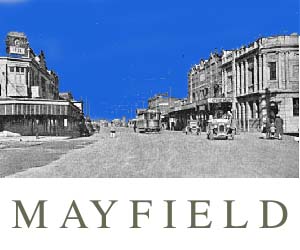
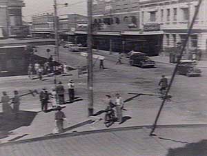
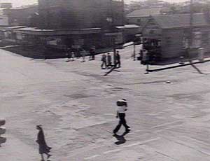
Two images, looking
west and east respectively, from what is today the Maud Street intersection.
Note the foundry on the left that is still there today.
Copyright 1995 - 2000 Gionni Di Gravio