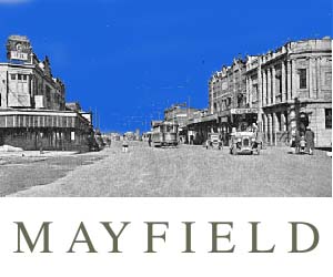
MEMORIES OF MAYFIELD WEST
AND PLATTS CHANNEL
by
Vera Deacon 1997
MEMORIES OF MAYFIELD WEST
AND PLATTS CHANNEL
by
Vera Deacon 1997
My father began our connection with the islands of the Hunter in 1922. My earliest memories are of Dempsey and Moscheto Islands in 1928. The River was like a second mother to our family and the daily rhythm of its life: winds, tides, gales, the industries, fishing, rowing up the south arm to the Black wharf at Ingall Street etched itself into our lives. The estuary and its islands from Raymond Terrace down to Walsh Island was our playground, our school, our work. We left Dempsey Island in 1932, living very briefly in camps at Shortland, a house on stilts at Platt’s Channel and then in two 'houses' in Mayfield West Unemployed camp. We weathered the depression and returned to Moscheto Island in 1939.
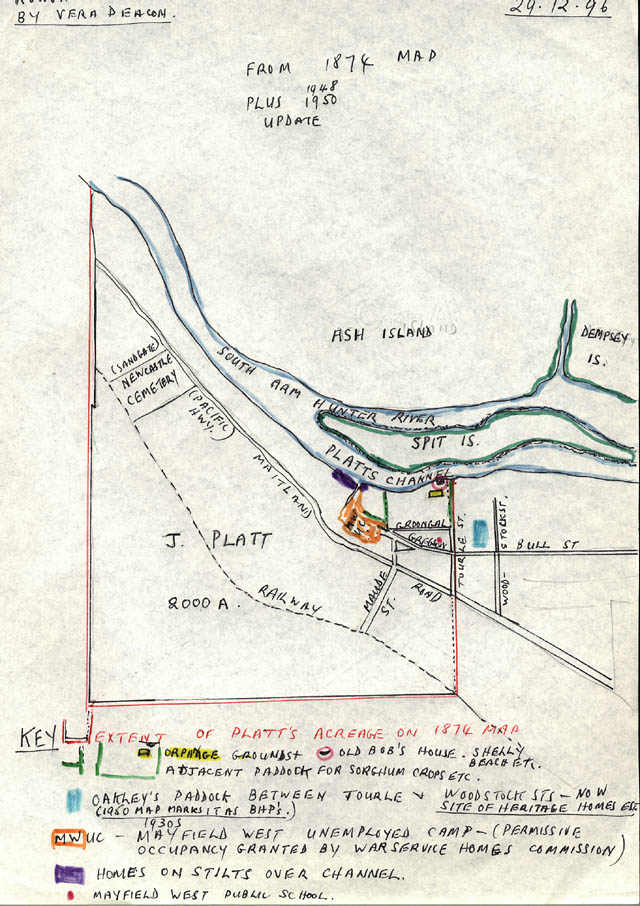
ROUGH SKETCH MAP KEY:
1. The RED BORDER defines the Platts estate area as shown on an 1874 map I have.
2. The green outline shows Old Bob's place on the river bank, just west of grassy Tourle Street.The Orphanage was high on its hill above. In the south-east corner of its grounds, not far from Groongal street was a mysterious dam overgrown with paspalum and other grasses. We avoided it. A little to the west of Old Bob's house, the dense growth of trees and mangroves gave way to a muddy bank with a few seedling mangroves. A long fence running from Gregson Avenue, which ended in those days at the wooden church, divided the acreage. On its western side grew corn or sorghum, I think it was part of the orphanage farm.
We ran along this fence to our tin toboggans' hidden in the bushes. Reckless, screaming with laughter we plunged down the hill into the mud or the river if the tide was in. The tides brought big sleepers. We nailed fruit cases to them and 'canoed' along. Capsizing we splashed and swam ignoring our father's warning about 'Noah's arks'. One day, in 1938, my black water dog, Flossie, swam behind as we 'canoed'. A shark rose, snapped its jaws and dragged her under. The water swirled with blood. White, fear-stricken we beached our craft and fell sick and sad on the grassy bank. I do not recall Shelly Beach park marked in any way at the end of Tourle Street. Fishermen like Dick and Alan Quayle, my father and others beached their boats. There, in early summer, 1938 Dad was restoring the LADY MAY, a launch he bought cheaply. My bother and I helped him. Dad, recovering from a lung complaint was hoping to lift the family out of the depression by taking line fisherman on parties to the Dead End on Rotten Row.
3. The AQUA BLUE area between Tourle and Woodstock streets we called Oakley's paddock. A 1950 map shows it as owned by BHP and is now developed as a small park and 'Heritage Housing'. I have a 1927 photo of my father, our home at the end of Woodstock street and the paddock.
4. The ORANGE area shows the extent of the Camp which had permissive occupancy from the War Service Homes Commission. From there we went to the Public School in Gregson Avenue where I finished sixth class in 1938. (If you want to read my story of this time, MAKING DO AND LASTING OUT it is in DEPRESSION DOWN UNDER, edited by Len Fox, republished twice by Hale and Iremonger).
5. The PURPLE area is the approximate position of the homes on stilts. I used to visit there, tracing a gully down to the bank, passing on the way a few gum trees and one loan 'egg and bacon' bush, (native dillwynia) a remnant of the once abundant bushland along the Hunter. I saw a reference to the water board promising water pipes to the area in a 1948 (I think) NH report.
BITS AND PIECES
Jim Latham, fisherman, told me fishing and prawning in the south arm up to Hexham/Raymond Terrace 'was my life'. Another man, Bill Artup had a shed somewhere on Platts Channel. In the 1920s he organised one shilling FUN DAYS: rowing, picnicking and fishing, I suppose. Probably similar to the AQUATICS and HEXHAM SAILING HANDICAP reported in the NH, 31 Oct. and 9 Nov. 1896. These, promoted by the Hexham Regatta Club, covered a course of 214 miles, beginning about 700 yards north of the Travellers’ Rest Hotel to a bouy moored near Ironbark Creek. Legendary scullers such as Harry and Tom Muncaster, George Towns, Peter Kemp and Chris Neilsen competed. Visitors from Newcastle, Wallsend, Dempsey, MOSQUITO, and Ash Islands assembled at the winning post and lined the river banks.
I note on an old map that the banks of Ash Island carried a generous 100 foot reservation for the aborigines to pursue their fishing!
Over from the camp the abattoir spread alongside Maitland road. I still recall its malodorus 'boiling down days' when the sickening tallow smell nauseated all. A stark, lonely hill on which a roadside hoarding flaunted a magnificent winged white horse, advertising ETHYL ... a kind of gasoline, I think.
Though poor we were rich in an imaginative freedom given to us by the river and its hills, gullies, fields. Not too far away, against the eastern sky, the industries, ground, smoked and steamed, chimneys stark, their pipes pouring oils, grease,' tars, poisons into the south channel. Trains hiccupped slag which infurated the river. An anger I still share.
Copyright 1997 Vera Deacon
Back to the Mayfield Website