
Waterbury, VT
Waterbury, VT | Barton, VT | Provincetown, MA | Sandwich, MA

OK... So these are some of the pictures taken off our digital camera. We'll be adding pictures taken on our other camera after we get them scanned. There were a lot more of these, and they'll fill in the gaps were we stopped using the digital because of the rain.
Our first four days were spent in Waterbury, Vermont, home of Ben and Jerry's Ice Cream.
 |
Day One: Climbing Mt. Mansfield, which is Vermont's highest peak. The hike we took was almost 5 miles, and 2700 feet of climbing! It was kind of rainy and cold most of the time we were in Vermont, which we loved because it kept a lot of the tourists off the mountains... |
 |
These two pictures are us during the early stages of our hike. Somewhere along here, we were passed by a couple hiking with their 7 month old kitten. And I do mean hiking. The kitten was climbing all by herself, scrambling up rocks that were taller than she was. We saw them again at the summit. They said the kitten made it all the way up by herself - pretty amazing! It was quite a scramble to get to the top though. There were places were we had to climb, hand over hand, to get up. Alyssa did great, blazing the path for us all the way to the top. |
 |
We liked this picture of the fall leaves on Mansfield. Little did we know, but the color would keep getting better each day we were there. We soon after had to put the digital camera away, as it got very rainy and windy. We have some great shots of the rest of our hike up Mt. Mansfield that we'll be adding later. |
 |
This picture was taken from the back yard of the first (and our favorite) bed & breakfast we stayed at, the Inn at Blush Hill. Our bedroom overlooked these woods, and the color in them was great. Ben and Jerry's is actually right behind those trees. |
 |
This is another picture out the back of the Inn. It was always extremely foggy in the morning. |
 |
On our second day, we hiked up Camel's Hump, Vermont's third highest summit. This hike was 5.4 miles, and rose 2400 feet. It rained on us most of the way (fortunately the trees kept most of the rain off us). However, much to our delight, it stopped almost the entire time we were above the tree line. |
 |
This is a view from the summit of Camel's Hump. We liked this summit better than Mansfield, because it was a much smaller so you could actually stand in one spot and turn 360 degrees and see all the leaves, valleys, and farms. |
 |
Another view from the summit of Camel's Peak. While we at the summit, clouds began to roll in. I liked this picture because it seems so sci-fi. I wish the weather had been a little better, because the pictures we got from this hike don't do the view justice. It was absolutely incredible! I think if it weren't so cold and windy, we could have spent all day up there! |
 |
For our third day, we drove up to the northwest corner of Vermont to do a 37 mile ride around the islands in Lake Champlain. The lake is the largest lake in the US after the Great Lakes, and home to "Champ," Vermont's version of the Loch Ness Monster (though we didn't get to see Champ while we were touring). This is a statue of Samuel De Champlain and an unnamed Indian. It is located on Isle La Motte, and marks the earliest European settlement in Vermont. Alyssa got so inspired, she decided to help Sam find his way. |
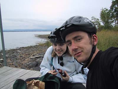 |
Midway through our tour of the islands, we stopped to have lunch on a public dock. We had crackers and some of the Cabot Cheese Factory's award winning chedder cheese. We got it the day before while we were doing the tourist thing in town. We also stopped by the Cold Hollow Cider Mill, and one of Vermont's handfull of wineries. They don't make wine with grapes in Vermont. We sampled an apple-raspberry wine, but they also made blueberry, rhubarb, and various other wines. I thought it tasted more like sparkling fruit juice than wine, but good just the same. In case you're wondering, its a tradition of ours to take a self-portrait by blindly shooting a picture at our heads whenever we're travelling. |
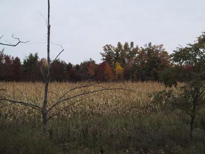 |
On the second half of our ride, we passed a corn field surrounded by woods. I liked this shot because of how the color of the dried up stalks goes with that spot of trees (it's a much better picture at full-size). All along the ride, we would pass sections of trees that had red, orange, and yellow together. Riding behind Alyssa, I stopped several times to take pictures without her knowing. One time, she made it all the way over the next hill before realizing she lost me. Not sure where she thought I went though, as we were the only ones around probably for miles :-) |
Waterbury, VT | Barton, VT | Provincetown, MA | Sandwich, MA