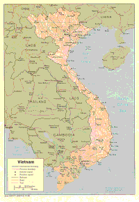
| Viet Nam is a country in the former French Indochina. Viet Nam is an
elongated strip of land along
the Indochina peninsula. To the east is the South China Sea and the Bay of
Tonkin is to the south.
To the west lies the countries Laos and Cambodia. To the north is the People?s
Republic of China.
Viet Nam has an area of 130 654 square miles. The length from the north to
the south is
approximately 1000 miles. Viet Nam is only 35 miles wide at Viet Nams' narrowest
point . The
widest Viet Nam becomes is 300 miles in the north. The majority of Viet Nam
is on the highlands'
of the Annamite Chain. This is the mountain range that creates the backbone
of the Peninsula. At
some place the highlands come into direct contact with the ocean. The result
of this is stunning
drops, at heights up to 8000 feet. In the north the Annamite Chain merge
with high plateaus that
continue into Laos and China. To the south the highlands evolve into the
Moi Plateaus. They in turn
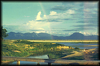
descend into the Mekong delta. The only significant river in the south is
the Mekong river, which
flows from China into Laos. Then, from Laos the Mekong travels through Cambodia
into Viet
Nam. It created the Mekong delta and continues to extend it. There are many
canals built their for
drainage, irrigation and transportation. The main river in the north is the
Song Roi, known as the
Red River in English. It Flows from Southern China into Viet Nam. It has
created the 6000 square
mile Tonkin Lowland. For over 2000 years there have been canals, irrigation
and dikes built on the
Lowland. These two lowlands are some of the best rice fields in the world. |