![]() Johor
Johor
![]() Malacca
Malacca
![]() Negeri Sembilan
Negeri Sembilan
![]() Selangor
Selangor
![]() Perak
Perak
![]() Kedah
Kedah
![]() Perlis
Perlis
![]() Pahang
Pahang
![]() Terengganu
Terengganu
![]() Kelantan
Kelantan
![]() Penang
Penang
![]() Sabah
Sabah
![]() Sarawak
Sarawak
![]() Kuala Lumpur
Kuala Lumpur
![]() Labuan
Labuan
![]() Putrajaya
Putrajaya

Sabah, state of Malaysia, which, together with the state of Sarawak and the Federal Territory of Labuan, makes up East Malaysia.
 Prior to 1963, Sabah
was the British Crown Colony of North Borneo. Occupying the
northernmost part of the island of Borneo, it is bounded on the
northwest and north by the South China Sea, on the northeast by
the Sulu Sea, on the southeast by the Celebes Sea, on the south
by Borneo (Kalimantan), and on the west by Sarawak. Its total
area, including the island of Labuan (a federal territory), is
about 73,620 sq km (28,425 sq mi), with a coastline of about 1450
km (900 mi).
Prior to 1963, Sabah
was the British Crown Colony of North Borneo. Occupying the
northernmost part of the island of Borneo, it is bounded on the
northwest and north by the South China Sea, on the northeast by
the Sulu Sea, on the southeast by the Celebes Sea, on the south
by Borneo (Kalimantan), and on the west by Sarawak. Its total
area, including the island of Labuan (a federal territory), is
about 73,620 sq km (28,425 sq mi), with a coastline of about 1450
km (900 mi).
Sabah is extremely mountainous; the only lowlands of importance are confined to the coastal region. A number of broad upland valleys traverse the interior. The highest peaks are found in the western part of the state; Mount Kinabalu (4101m/13,455 ft) is the highest summit on the island.
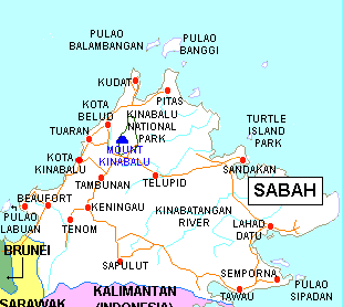
The incredibly rich biodiversity on Mt Kinabalu. Both the coastal belt and the mountain slopes are heavily forested. Streams are numerous and because of the rugged terrain are generally swift and interrupted by rapids. The Kinabatangan River is navigable by light-draft vessels for about 193 km (about 120 mi) inland from the Sulu Sea. The Labuk and Padas rivers are also important waterways. The coastline is indented by several large bays and natural harbors. Tropical climatic conditions prevail throughout most of Sabah.
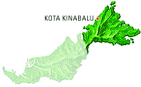
Kota Kinabalu, formerly Jesselton, the capital, had a population of 208,484 in 1991. Other important communities include Tawau (244,765) and Sandakan (223,432). The total population (1990) of 1,736,902 is composed of indigenous peoples and Chinese, as well as Malays, Eurasians, Europeans, and others. The main ethnic groups are Dayak peoples and include the Dunsun, Bahau, and Brunei (agricultural and fishing groups), Murut (hill dwellers), Suluk (mostly seafaring people), and the largest group, the Kadayan (primarily agricultural people).
Kota Kinabalu, city in eastern Malaysia, on the South China Sea, capital of Sabah state. Kota Kinabalu, known as Jesselton until 1968, is the commercial and administrative center of the region. The city lies between rainforest, the beautiful Crocker Range, and the coastline and coral reefs of the Tunku Abdul Rahman National Park.
Kota Kinabalu has had a dramatic history. It was sacked so frequently by 19th-century pirates that it was nicknamed "Api! Api!" by residents, meaning "Fire! Fire!" The town was relocated in 1899, destroyed by bombing in World War II (1939-1945), and rebuilt in 1946 as the capital of British North Borneo. Kota Kinabalu contains the Sabah museum of ethnology and the impressive State Mosque (built in 1977), designed by Italian architects.
The forests yield considerable timber, rubber, rattan, and other products. Extensive mineral deposits exist, including tin, antimony, diamonds, iron, and sulfur, but exploitation is hampered by poor transportation. There is some industry, manufacturing furniture, rubber, and plastics. Agriculture, forestry, and fishing are the leading industries. Rubber, timber, hemp, dried and salted fish, tobacco, and copra are the main exports.Tourism plays an increasing role in the economy, and there is an international airport.
Executive authority is vested in the head of state (called the Yang di-Pertua Negeri), who is advised by a state cabinet. The legislative assembly consists of 48 elected members and not more than 6 nominated members.
The region came under British control in 1877 when a British trading syndicate, later called the British North Borneo (Chartered) Company, obtained concessions from the sultans of Brunei and Sulu and other rulers in the region. The British North Borneo Company, under a royal charter granted in 1881, undertook the administration of the region.
In 1888 North Borneo was made a British protectorate, but the company retained its administrative powers until 1946, when British North Borneo was proclaimed a Crown Colony. During World War II (1939-1945) the region was occupied by Japanese forces. When the Federation of Malaysia came into existence on September 16, 1963, British North Borneo, renamed Sabah, became a member state.
![]() States
States
![]() Tourism
Tourism
![]() National Symbols
National Symbols
![]() History
History
![]() Geography
Geography
![]() Flora & Fauna
Flora & Fauna
![]() Economy
Economy
![]() Culture
Culture
![]() Festivals
Festivals
![]() Transportation
Transportation
![]() Accommodation
Accommodation
![]() Foreign Exchange
Foreign Exchange
![]() Food
Food
![]() Fruits
Fruits