|
Learning Center on Caribbean Weather and Climate |
Weather Radar in the English Speaking Caribbean |
|
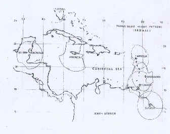
Back to Weather radars by Mrs. Margaret Pestaina-Jeffers, Meteorologist at the Caribbean Institute for Meteorology and Hydrology (CIMH). (The article was originally published in "The Advisory", The 35th Anniversary Edition of the CIMH, 2002.) Over thirty years ago a state-of-the art weather surveillance radar was installed at the Caribbean Meteorological Institute (CMI) at Husbands, St. James, Barbados. The radar antenna, perched atop a refurbished historic sugar mill wall at the entrance to the Institute, has become a landmark. This was one of six identical systems installed in the region, the others being located in Antigua, Belize, Guyana, Jamaica and Tobago. As the map below shows, this network provided reasonable radar coverage of precipitating weather systems passing through the Caribbean.
Radar beam pattern of the CMI affiliated radar network installed in the 1970s. Since installation of the radars in 1970, several radar meteorology courses at various levels have been conducted at the Institute. These provide weather radar users with the necessary skills to understand and interpret the radar imagery. CMI also provided maintenance and repair services to the other radar sites and maintained a stock of spare parts for sale to the meteorological services which operated the weather radars. The latter service was extremely useful since obtaining spare parts from Japan could take up to six months. In addition to the training and repair/maintenance services, during the hurricane season the radar operators at the Institute (even now, provided the radar is functioning) conduct radar observations. During periods of severe weather, at any time of the year, observations are taken, when requested, and forwarded to the meteorological office at the Grantley Adams International Airport. This provides vital information on the location, intensity, movement and development of approaching systems for use by the forecasters. The CMI affiliated radars are not the only weather radars located in the Caribbean region. Weather radars are located at other sites including Martinique, Guadeloupe, Puerto Rico, Dominican Republic, Netherlands Antilles and Cuba. The word ‘radar’ is an acronym of the phrase ‘RAdio Detection And Ranging’ and reflects the basic functions of weather radars which are detection of precipitation and determination of their range or distance from the radar. When an area of weather containing precipitation occurs, weather radar provides the best means of observing the area of precipitation. If there is a limitation, it is that of range, because radar allows observation to a range of about 400 km only. These older weather radars are analogue systems which, apart from giving information on location and speed and direction of travel of the precipitation echo as a whole, can also provide limited information on the relative intensity of precipitation within the area of weather. Such information is used to determine possible areas of flooding and to determine areas of greatest precipitation gradients, the latter being most useful for pilots flying Caribbean routes. This information is achieved either through use of a contour technique called ‘grey scale’ which uses different shades of grey to represent different intensities of precipitation or the ‘stepped attenuator’ which allows display of precipitation echoes of rainfall intensities above certain pre-determined levels. With the passage of time these techniques have become obsolete and one is now familiar with the colour presentations of most weather stations, the different colours representing different intensities of precipitation. Such displays are possible from digital weather radars which, with computers and the appropriate software, allow in addition, a greater variety of products to be produced for observation and analysis. Our older weather radars are not digital but analogue systems. Probably one of the most notable advances in the field of weather radar was the introduction of Doppler radar. Doppler radars, in addition to providing information on location, movement, intensity and development of precipitation, allow measurement of the speed and direction of the precipitation particles within the echo so that other information, for example, regions of updraft and downdraft, can be identified. Such radars are specifically designed and make use of the Doppler Effect from which they derive their name of ‘Doppler Radars’. Our older weather radars are not Doppler radar.
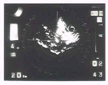
Hurricane David, August 1978, as seen by Barbados Weather Radar. TRADITIONAL – can give information on movement of entire precipitation area. Thirty years is a long time in the life of a weather radar! Like old motorcars, replacement parts have become at best difficult and in most cases impossible to obtain. To date only three of the original six radars are still standing. Those of Antigua, Guyana and Jamaica have passed on providing, in some cases, parts which have been used to keep the remaining ones located in Barbados, Belize and Tobago functioning sometimes.
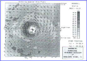
Time composite of the radar reflectivity and the airborne Doppler-derived winds at 6.5-km altitude in Hurricane Gloria at 0014-013 UTC September 1985. From 'Radar In Meteorology', David Atlas, Editor. AMS 1990. NEW – can give information on movement of particles within the precipitation area. The time has long passed for replacement and upgrade of weather radars in our Caribbean area. These are needed to provide vital information on areas of severe weather as may occur in tropical waves and the Inter Tropical Convergence Zone and to locate and monitor the movement and development of hurricanes within the Caribbean area. It is therefore hoped that the Caribbean Meteorological Organisation / European Union Project in the planning stage, to provide four new Doppler radars, will quickly come on stream. An important aspect of this project is the production of composite radar pictures which will show radar measurements taken by different radars at the same time, together in a single display. This will be available to the meteorological services and will provide useful additional information for weather forecasting and aviation purposes. Back to top of this page |