|
|
|||||||||||||||
|
|||||||||||||||
|
|||||||||||||||
|
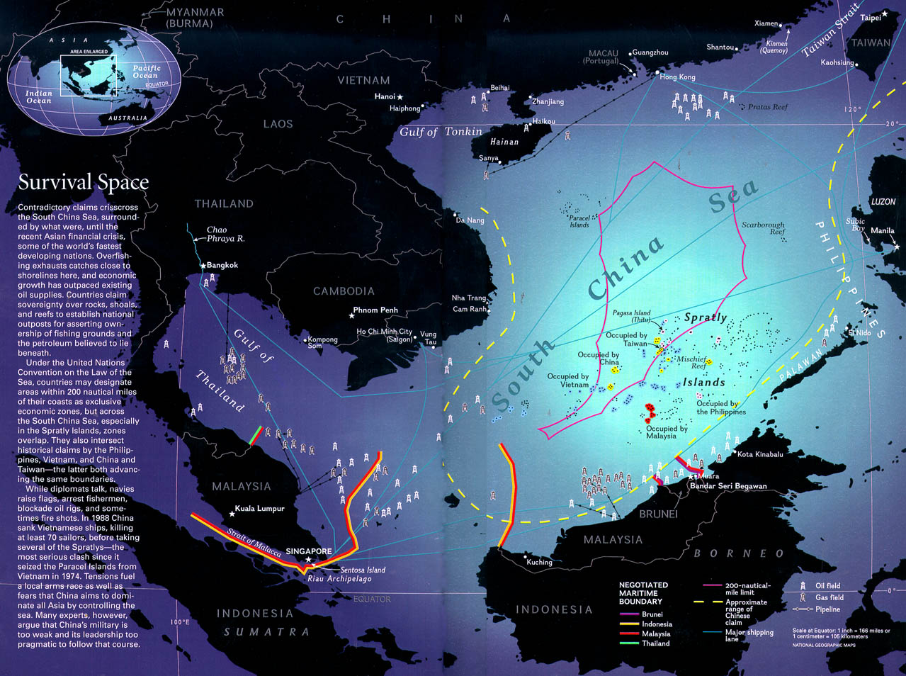
People's Republic of China and the South China Sea History and nowadays status click here to see China claim boundery China's claim is, in part, historical and originates with the Han Dynasty (206 B.C. to 220 A.D.) and the use of the South China Sea by Chinese fishermen since then. The first official claim by China dates from an 1887 treaty with France dividing the Gulf of Tonkin at 108E3'E. China interprets this treaty as extending south beyond the Tonkin Gulf to include all the islands of the South China Sea.3 In 1948, Nationalist China's Ministry of Interior issued a Map of Locations
of South China Sea Islands which depicted China's historical claim as
a broken, U-shaped line that intersects waters off Vietnam, Malaysia,
Brunei, and the Philippines. Both the PRC and Taiwan still cite this U-shaped
claim, although no official declarations defining the nature or extent
of the claim have been made.
In 1958, the PRC issued a "Declaration of Territorial Sea"
that extended China's territorial sea to 12 nautical miles (NM) and claimed
the territory (and corresponding 12 NM territorial seas) of the Spratly
(Nansha) Islands, Taiwan, the Paracels, Macclesfield Bank, and the Pescadores.
In 1992, the PRC's "Law on the Territorial Waters and their Contiguous
Areas" added 24 NM Contiguous Zones, and reiterated the claims of
the 1958 Declaration, and additionally claimed the The first PRC occupation of the Spratlys occurred in 1988 when, after a naval engagement with the Vietnamese, the PRC took possession of several reefs in the Spratlys and established a base at Fiery Cross Reef. Since then, other reefs have also been occupied. Of most recent and greatest immediate contention was the emplacement of markers and the construction of "fisherman's structures" on the Philippine-claimed Mischief Reef in early 1995.
Taiwan: Taipei claims sovereignty over all the islands within the U-shaped line (just as PRC's claim) in the South China Sea, including all the Spratly Islands, and exercises effective control over Itu Aba (Taiping) Island in the Spratly archipelago. Itu Aba has a garrison of marines (approximately 100 troops, down from 500 in the late 1980s), a radar station, a meteorological center, and a power plant. Taiwan is also completing construction on communications facilities on the island and an airstrip is under consideration.
|
|
||||||||||||||
|
|
|||||||||||||||
Choi Xin Zhong,Student of GSAPS, HanYang University |
|||||||||||||||