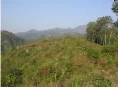
a. Muria Mountain
Mount Muria is an old mountain which places at north part of Java Island and covers three districts in Central Java province: Jepara, Kudus, and Pati. Mount Muria. Mount Muria has two important roles for its district. First, he has role as environmental and ecosystem buffer for lowland area of Jepara, Kudus, and Pati. Jepara, Kudus, and Pati were categorized industrial city because there are many famous and big industries were established. They have high activity, which could have impact for environmental. So, quality of mount Muria ecosystem is important for those three districts.
Second, Mount Muria has role as biodiversity preservation. Forest of mount Muria was the last habitat for rare wildlife in Java, java tiger ( Panthera tigris sondaicus ) and java eagle ( Spizaetus bartelsii ). Unfortunately, deforestation in mount Muria contributes habitat loss for wildlife. It resulted an indication that year 1998 was the last appearance of java tiger at mount Muria .
Based on background above, Relung and UMK ( University of Muria Kudus ) which represent by MRC (Muria research center) has a long-term commitment for conserving Muria Ecosystem. In July 29 - August 15, 2004 Relung and UMK had conducted a program called Multi-aspect Muria Assessment . That Assessment is purposed for getting basic information of Muria from social-economic, policy and biodiversity perspectives.
b.
South Coastal of Java Island
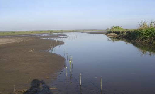
Estuarine ecosystem is
combination of two diffrence ecosystem between river and coastal
(sea) ecosystem. It result unique ecosystem in it and its
uniqueness represent by biodiversity abundace. Many water and land
biota live and contribute to biodiversity abundance in estuarine
ecosystem. In many places estuarine ecosystem takes as human
support life for people who lives around. Unfortunately, nowdays,
condition of estuarine ecosystem is suffering degradation because
of many destructive exploitation activities.
Big potential on estuarine is appearance
of vegetation association called mangrove forest.
It forest type has important
influence to sea ecosystem particularly river estuary. Mangrove
forest has high economic and ecology value. Economically, this
forest type produces many commodities, such as firewood, charcoal,
food resource, cosmetic material, coloring material, skin tannin,
cattle food, fishery, and jelly bee. Beside that, mangrove forest
is suitable habitat for fish and prawn nursery. Ecologically,
forest mangrove has role to keep coast stability by
resisting from abrasion and seawater
intrusion.
South
coastal java particularly where located in Bantul district,
Yogyakarta is coastal area did not cover by mangrove forest. There
are many ecology restriction causing mangrove forest does not
existence in south coastal java. The prime restriction is rough
vulcanic substrat from mount Merapi which carries by the river
flow (Progo and Opak rivers). But based on our riset, estuarine
area in south coastal java is properly fertile for trial riset of
palnting many mangrove species.
River
ecosystem where locates near estuary is also an ecosystem which is
rich of biodiversity and could be used sustainable. Using those
resources need integrated strategy. Based on background above,
Relung has two integrated strategies to manage south coastal java:
-
Action research on estuary management: trial experiment of
mangrove planting, benthos spreading, and keramba making
-
Community empowerment on good governance in sustainable
estuarine ecosystem management.
c.
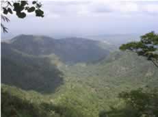
Menoreh Hills
Menoreh hill is situated in Central of Java Island, and cover three districts in the two provinces in the most populated island in the world, Java Island . The three districts are Magelang district, Purworejo district and Kulonprogo district. The magelang and Purworejo is a part of Jawa Tengah ( Central Java ) province, the Kulon Progo district is a part of Daerah Istimewa Yogyakarta province. The Menoreh hill covers about 91,000 hectares in its position 07 0 30' to 07 0 60' S and 110 0 10'to 110 0 25' E. The elevation ranges from 300 to 999 m.
The Menoreh hill is dominated by community forestland. This condition is uncommonly in Indonesian's areas. Most of Indonesian area's, especially in java island, the land is dominated by government land that is managed by PERHUTANI (state company on forestry). The government land only covers several sub districts in the Menoreh hill, Donorejo sub district in Purworejo and Salaman sub district in Magelang. The others twelve sub districts are dominated by community forest land
Community
forest in Menoreh hill has four functions, ecological or
environmentally function, economically function, social function,
and cultural function. These functions are existed in the Menoreh
hills land that is dominated by Community forest. The main RELUNG
program in this region is strengthening farmer ability for
managing their agro-forest. With the support of government
programs farmer in this area has been developing their forest for
since 1970s. But they still have any problem of sustainability
and quality on managing their forest. Some RELUNG activities in
this region are:
-
Establishing information and research centre.
-
Technical Assistance on Agriculture
Technology
-
Post harvesting Management
-
Farmer institution building
-
Small-scale enterprise development.
|